165.125.178.52 - IP Lookup: Free IP Address Lookup, Postal Code Lookup, IP Location Lookup, IP ASN, Public IP
Country:
Region:
City:
Location:
Time Zone:
Postal Code:
IP information under different IP Channel
ip-api
Country
Region
City
ASN
Time Zone
ISP
Blacklist
Proxy
Latitude
Longitude
Postal
Route
Luminati
Country
Region
zh
City
rotterdam
ASN
Time Zone
Europe/Amsterdam
ISP
AS16875
Latitude
Longitude
Postal
IPinfo
Country
Region
City
ASN
Time Zone
ISP
Blacklist
Proxy
Latitude
Longitude
Postal
Route
IP2Location
165.125.178.52Country
Region
utrecht
City
amersfoort
Time Zone
Europe/Amsterdam
ISP
Language
User-Agent
Latitude
Longitude
Postal
db-ip
Country
Region
City
ASN
Time Zone
ISP
Blacklist
Proxy
Latitude
Longitude
Postal
Route
ipdata
Country
Region
City
ASN
Time Zone
ISP
Blacklist
Proxy
Latitude
Longitude
Postal
Route
Popular places and events near this IP address
Amersfoort
City and municipality in Utrecht, Netherlands
Distance: Approx. 635 meters
Latitude and longitude: 52.15,5.38333333
Amersfoort (Dutch pronunciation: [ˈaːmərsfoːrt] ) is a city and municipality in the province of Utrecht, Netherlands. As of 31 January 2023, the municipality had a population of 160,902, making it the second-largest of the province and fifteenth-largest of the country. Amersfoort is also one of the largest Dutch railway junctions with its three stations—Amersfoort Centraal, Schothorst and Vathorst—due to its location on two of the Netherlands' main east to west and north to south railway lines.

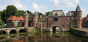
Koppelpoort
Distance: Approx. 448 meters
Latitude and longitude: 52.15888889,5.38527778
The Koppelpoort is a medieval gate in the Dutch city of Amersfoort, province of Utrecht. Completed around 1425, it combines land and water-gates, and is part of the second city wall of Amersfoort, which was constructed between 1380 and 1450.
Mondriaan House
Museum in Amersfoort, the Netherlands
Distance: Approx. 200 meters
Latitude and longitude: 52.15475278,5.39037222
The Mondriaan House (Dutch: Mondriaanhuis, Museum voor Constructieve en Concrete Kunst) is a museum in Amersfoort, the Netherlands, in the house where Piet Mondriaan was born in 1872. The museum lies in the historical centre of Amersfoort. The museum building also includes the structure of the Christian primary school, where Mondrian's father served as the headmaster.

Museum Flehite
Museum in Amersfoort, Netherlands
Distance: Approx. 229 meters
Latitude and longitude: 52.1568,5.3856
Museum Flehite is the historical museum of Amersfoort and Eemland in the Netherlands. The museum was founded in 1880 by the "Oudheidkundige Vereniging Flehite" (Archeological Association Flehite) (1878). In 1890, the museum moved to the first of the current three-part building on the Breestraat (Breestreet).

Amersfoort Centraal railway station
Railway station in Amersfoort, Netherlands
Distance: Approx. 921 meters
Latitude and longitude: 52.15388889,5.37416667
Amersfoort Centraal is the main railway station in Amersfoort in the province of Utrecht, Netherlands. The station was an important link between the western part of the Netherlands and the north and east of the country until December 2012 when the Hanzelijn opened.

Onze Lieve Vrouwetoren
Late gothic church tower in Amersfoort
Distance: Approx. 22 meters
Latitude and longitude: 52.155223,5.387242
The Onze-Lieve-Vrouwetoren (Dutch pronunciation: [ˌɔnzə ˌlivə ˈvrʌu.əˌtoːrə(n)]; "Tower of Our Lady"), nicknamed Lange Jan ("Long John"), is a church tower in Amersfoort. The Late Gothic building is 98.33 metres (322 ft 7 in) tall and reaches high above the inner city. It is one of the most eye-catching monuments in town and the third highest church tower in the Netherlands.
Schothorst
Distance: Approx. 2163 meters
Latitude and longitude: 52.1742,5.3933
Schothorst is the second largest district by population in the Dutch city of Amersfoort. It is located in central Amersfoort, between the districts of Liendert, Landgoed Schothorst (an estate) and De Koppel. The neighbourhood was built in the 1970s and 1980s and today forms a quiet, leafy area of the city.
Mariënhof
Restaurant in Amersfoort, Netherlands
Distance: Approx. 281 meters
Latitude and longitude: 52.15333889,5.39043889
Mariënhof is a defunct restaurant in Amersfoort, in the Netherlands. It was a fine dining restaurant that was awarded one Michelin star in 1996 and retained that rating until 2001. Head chef of Mariënhof was Jon Sistermans.
De Saffraan
Restaurant in Amersfoort, Netherlands
Distance: Approx. 695 meters
Latitude and longitude: 52.16053333,5.3825
De Saffraan is a restaurant located in Amersfoort in the Netherlands. It is a fine dining restaurant that was awarded one Michelin star in the period 2010–2014. GaultMillau awarded the restaurant 15 out of 20 points.
Blok's Restaurant
Restaurant in Amersfoort, Netherlands
Distance: Approx. 174 meters
Latitude and longitude: 52.15660833,5.38818056
Blok's Restaurant was a restaurant located in Amersfoort, Netherlands. It was a fine dining restaurant that was awarded a Michelin star for the period 2013–2019. Blok's was awarded a Bib Gourmand in the period 2007–2012.

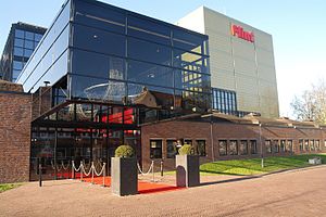
Flint (theatre)
Distance: Approx. 641 meters
Latitude and longitude: 52.15986111,5.39277778
Flint, formerly De Flint, is a theatre in the centre of Amersfoort, Netherlands built in 1977. It was designed by Onno Greiner. The Flint programme includes play, musicals, cabaret and performances for children.
Culture House Eemhuis
Building in Amersfoort
Distance: Approx. 578 meters
Latitude and longitude: 52.159347,5.382637
Culture House Eemhuis is a culture house in Amersfoort, Netherlands was designed by Michiel Riedijk in 2013. The building houses cultural organizations including: a library, institutes of education, a school for arts, and spaces for art exhibition.
Weather in this IP's area
light snow
1 Celsius
1 Celsius
0 Celsius
2 Celsius
1006 hPa
92 %
1006 hPa
1005 hPa
8723 meters
0.89 m/s
3.58 m/s
102 degree
100 %


