Country:
 USA
USARegion:
City:
Latitude and Longitude:
Time Zone:
Postal Code:
IP information under different IP Channel
ip-api
Country
Region
City
ASN
Time Zone
ISP
Blacklist
Proxy
Latitude
Longitude
Postal
Route
IPinfo
Country
Region
City
ASN
Time Zone
ISP
Blacklist
Proxy
Latitude
Longitude
Postal
Route
MaxMind
Country
Region
City
ASN
Time Zone
ISP
Blacklist
Proxy
Latitude
Longitude
Postal
Route
Luminati
Country
USRegion
il
City
chicago
ASN
Time Zone
America/Chicago
ISP
NWU-AS
Latitude
Longitude
Postal
db-ip
Country
Region
City
ASN
Time Zone
ISP
Blacklist
Proxy
Latitude
Longitude
Postal
Route
ipdata
Country
Region
City
ASN
Time Zone
ISP
Blacklist
Proxy
Latitude
Longitude
Postal
Route
Popular places and events near this IP address
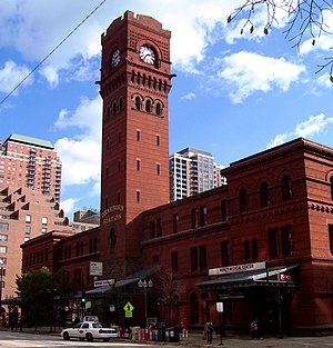
Dearborn Station
Former train station in Chicago, United States
Distance: Approx. 131 meters
Latitude and longitude: 41.87216111,-87.62916667
Dearborn Station (also called, Polk Street Depot) was, beginning in the late 1800s, one of six intercity train stations serving downtown Chicago, Illinois. It remained in operation until May 1, 1971. Built in 1883, it is located at Dearborn and Polk Streets, to the south of the Loop, adjacent to Printers Row.
Jones College Prep High School
School in Chicago, Illinois, United States
Distance: Approx. 310 meters
Latitude and longitude: 41.8737,-87.628
William Jones College Preparatory High School (commonly known as Jones College Prep) is a public 4-year selective-enrollment high school located in the Printer's Row neighborhood in downtown Chicago, Illinois, United States. Jones is operated by the Chicago Public Schools district. Jones was named one of “America’s Best High Schools” for 2010 by Newsweek magazine.

Harrison station (CTA)
Chicago "L" station
Distance: Approx. 358 meters
Latitude and longitude: 41.874039,-87.627479
Harrison is an "L" subway station on the CTA's Red Line in Printer's Row, Chicago in the Loop.
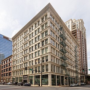
Ludington Building
United States historic place
Distance: Approx. 313 meters
Latitude and longitude: 41.86892778,-87.62634167
The Ludington Building in Chicago, Illinois is a steel-frame building that is the oldest surviving structure of its kind in the city. It is located in the Chicago Loop community area. It was designed by William Le Baron Jenney and was named a Chicago Landmark on June 10, 1996.

Printer's Row, Chicago
Neighborhood in Chicago, Illinois
Distance: Approx. 279 meters
Latitude and longitude: 41.8735,-87.6292
Printers Row, also known as Printing House Row, is a neighborhood located in the south of the Chicago downtown area known as the Loop. The heart of Printers Row is generally defined by Ida B. Wells Drive on the north, Polk Street on the south, Plymouth Court on the east, and the Chicago River on the west. This neighborhood overlaps significantly with the officially designated landmark Printing House Row District to the north of Ida B Wells Drive and the South Loop Printing House District to the south of the Drive.

YMCA Hotel (Chicago, Illinois)
United States historic place
Distance: Approx. 235 meters
Latitude and longitude: 41.87138889,-87.62611111
The YMCA Hotel is a historic former hotel located in the Loop community area of Chicago, Illinois. The hotel, which was designed by Robert C. Berlin and James Gamble Rogers, opened in 1916. Originally marketed by YMCA as a cheap residence for young, single men, the hotel began marketing to a wider clientele when the Great Depression created a demand for inexpensive lodging.

Buddy Guy's Legends
Blues club in Chicago, Illinois, United States
Distance: Approx. 313 meters
Latitude and longitude: 41.872971,-87.626211
Buddy Guy's Legends is a blues club in Chicago, Illinois. It was opened in 1989 by blues musician Buddy Guy who still owns the club and makes regular appearances, performing a month of shows each January. Legends is one of the few blues clubs left in Chicago, a city renowned for its own particular brand of blues.

Lakeside Press Building
United States historic place
Distance: Approx. 173 meters
Latitude and longitude: 41.8725,-87.62833333
The Lakeside Press Building is a historic commercial building located at 731 S. Plymouth Ct. in downtown Chicago, Illinois. The building served as a showroom, office, and printing press for the Lakeside Press.
British International School of Chicago, South Loop
School in Chicago, Illinois, United States
Distance: Approx. 314 meters
Latitude and longitude: 41.87026,-87.63255
The British International School of Chicago, South Loop it is a private international school, located in the South Loop area of Chicago. BISC-SL offers education for ages 3 to 18 (UK Nursery to Year 13/US Pre-K to Grade 12).

Fairbanks, Morse and Company Building
United States historic place
Distance: Approx. 245 meters
Latitude and longitude: 41.87027778,-87.62611111
The Fairbanks, Morse and Company Building is a historic commercial building located at 900 S. Wabash Ave. in the South Loop, Chicago, Illinois. The building served as the national headquarters of Fairbanks, Morse and Company from 1907 to 1937.

Essex on the Park
Apartment building in Chicago
Distance: Approx. 353 meters
Latitude and longitude: 41.8715,-87.6247
Sentral Michigan Avenue or 808 South Michigan (Avenue) is a 479-unit apartment building on South Michigan Avenue in the Loop community area, Chicago, Illinois. It is connected to Le Méridien Essex Chicago at 800 South Michigan Avenue. The development was marketed and opened as Essex on the Park on March 1, 2019, but rebranded as Sentral (stylized as Sen+ral) Michigan Avenue in July 2021.
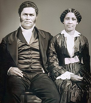
Site of the John and Mary Jones House
Historic landmark in Chicago, Illinois, United States
Distance: Approx. 80 meters
Latitude and longitude: 41.87027778,-87.62888889
The Site of the John and Mary Jones House is a site in Chicago, Illinois, in the United States that was designated as a Chicago Landmark on May 26, 2004.
Weather in this IP's area
broken clouds
9 Celsius
8 Celsius
7 Celsius
11 Celsius
1022 hPa
80 %
1022 hPa
1000 hPa
10000 meters
2.93 m/s
4.26 m/s
292 degree
57 %
06:24:07
19:12:16