164.86.11.82 - IP Lookup: Free IP Address Lookup, Postal Code Lookup, IP Location Lookup, IP ASN, Public IP
Country:
Region:
City:
Location:
Time Zone:
Postal Code:
IP information under different IP Channel
ip-api
Country
Region
City
ASN
Time Zone
ISP
Blacklist
Proxy
Latitude
Longitude
Postal
Route
Luminati
Country
ASN
Time Zone
America/Chicago
ISP
INTELSAT-1
Latitude
Longitude
Postal
IPinfo
Country
Region
City
ASN
Time Zone
ISP
Blacklist
Proxy
Latitude
Longitude
Postal
Route
IP2Location
164.86.11.82Country
Region
virginia
City
mclean
Time Zone
America/New_York
ISP
Language
User-Agent
Latitude
Longitude
Postal
db-ip
Country
Region
City
ASN
Time Zone
ISP
Blacklist
Proxy
Latitude
Longitude
Postal
Route
ipdata
Country
Region
City
ASN
Time Zone
ISP
Blacklist
Proxy
Latitude
Longitude
Postal
Route
Popular places and events near this IP address

Wolf Trap National Park for the Performing Arts
130 acre-park in Virginia (US) maintained by the National Park Service
Distance: Approx. 2918 meters
Latitude and longitude: 38.93694444,-77.26194444
Wolf Trap National Park for the Performing Arts (originally known as the Wolf Trap Farm Park for the Performing Arts and simply known as Wolf Trap) is a performing arts center located on 117 acres (47 ha) of national park land in unincorporated Fairfax County, Virginia, near the town of Vienna. Through a partnership and collaboration of the National Park Service and the non-profit Wolf Trap Foundation for the Performing Arts, the park offers both natural and cultural resources. Its land was donated to the United States government by Catherine Filene Shouse, who sought to preserve her former farm as parkland.

Madeira School
School in McLean, Virginia, United States
Distance: Approx. 1389 meters
Latitude and longitude: 38.96527778,-77.235
The Madeira School (simply referred to as Madeira School or Madeira) is an elite, private, day and boarding college-preparatory school for girls in McLean, Virginia, United States. It was established in 1906 by Lucy Madeira Wing.

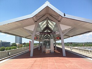
Spring Hill station
Washington Metro station
Distance: Approx. 2697 meters
Latitude and longitude: 38.92916667,-77.24194444
Spring Hill station (preliminary names Tysons West, Tysons–Spring Hill Road) is a Washington Metro station in Fairfax County, Virginia, on the Silver Line. Located in Tysons, it began operation on July 26, 2014. The station is located in the central median of Leesburg Pike (SR 7) just west of Spring Hill Road.
Difficult Run
River in Northern Virginia, United States
Distance: Approx. 2595 meters
Latitude and longitude: 38.97611111,-77.235
Difficult Run is a 15.9-mile-long (25.6 km) tributary stream of the Potomac River in Northern Virginia in the United States. The stream is part of a 57.7-square-mile drainage basin, or watershed, in the north-central portion of Fairfax County, Virginia. Difficult Run flows through Great Falls Park, where it has been characterized as "a miniature Mather Gorge and Great Falls." The stream picks up speed as it runs through a steep gorge with waterfalls, and drains into the Potomac.

Odricks Corner, Virginia
Unincorporated community in Virginia, United States
Distance: Approx. 1612 meters
Latitude and longitude: 38.93861111,-77.23138889
Odricks Corner is an unincorporated community in Fairfax County, Virginia, United States. Odricks Corner lies north of the Dulles Toll Road (State Route 267) at the intersection of Spring Hill and Lewinsville Roads. Odricks Corner takes its name from Alfred Odrick, a former slave and carpenter who in 1872 purchased 30 acres and built a house on the southern side of Lewinsville Road.
National Automobile Dealers Association
American trade organization
Distance: Approx. 3002 meters
Latitude and longitude: 38.925834,-77.234824
The National Automobile Dealers Association (NADA) is an American trade organization representing nearly 16,500 franchised new car and truck dealerships, both domestic and foreign. Established in 1917, the organization is based in Tysons Corner, Virginia. As the automotive retail industry's primary trade association, NADA monitors federal legislation and regulation affecting dealerships and publishes forecasts and reports about industry trends.

Ash Grove (plantation)
Distance: Approx. 2656 meters
Latitude and longitude: 38.9319,-77.2499
Ash Grove is an 18th-century plantation house in Fairfax County, Virginia, United States. In 1790, Bryan Fairfax built Ash Grove on Leesburg Pike, two miles west of present-day Tysons Corner, for his son Thomas Fairfax. Ash Grove is said to have been named for an older Fairfax family house in England.
Towlston Grange
Distance: Approx. 2240 meters
Latitude and longitude: 38.95638889,-77.26055556
Towlston Grange is an 18th-century plantation in Great Falls in Fairfax County, Virginia, United States. The estate served as a residence for several prominent members of the Fairfax family. Towlston Grange is located at 1213 Towlston Road in Great Falls.
International Children's Festival at Wolf Trap
Youth-oriented festival
Distance: Approx. 2918 meters
Latitude and longitude: 38.93698,-77.26197
The International Children's Festival at Wolf Trap was a youth-oriented festival dedicated to the performing, visual, and interactive arts. The festival is held each September at Wolf Trap National Park for the Performing Arts in Fairfax County, Virginia, which is the United States' only national park devoted solely to the performing arts. First conceived in 1971 as "International Children's Day", the festival provides opportunities for children to share aspects of their culture through the arts.
Spring Hill Farm (McLean, Virginia)
Historic house in Virginia, United States
Distance: Approx. 990 meters
Latitude and longitude: 38.94795667,-77.22550278
Spring Hill Farm is a historic home located at Great Falls, Fairfax County, Virginia. It was built about 1822, and is a 2+1⁄2-story, frame farmhouse dwelling in the Federal style. A two-story rear wing was added in 1850.
IQ Business Group
Distance: Approx. 2260 meters
Latitude and longitude: 38.9325,-77.23555556
The iQ Business Group, Inc. (IQBG) is an American multinational corporation headquartered in McLean, Virginia.
Bois Doré (McLean, Virginia)
Historic house in McLean, Virginia, US
Distance: Approx. 1463 meters
Latitude and longitude: 38.9612,-77.2221
Bois Doré is a historic house located in McLean, Virginia, United States along Virginia State Route 193 (Georgetown Pike). It was built in 1951 and was added to the Virginia Landmarks Register and the National Register of Historic Places in 2020.
Weather in this IP's area
overcast clouds
1 Celsius
1 Celsius
-0 Celsius
2 Celsius
1031 hPa
80 %
1031 hPa
1020 hPa
10000 meters
100 %

