Country:
Region:
City:
Latitude and Longitude:
Time Zone:
Postal Code:
IP information under different IP Channel
ip-api
Country
Region
City
ASN
Time Zone
ISP
Blacklist
Proxy
Latitude
Longitude
Postal
Route
Luminati
Country
Region
14
City
oulu
ASN
Time Zone
Europe/Helsinki
ISP
Cinia Oy
Latitude
Longitude
Postal
IPinfo
Country
Region
City
ASN
Time Zone
ISP
Blacklist
Proxy
Latitude
Longitude
Postal
Route
db-ip
Country
Region
City
ASN
Time Zone
ISP
Blacklist
Proxy
Latitude
Longitude
Postal
Route
ipdata
Country
Region
City
ASN
Time Zone
ISP
Blacklist
Proxy
Latitude
Longitude
Postal
Route
Popular places and events near this IP address
Oulu International School
School in Oulu, Finland
Distance: Approx. 669 meters
Latitude and longitude: 65.01666667,25.48055556
Oulu International School (OIS) is a public, not-for-profit, co-educational international school in the Myllytulli district in Oulu, Finland. The school was founded in 2001. It is one of nine English-speaking schools in Finland that offer basic education.

Raatti Stadium
Stadium in Oulu, Finland
Distance: Approx. 668 meters
Latitude and longitude: 65.01972222,25.46583333
Raatti Stadium (Finnish: Raatin stadion) is a multi-purpose stadium in the Koskikeskus neighbourhood of Oulu, Finland. It is the home stadium of AC Oulu, competing in Finnish top-tier Veikkausliiga, and it is currently used mostly for football matches. The stadium holds 4,392 people.

Northern Ostrobothnia Museum
Provincial museum in Oulu, Finland
Distance: Approx. 555 meters
Latitude and longitude: 65.01777778,25.47527778
The Northern Ostrobothnia Museum (Finnish: Pohjois-Pohjanmaan museo) is a museum of cultural history. This provincial museum focuses on the city of Oulu and its surrounding Northern Ostrobothnia region. The museum is situated in the Hupisaaret Islands park in the Myllytulli neighbourhood in Oulu, Finland.
Tuira Church
Church in Oulu, Finland
Distance: Approx. 211 meters
Latitude and longitude: 65.02444444,25.47722222
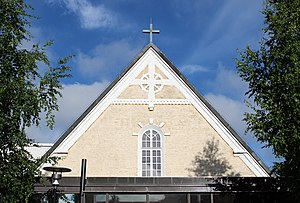
The Tuira Church (Finnish: Tuiran kirkko) is an evangelical Lutheran church in Tuira, Oulu. The church building has been designed by architect Harald Andersin and it was inaugurated as a chapel of Oulu parish in 1916. The parish of Oulu was divided into smaller parishes in 1966 and the chapel in Tuira was inaugurated as a church.

Tuira, Oulu
District of Oulu in Finland
Distance: Approx. 511 meters
Latitude and longitude: 65.026,25.471
Tuira is a district of the city of Oulu, Finland. It is located north of city centre across the Oulujoki River. After the first bridges over Oulujoki connecting Tuira with Oulu were built in 1869, population growth of Tuira accelerated and Tuira was annexed by city of Oulu from the neighbouring rural municipality in 1886.

Myllytulli
District of Oulu in Finland
Distance: Approx. 673 meters
Latitude and longitude: 65.017,25.4837
Myllytulli is a district of the city centre area of Oulu, Finland. Myllytulli was mostly industrial area, which was rezoned mostly for residential use in 1984. Some of the old industrial buildings were preserved and renovated as museums such as Oulu Museum of Art, Tietomaa science centre, fire damaged Myllytulli power plant is being renovated as an art gallery.

Tietomaa
Science Center in Myllytulli, Oulu
Distance: Approx. 576 meters
Latitude and longitude: 65.01805556,25.48416667
Tietomaa is a science centre in Oulu, Finland. It is located in Myllytulli district near the city centre. It is the first science centre in Finland and it was opened to the public on 29 June 1988.

Oulu Museum of Art
Art museum in Myllytulli, Oulu
Distance: Approx. 505 meters
Latitude and longitude: 65.01833333,25.48194444
The Oulu Museum of Art (OMA) is an art museum in the Myllytulli neighbourhood in Oulu. It is located on the edge of the Hupisaaret Islands park. The museum was opened to the public on October 12, 1963.

Koskikeskus
District of Oulu in Finland
Distance: Approx. 592 meters
Latitude and longitude: 65.02055556,25.46666667
Koskikeskus (literally Rapids Center in Finnish) is a neighbourhood in the Tuira area in the city of Oulu, Finland. The neighbourhood is located in the estuary of the river Oulujoki. The Tuira Bridges in Koskikeskus connect the city centre and Tuira neighbourhoods.
Merikoski Power Plant
Dam in Oulu
Distance: Approx. 234 meters
Latitude and longitude: 65.02277778,25.47333333
Merikoski Power Plant is a hydroelectric power station and a dam in the Koskikeskus district in Oulu, Finland. The plant is owned by the Oulun Energia municipal enterprise of the city of Oulu. Construction of the power plant was started in 1940, but electricity generation for national grid was not started until 1948.
Oulu Prison
Prison in Oulu, Finland
Distance: Approx. 728 meters
Latitude and longitude: 65.01805556,25.48944444
The Oulu Prison (earlier known as Oulu Provincial Prison) is a prison located in the Myllytulli neighbourhood in Oulu, Finland. There are 80 prison places, of which ten are reserved for female prisoners. The mean prison population in 2012 was 87.
Hupisaaret Islands
Public urban park in Oulu, Finland
Distance: Approx. 476 meters
Latitude and longitude: 65.01833333,25.4775
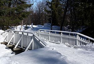
The Hupisaaret Islands City Park is a public urban park in the Myllytulli district in central Oulu, Finland. The park is located in the delta of the River Oulu. The area was built as a public park in the 1860s, the first white wooden bridges that characterize the park were also built at the time.
Weather in this IP's area
clear sky
-3 Celsius
-3 Celsius
-3 Celsius
-3 Celsius
1030 hPa
100 %
1030 hPa
1030 hPa
10000 meters
1.03 m/s
08:38:21
15:25:49


