164.163.12.55 - IP Lookup: Free IP Address Lookup, Postal Code Lookup, IP Location Lookup, IP ASN, Public IP
Country:
Region:
City:
Location:
Time Zone:
Postal Code:
IP information under different IP Channel
ip-api
Country
Region
City
ASN
Time Zone
ISP
Blacklist
Proxy
Latitude
Longitude
Postal
Route
Luminati
Country
Region
pe
City
paulista
ASN
Time Zone
America/Recife
ISP
DTEL TELECOM
Latitude
Longitude
Postal
IPinfo
Country
Region
City
ASN
Time Zone
ISP
Blacklist
Proxy
Latitude
Longitude
Postal
Route
IP2Location
164.163.12.55Country
Region
pernambuco
City
recife
Time Zone
America/Recife
ISP
Language
User-Agent
Latitude
Longitude
Postal
db-ip
Country
Region
City
ASN
Time Zone
ISP
Blacklist
Proxy
Latitude
Longitude
Postal
Route
ipdata
Country
Region
City
ASN
Time Zone
ISP
Blacklist
Proxy
Latitude
Longitude
Postal
Route
Popular places and events near this IP address

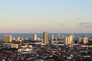
Boa Viagem, Recife
Neighborhood in Pernambuco, Northeast, Brazil
Distance: Approx. 56 meters
Latitude and longitude: -8.05389,-34.8808
Boa Viagem is a neighborhood in Recife, Pernambuco in the wealthy southern zone of the municipality. The neighborhood has one of the most visited beaches in Northeastern Brazil, Boa Viagem beach. The neighborhood has a population as of 2010 of 122,922 inhabitants, and an area of 753 hectares (2.91 sq mi).

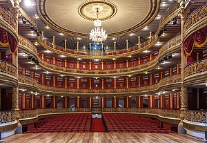
Santa Isabel Theater
Theater in Recife, Brazil
Distance: Approx. 831 meters
Latitude and longitude: -8.06070556,-34.87843889
Santa Isabel Theater (Teatro de Santa Isabel in Portuguese) is located in the Brazilian city of Recife, capital of Pernambuco state. It was inaugurated on 18 May 1850, and seats 850 in the audience. It was named in honor of Princess Isabel of Braganza.

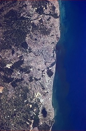
Greater Recife
Metro Area in Northeast, Brazil
Distance: Approx. 52 meters
Latitude and longitude: -8.053889,-34.880833
Recife Metropolitan Area, officially the Metropolitan Region of Recife (Portuguese: Região Metropolitana do Recife (RMR), or Grande Recife), is a major metropolitan area in Northeast Brazil with a population of 3,7 million as of 2022, centered on the state capital of Recife, Pernambuco. In 2017, it was ranked as the 8th largest metropolitan region nationally. The Brazilian Institute of Geography and Statistics (IBGE) defines the region as a "metropolis" in its Area of Influence surveys, in terms of economic and social importance.
Catholic University of Pernambuco
Distance: Approx. 727 meters
Latitude and longitude: -8.0549,-34.8878
The Catholic University of Pernambuco (Portuguese: Universidade Católica de Pernambuco, Unicap) in Recife, Pernambuco, Brazil, is a Catholic University, private and non-profit, run by the Society of Jesus. It is considered one of the best universities in Brazil, and the best private one in the north and northeast of Brazil.

Cemitério dos Ingleses, Recife
Protestant cemetery in Brazil
Distance: Approx. 911 meters
Latitude and longitude: -8.04722222,-34.87638889
The Cemitério dos Ingleses is a cemetery in Recife, the capital of Pernambuco in Brazil. It was built in 1814, and at the time was named British Cemetery.

Legislative Assembly of Pernambuco
Distance: Approx. 534 meters
Latitude and longitude: -8.05833333,-34.87972222
The Legislative Assembly of Pernambuco (Portuguese: Assembleia Legislativa de Pernambuco, Alepe) is the unicameral legislature of the state of Pernambuco, Brazil. It has 49 state deputies elected by proportional representation. The most recent election was in 2018, with the Brazilian Socialist Party leading the coalition government.

Monument Tortura Nunca Mais
Monument in Padre Henrique plaza in Recife, Pernambuco, Brazil
Distance: Approx. 492 meters
Latitude and longitude: -8.05645,-34.87773
The Monument Tortura Nunca Mais is a monument located in Padre Henrique plaza in Recife, Pernambuco, Brazil. It was conceived by the architect Demétrio Albuquerque. It was the first monument built in honor of the dead and disappeared during the military dictatorship.

Santo Amaro, Recife
Place in Northeast, Brazil
Distance: Approx. 893 meters
Latitude and longitude: -8.046227,-34.8786306
Santo Amaro is a neighborhood of Recife in the state of Pernambuco in Brazil, was founded in 1681 and incorporated in 1814. In 1814, the Cemitério dos Ingleses was built in the neighborhood, the first of the city, on a land donated by the Provincial Government to the English Consul in March 1869.

Limoeiro Bridge
Bridge in Recife, Pernambuco, Brazil
Distance: Approx. 971 meters
Latitude and longitude: -8.0506,-34.8731
Ponte do Limoeiro (Limoeiro Bridge) is a bridge in the city of Recife, Pernambuco, Brazil. It connects Avenida Norte Miguel de Alencar to the Apolo pier, in the Recife neighborhood. Dating back to 1881, it was built from iron for the passage of trains destined for the city of Limoeiro.
TV Jornal
Television station in Recife, Pernambuco
Distance: Approx. 331 meters
Latitude and longitude: -8.05297222,-34.87841667
TV Jornal (channel 2) is a television station licensed to Recife, capital of the state of Pernambuco, Brazil and is affiliated with SBT. It is part of the Sistema Jornal do Commercio de Comunicação, a subsidiary of the JCPM Group, owned by businessman João Carlos Paes Mendonça. Founded on June 18, 1960, it is the oldest TV station still in operation in the Northeast Region of Brazil.
TV Universitária (Recife)
Television station in Pernambuco, Brazil
Distance: Approx. 854 meters
Latitude and longitude: -8.04941667,-34.87494444
TV Universitária is a Brazilian television station based in Recife, capital of the state of Pernambuco. It operates on channel 11 (UHF digital 40) and is affiliated to TV Brasil. It belongs to the University Radio and TV Center of the Federal University of Pernambuco, which also includes radio stations Paulo Freire and Universitária FM. It was opened in 1968, being the first educational TV station created in the country.

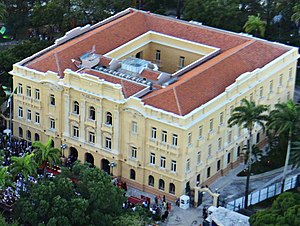
Campo das Princesas Palace
Administrative headquarters of Pernambuco's executive branch
Distance: Approx. 807 meters
Latitude and longitude: -8.06,-34.8775
The Campo das Princesas Palace is the administrative headquarters of Pernambuco's executive branch, located in Recife, Brazil. Designed in 1786 by Governor José César Meneses, it was built in 1841 by engineer Morais Âncora, at the behest of Governor Francisco do Rego Barros, where the Royal Treasury used to be. It is located in the neighborhood of Santo Antônio (Antônio Vaz Island), in Praça da República, next to the Santa Isabel Theater and the Palace of Justice.
Weather in this IP's area
scattered clouds
30 Celsius
34 Celsius
30 Celsius
30 Celsius
1011 hPa
66 %
1011 hPa
1010 hPa
10000 meters
6.17 m/s
120 degree
40 %