Country:
Region:
City:
Latitude and Longitude:
Time Zone:
Postal Code:
IP information under different IP Channel
ip-api
Country
Region
City
ASN
Time Zone
ISP
Blacklist
Proxy
Latitude
Longitude
Postal
Route
Luminati
Country
ASN
Time Zone
Europe/Madrid
ISP
Cyberneticos Hosting SL
Latitude
Longitude
Postal
IPinfo
Country
Region
City
ASN
Time Zone
ISP
Blacklist
Proxy
Latitude
Longitude
Postal
Route
db-ip
Country
Region
City
ASN
Time Zone
ISP
Blacklist
Proxy
Latitude
Longitude
Postal
Route
ipdata
Country
Region
City
ASN
Time Zone
ISP
Blacklist
Proxy
Latitude
Longitude
Postal
Route
Popular places and events near this IP address

Battle of Guadalete
8th-century battle between the Visigothic Kingdom and the Umayyad Caliphate
Distance: Approx. 1980 meters
Latitude and longitude: 36.6,-6.2167
The Battle of Guadalete was the first major battle of the Muslim conquest of the Iberian Peninsula, fought in 711 at an unidentified location in what is now southern Spain between the Visigoths under their king, Roderic, and the invading forces of the Umayyad Caliphate, composed mainly of Berbers and some Arabs under the commander Tariq ibn Ziyad. The battle was significant as the culmination of a series of Berber attacks and the beginning of al-Andalus. Roderic was killed in the battle, along with many members of the Visigothic nobility, opening the way for the capture of the Visigothic capital of Toledo.

El Puerto de Santa María
Municipality in Andalusia, Spain
Distance: Approx. 3218 meters
Latitude and longitude: 36.60146944,-6.23814722
El Puerto de Santa María (Spanish pronunciation: [el ˈpweɾto ðe ˈsanta maˈɾi.a], lit. "the Port of Saint Mary"), locally known as El Puerto and historically in English as Port Saint Mary, is a municipality of Spain located on the banks of the Guadalete River in the province of Cádiz, Andalusia. As of 2016, the city has a population of c.
Plaza de toros de El Puerto
Distance: Approx. 3131 meters
Latitude and longitude: 36.59694444,-6.23277778
The Real Plaza de Toros de El Puerto de Santa María is a bullring in El Puerto de Santa María, Spain. Dating from the 19th century, it has an eclectic architectural style and was completed in 1880. It is the work of Manuel Portillo de Avila y Herrera.
Sherry Golf Jerez
Golf course in Andalusia, Spain
Distance: Approx. 6722 meters
Latitude and longitude: 36.65954419,-6.154876
Sherry Golf Jerez is a golf course located in Jerez de la Frontera in Andalusia, Spain.
Castle of San Marcos (El Puerto de Santa María)
Historic site in Cádiz, Spain
Distance: Approx. 2800 meters
Latitude and longitude: 36.5964,-6.22664167
Castle of San Marcos (also Castillo de Alfonso X El Sabio) is a medieval castle located in El Puerto de Santa María, Cádiz, Spain. The castle was erected as a fortified church by King Alfonso X of Castile. It was built on the site of a mosque of which the wall of the qibla survives.

Monasterio de la Victoria, Province of Cadiz
Historic site in Cádiz, Spain
Distance: Approx. 1482 meters
Latitude and longitude: 36.60566111,-6.21746667
Monasterio de la Victoria is a former monastery located in El Puerto de Santa María, province of Cádiz, southern Spain. It was built in the 16th century by Dukes of Medinaceli. The buildings housed a prison between 1886 and 1981.
Priory Church, El Puerto de Santa María
Historic site in Cádiz, Spain
Distance: Approx. 2657 meters
Latitude and longitude: 36.59982222,-6.22887778
The Priory Church (Spanish: Iglesia Mayor Prioral) is a minor basilica church in El Puerto de Santa María, province of Cádiz, Spain. It is documented from 1486 when the building was under construction. It was damaged by an earthquake in the 17th century and was partly rebuilt in the Baroque style.

Museo Arqueológico Municipal de El Puerto de Santa María
Local museum in El Puerto de Santa María, Spain
Distance: Approx. 2693 meters
Latitude and longitude: 36.599125,-6.22860278
The Museo Arqueológico Municipal de El Puerto de Santa María is a museum located in El Puerto de Santa María, in the province of Cádiz, southern Spain. It was founded in 1980. It contains paintings and sculptures of Francisco Lameyer, Eulogio Varela Sartorio, Enrique Ochoa, Fernando Jesús, Juan Lara, Manolo Prieto, and some works of Rafael Alberti.

San Pedro (river)
Distance: Approx. 7589 meters
Latitude and longitude: 36.54784444,-6.20916389
San Pedro is a small stream in the province of Cádiz, Spain, close to Guadalete river. It runs for 25 km into the Bay of Cádiz. It flows by Bahía de Cádiz Natural Park.

House of Vizarrón
House in El Puerto de Santa María, Spain
Distance: Approx. 2944 meters
Latitude and longitude: 36.594917,-6.226906
The House of Vizarrón (Spanish: La Casa Vizarrón o de las Cadenas) is a house located in El Puerto de Santa María, Spain. It was declared Bien de Interés Cultural in 2006.

Castle of Doña Blanca
Historic site in Puerto de Santa María, Spain
Distance: Approx. 4268 meters
Latitude and longitude: 36.627857,-6.161585
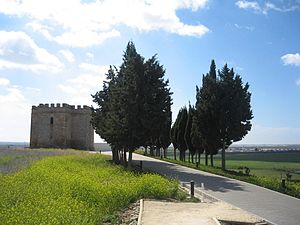
The Castle of Doña Blanca (Spanish: Castillo de Doña Blanca) is a castle located in Puerto de Santa María, Spain. It was declared Bien de Interés Cultural in 1993.
Museo Fundación Rafael Alberti
Biographical museum in El Puerto de Santa María, Spain
Distance: Approx. 2741 meters
Latitude and longitude: 36.5982,-6.2282
The Museo Fundación Rafael Alberti is a museum in El Puerto de Santa María, Spain. It explores the life of the writer and poet Rafael Alberti.
Weather in this IP's area
clear sky
16 Celsius
16 Celsius
15 Celsius
18 Celsius
1014 hPa
93 %
1014 hPa
1013 hPa
10000 meters
3.09 m/s
100 degree
08:03:01
18:16:11


