Country:
 Switzerland
Region:
City:
Latitude and Longitude:
Time Zone:
Postal Code:
IP information under different IP Channel
ip-api
Country
Region
City
ASN
Time Zone
ISP
Blacklist
Proxy
Latitude
Longitude
Postal
Route
IPinfo
Country
Region
City
ASN
Time Zone
ISP
Blacklist
Proxy
Latitude
Longitude
Postal
Route
MaxMind
Country
Region
City
ASN
Time Zone
ISP
Blacklist
Proxy
Latitude
Longitude
Postal
Route
Luminati
Country
CHASN
Time Zone
Europe/Zurich
ISP
Bluewin
Latitude
Longitude
Postal
db-ip
Country
Region
City
ASN
Time Zone
ISP
Blacklist
Proxy
Latitude
Longitude
Postal
Route
ipdata
Country
Region
City
ASN
Time Zone
ISP
Blacklist
Proxy
Latitude
Longitude
Postal
Route
Popular places and events near this IP address

Haus Konstruktiv
Distance: Approx. 412 meters
Latitude and longitude: 47.3725,8.5323
Haus Konstruktiv (English: Foundation for Constructive and Concrete Art), or Museum Haus Konstruktiv, is an arts foundation founded by private individuals in 1986 in Zürich, Switzerland. From 1987 to spring 2001, it was located at Seefeldstrasse 317 in the outer Seefeld area of Zurich and was known as the "House for Constructive and Concrete Art". The new premises are close to the centre of Zurich at Selnaustrasse 25, in a former power station building.

Langstrasse
Quarter of the city of Zurich, Switzerland
Distance: Approx. 212 meters
Latitude and longitude: 47.37626944,8.52667222
Langstrasse (lit. 'long street') is a street and quarter in district 4 in Zürich. Langstrasse begins near the district courts and extends north-northeast to the train tracks of Zürich Hauptbahnhof. The following short segment of Langstrasse leads towards Limmatplatz in district 5.

Battle of St. Jakob an der Sihl
1443 battle of the Old Zürich War
Distance: Approx. 256 meters
Latitude and longitude: 47.37361111,8.53083333
The Battle of St. Jakob an der Sihl was a battle of the Old Zürich War that occurred on July 22, 1443, resulting in a defeat for Zürich. The battle took place outside the gates of Zürich, beyond the Sihl (today's Aussersihl district).
Ristorante Cooperativo
Distance: Approx. 94 meters
Latitude and longitude: 47.3737,8.5281
The Ristorante Cooperativo, colloquially known as Coopi, is a restaurant in Zürich, Switzerland, known for its association with 20th-century left-wing political figures as well as the anti-fascist, trade union and Italian immigrant movements in Switzerland. The restaurant's roots are in the Società Cooperativa Italiana Zurigo, founded by Italian immigrants in 1905 for "furthering Socialist cooperation". Apart from a library, the society also founded the Ristorante Cooperativo to allow immigrants to eat at affordable prices, and continues to operate it today.
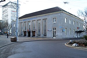
Zürich Wiedikon railway station
Urban railway station in western Zürich, Switzerland
Distance: Approx. 466 meters
Latitude and longitude: 47.3715,8.52338889
Zürich Wiedikon railway station (German: Bahnhof Zürich Wiedikon) is a railway station on the Zürich S-Bahn system in Wiedikon in the western part of the Swiss city of Zürich. It is the only railway station in Switzerland where the ticket office building is located on a bridge above the tracks – in German, this is known as Reiterbahnhof. The station is served by S-Bahn trains on the Lake Zürich left bank line approaching the city from the south and south-east directions.

Aussersihl
District in Zürich, Switzerland
Distance: Approx. 77 meters
Latitude and longitude: 47.375,8.527
Aussersihl is a district in the Swiss city of Zürich. Known officially as District number 4, the district is known as colloquially Chreis Cheib, cheib being the Zürich German word for an animal cadaver. It earned the name as the area historically contained pits for the deposition of dead animals.
Helvetiaplatz (Zürich)
Distance: Approx. 191 meters
Latitude and longitude: 47.37613,8.52691
The Helvetiaplatz in Zürich is located in the District 4 (ger.: Kreis 4) at the corner Langstrasse and Stauffacherstrasse. The first project of pastor Ernst Sieber's Sozialwerke Pfarrer Sieber for homeless people started at Helvetiaplatz in winter 1963; the foundation is still based in Zürich-Aussersihl. The place is well known because of the demonstrations on 1 May and against the World Economic Forum.

Stauffacher
Distance: Approx. 159 meters
Latitude and longitude: 47.3735,8.5292
Stauffacher is a tram junction (lines 2, 3, 8, 9, 14) in Aussersihl, Zurich, next to the St. Jakob church, situated along the Badenerstrasse between the Bäcker and the Stauffacher streets. The tram stop was named after the street, which had been named for Werner Stauffacher in 1893.

Werd (Zürich)
Place in Zürich, Switzerland
Distance: Approx. 366 meters
Latitude and longitude: 47.371225,8.52814722
Werd is a quarter in district 4, Aussersihl in Zürich, Switzerland. The three quarters of district 4, Aussersihl are Werd, Langstrasse and Hard. Werd is the southernmost quarter of district 4 and it borders with the Langstrasse, Quarter of district 4 to the north; the City Quarter of district 1, Altstadt to the east; the Sihlfeld Quarter of district 3, Wiedikon to the west, and the Enge Quarter of district 2, West side of the Lake to the south.
Gefängnis Zürich
Distance: Approx. 91 meters
Latitude and longitude: 47.374732,8.526542
The Gefängnis Zürich (Zürich Prison) is a prison in the city of Zürich, Switzerland, located at the Rotwandstrasse.
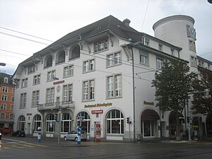
Volkshaus
Distance: Approx. 123 meters
Latitude and longitude: 47.37555556,8.52722222
The Volkshaus is a 1,200-seat concert hall located in Zürich, Switzerland. The building construction began in June 1909 and publicly opened the following year.

Zürich Selnau railway station
Underground railway station in the centre of the Swiss city of Zürich
Distance: Approx. 376 meters
Latitude and longitude: 47.3729,8.5321
Zürich Selnau (German: Zürich Selnau or Bahnhof Selnau) is an underground railway station on the Zürich S-Bahn system in Selnau in the centre of the Swiss city of Zürich. The station is on a section of tunnel under the River Sihl, common to the Uetliberg line and the Sihltal line. Only S-Bahn services call at Selnau station, which are operated by the Sihltal Zürich Uetliberg Bahn (SZU).
Weather in this IP's area
overcast clouds
14 Celsius
14 Celsius
13 Celsius
15 Celsius
1012 hPa
96 %
1012 hPa
964 hPa
6000 meters
3.09 m/s
250 degree
100 %
07:48:51
18:32:46