Country:
 India
IndiaRegion:
City:
Latitude and Longitude:
Time Zone:
Postal Code:
IP information under different IP Channel
ip-api
Country
Region
City
ASN
Time Zone
ISP
Blacklist
Proxy
Latitude
Longitude
Postal
Route
IPinfo
Country
Region
City
ASN
Time Zone
ISP
Blacklist
Proxy
Latitude
Longitude
Postal
Route
MaxMind
Country
Region
City
ASN
Time Zone
ISP
Blacklist
Proxy
Latitude
Longitude
Postal
Route
Luminati
Country
INASN
Time Zone
Asia/Kolkata
ISP
National Informatics Centre
Latitude
Longitude
Postal
db-ip
Country
Region
City
ASN
Time Zone
ISP
Blacklist
Proxy
Latitude
Longitude
Postal
Route
ipdata
Country
Region
City
ASN
Time Zone
ISP
Blacklist
Proxy
Latitude
Longitude
Postal
Route
Popular places and events near this IP address

Vikarabad
Town in Telangana, India
Distance: Approx. 1761 meters
Latitude and longitude: 17.33,77.9
Vikarabad is a town and mandal in Vikarabad district of the Indian state of Telangana. It is located in Vikarabad mandal of Vikarabad revenue division.

Parkwood School International
International boarding school in Hyderabad, Telangana, India
Distance: Approx. 9632 meters
Latitude and longitude: 17.28023611,77.97962778
Parkwood School International (PSI) was a co-educational residential school, about 65 km away from Hyderabad, Telangana, India. Parkwood provided education for children from grade 3 to 12. The school once offered CBSE, University of Cambridge IGCSE and A-Levels.
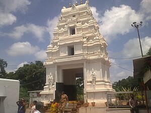
Ananthagiri Temple
Hindu temple in Telangana, India
Distance: Approx. 6295 meters
Latitude and longitude: 17.3099,77.8628
Sri Anantha Padmanabha Swamy or Ananthagiri Temple is a Hindu temple located in Ananthagiri, Vikarabad district in Telangana, India. It is temple of Lord Vishnu. The temple is about 75 km from Gachibowli, Hyderabad.

Vikarabad Assembly constituency
Constituency of the Telangana legislative assembly in India
Distance: Approx. 1426 meters
Latitude and longitude: 17.34,77.9
Vikarabad Assembly constituency is constituency of the Telangana Legislative Assembly, in India. It is one of 04 constituencies in the Vikarabad District. It is part of the Chevella Lok Sabha constituency.
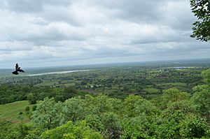
Ananthagiri Hills, Vikarabad district
Hills in Telangana, India
Distance: Approx. 6158 meters
Latitude and longitude: 17.312,77.863
Ananthagiri Hills is located in Vikarabad district, Telangana, India. The water flows from these hills to Osman Sagar, also known as Gandipet lake, and Himayathsagar. It is one of the dense forests in Telangana.

Vikarabad Junction railway station
Railway station in India
Distance: Approx. 1761 meters
Latitude and longitude: 17.33,77.9
Vikarabad railway station is an Indian Railways station in the town of Vikarabad in Telangana. It is located on the Vikarabad–Parli section of Secunderabad railway division in South Central Railway zone.
Weather in this IP's area
broken clouds
24 Celsius
25 Celsius
24 Celsius
24 Celsius
1012 hPa
82 %
1012 hPa
942 hPa
10000 meters
3.05 m/s
4.91 m/s
102 degree
57 %
06:12:17
17:53:58