Country:
 India
IndiaRegion:
City:
Latitude and Longitude:
Time Zone:
Postal Code:
IP information under different IP Channel
ip-api
Country
Region
City
ASN
Time Zone
ISP
Blacklist
Proxy
Latitude
Longitude
Postal
Route
IPinfo
Country
Region
City
ASN
Time Zone
ISP
Blacklist
Proxy
Latitude
Longitude
Postal
Route
MaxMind
Country
Region
City
ASN
Time Zone
ISP
Blacklist
Proxy
Latitude
Longitude
Postal
Route
Luminati
Country
INASN
Time Zone
Asia/Kolkata
ISP
National Informatics Centre
Latitude
Longitude
Postal
db-ip
Country
Region
City
ASN
Time Zone
ISP
Blacklist
Proxy
Latitude
Longitude
Postal
Route
ipdata
Country
Region
City
ASN
Time Zone
ISP
Blacklist
Proxy
Latitude
Longitude
Postal
Route
Popular places and events near this IP address

Manipur
State in northeastern India
Distance: Approx. 106 meters
Latitude and longitude: 24.81,93.94
Manipur (, US also ; Meitei: Kangleipak) is a state in northeast India, with the city of Imphal as its capital. It is bounded by the Indian states of Nagaland to the north, Mizoram to the south and Assam to the west. It also borders two regions of Myanmar, Sagaing Region to the east and Chin State to the south.
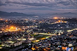
Imphal
Capital city of the Indian state Manipur
Distance: Approx. 328 meters
Latitude and longitude: 24.8074,93.9384
Imphal (Meitei: [im.pʰal]; English: UK: , US: ) is the capital city of the Indian state of Manipur. It is the third largest city in northeast India after Guwahati and Agartala. The metropolitan centre of the city contains the ruins of Kangla Palace (officially known as Kangla Fort), the royal seat of the former Kingdom of Manipur, surrounded by a moat.

Kangla fort
Fortified Palace in Manipur, India
Distance: Approx. 275 meters
Latitude and longitude: 24.808,93.94
The Kangla with diacritic Kanglā, officially known as the Kangla Fort, is an old fortified palace at Imphal, in the Manipur state of India. It was formerly situated on both sides (western and eastern) of the bank of the Imphal River, now remaining only on the western side in ruined conditions. Kangla means "the prominent part of the dry land" in old Meetei.
Raj Bhavan, Imphal
Building
Distance: Approx. 816 meters
Latitude and longitude: 24.803253,93.936769
Raj Bhavan (translation: Government House) is the official residence of the governor of Manipur. The present structure was completed in 1898 after the old thatched roofed structure was destroyed in the Anglo-Manipuri War of 1891. It is located in the capital city of Imphal, Manipur and the area of the campus is 16 acres (65,000 m2).
Manipur Public Service Commission
State government agency
Distance: Approx. 1027 meters
Latitude and longitude: 24.817938,93.944698
The Manipur Public Service Commission (MPSC) is a constitutional body of the state of Manipur, India, responsible for the recruitment of candidates for various state government jobs through competitive examinations. It also gives concurrence on the recommendation of Departmental Promotion Committee for appointment to various posts. The Commission also gives concurrence on the framing/ amendment of Recruitment Rules.
Johnstone Higher Secondary School, Imphal
Government school in Imphal, Manipur, India
Distance: Approx. 489 meters
Latitude and longitude: 24.806,93.938
Johnstone Higher Secondary School is a premier higher secondary school in Manipur located at the heart of Imphal city in Bir Tikendrajit Road. The school is an institution recognised by Council of Higher Secondary Education, Manipur.

Ima Market
Place in Manipur, India
Distance: Approx. 478 meters
Latitude and longitude: 24.808,93.935
The Ima Market (Meitei: Ima Keithel; literally, Mothers' Market), also known as the Nupi Keithel (English: Women's Market) or the Khwairamband Keithel (English: Khwairamband Market), is a women-only market in the middle of Imphal in the Indian state of Manipur. It is the only market in the world run entirely by women. Inside the market, male shopkeepers and vendors are not allowed to sell anything.

Manipur State Museum
Museum in Imphal, Manipur
Distance: Approx. 631 meters
Latitude and longitude: 24.8049,93.9371
The Manipur State Museum (Meitei: Manipur Pukei Lankei Shanglen) is an institution displaying a collection of artistic, cultural, historical and scientific artefacts and relics in Imphal, Manipur, India. It has galleries housing materials of natural history, ethnology and archeology.
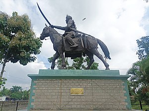
Statue of Meidingu Nara Singh
Monument in Imphal, India
Distance: Approx. 313 meters
Latitude and longitude: 24.8075,93.9387
The Statue of Meidingu Nara Singh, also known as the Statue of Maharaja Narasingh (Meitei: Meidingu Narasinghgi Mitam), is a bronze sculpture located at the Kangla Sanathong, the western entrance gate to the Kangla Fort in Imphal. Meidingu Nara Singh (1844-1850 A.D.) was a Meitei monarch and the sovereign of Kangleipak (Meitei for 'Manipur kingdom').

Kangla Sanathong
Western entrance gate to the Kangla Fort
Distance: Approx. 367 meters
Latitude and longitude: 24.807,93.939
The Kangla Sanathong (Meitei for 'The Royal Entrance to the Kangla'), also known as the Kangla Gate, is the western entrance gate to the Kangla Fort in Imphal West district of Kangleipak (Meitei for 'Manipur').

Pakhangba Temple, Kangla
Meitei temple inside the Kangla Fort
Distance: Approx. 326 meters
Latitude and longitude: 24.808,93.941
The Pakhangba Temple, also known as the Pakhangba Laishang (Meitei: ꯄꯥꯈꯪꯕ ꯂꯥꯏꯁꯪ, lit. 'Temple of God Pakhangba'), is a Meitei temple dedicated to the God Pakhangba of Sanamahism, the traditional Meitei religion, located beside the Nungseng Eekon, to the left side of the Kangla Sanathong, the western gate of the Kangla Fort in the Imphal West district of Manipur.

Manung Kangjeibung
Polo Ground located inside the Kangla fort in Imphal
Distance: Approx. 599 meters
Latitude and longitude: 24.8061,93.9427
The Manung Kangjeibung (Old Manipuri: Manung Kangcheipung) (Manung Kangjeibung (Meitei for 'Inner Pologround')) is an old polo field located to the south west of the citadel inside the Kangla Fort in Imphal West district of Manipur. In ancient times, only royalties and nobilities were allowed to play the game of polo (Meitei: Sagol Kangjei) in this royal playground. It is one of the two most ancient pologrounds in the world, the other one being the Mapal Kangjeibung (Imphal Polo Ground).
Weather in this IP's area
clear sky
18 Celsius
19 Celsius
18 Celsius
18 Celsius
1015 hPa
96 %
1015 hPa
927 hPa
10000 meters
1.34 m/s
1.33 m/s
28 degree
5 %
05:14:05
16:43:59