Country:
 Sweden
Region:
City:
Latitude and Longitude:
Time Zone:
Postal Code:
IP information under different IP Channel
ip-api
Country
Region
City
ASN
Time Zone
ISP
Blacklist
Proxy
Latitude
Longitude
Postal
Route
IPinfo
Country
Region
City
ASN
Time Zone
ISP
Blacklist
Proxy
Latitude
Longitude
Postal
Route
MaxMind
Country
Region
City
ASN
Time Zone
ISP
Blacklist
Proxy
Latitude
Longitude
Postal
Route
Luminati
Country
SERegion
ab
City
saltsjobaden
ASN
Time Zone
Europe/Stockholm
ISP
SECURITYSERVICES
Latitude
Longitude
Postal
db-ip
Country
Region
City
ASN
Time Zone
ISP
Blacklist
Proxy
Latitude
Longitude
Postal
Route
ipdata
Country
Region
City
ASN
Time Zone
ISP
Blacklist
Proxy
Latitude
Longitude
Postal
Route
Popular places and events near this IP address

Södra länken
Underground highway in Stockholm, Sweden
Distance: Approx. 1213 meters
Latitude and longitude: 59.29638889,18.05694444
Södra länken (The southern link), designated as national road 75 (Swedish: Riksväg 75), is a motorway in Sweden connecting Essingeleden (E4, E20), Stockholm with Värmdöleden (county road 222), Nacka. Södra länken is 6 km (3.7 mi) in length, of which 4.5 km (2.8 mi) is in tunnels. This makes it the third longest urban motorway tunnel in Europe after Madrid M30 orbital motorway and Blanka tunnel complex in Prague at 5.5 km (3.4 mi).

Stureby
Distance: Approx. 684 meters
Latitude and longitude: 59.28333333,18.05
Stureby () is a residential area in southern Stockholm, approx. 3 kilometers from Skanstull. The district at 205 hectares is bordered with Örby, Örby slott, Östberga, Årstafältet, Gamla Enskede, Svedmyra, Gubbängen and Bandhagen.

Gamla Enskede
Distance: Approx. 1166 meters
Latitude and longitude: 59.28451667,18.08147778
Gamla Enskede (Swedish: "Old Enskede") is a district of Enskede-Årsta-Vantör borough, South Stockholm, Sweden. In addition to housing areas, the district includes the Skogskyrkogården woodland cemetery and the smaller Sandsborgskyrkogården cemetery.

Göta highway
Historical road in Sweden
Distance: Approx. 1065 meters
Latitude and longitude: 59.292,18.047
Göta highway (Swedish: Göta landsväg) was, up to the late-17th century, the only road between Stockholm and south of Sweden. Dating back at least to the Middle Ages, and some parts even back to the Viking Age, the highway is the oldest known road from Stockholm to the south. Göta highway lost importance after the year 1670, when the new highway via Hornstull came in use.
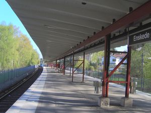
Enskede gård metro station
Stockholm Metro station
Distance: Approx. 644 meters
Latitude and longitude: 59.28888889,18.07055556
Enskede gård metro station is on the Green line of the Stockholm metro, located in Enskede gård, Söderort. The station was inaugurated on 1 October 1930 as part of the stretch between Gullmarsplan and Stureby. The distance to Slussen is 3.8 km.

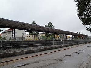
Svedmyra metro station
Stockholm Metro station
Distance: Approx. 974 meters
Latitude and longitude: 59.2775,18.06708333
Svedmyra metro station is on the Green line of the Stockholm metro, located in Stureby, Söderort. The station was inaugurated on 1 October 1930 as part of the stretch between Gullmarsplan and Stureby. The distance to Slussen is 5.2 km (3.2 mi).
Stureby metro station
Stockholm Metro station
Distance: Approx. 1245 meters
Latitude and longitude: 59.27472222,18.05694444
Stureby metro station is on the Green line of the Stockholm metro, located in Stureby, Söderort. The provisional station was inaugurated on 1 October 1930 as the southern terminus of the stretch from Gullmarsplan, and the current permanent station was inaugurated on 1 October 1953. On 22 November 1954, the extension south to Högdalen was open.

Sockenplan metro station
Stockholm Metro station
Distance: Approx. 615 meters
Latitude and longitude: 59.28277778,18.07027778
metro station is on the Green line of the Stockholm metro, located in Enskedefältet, Söderort. The station was inaugurated on 1 October 1930 as part of the stretch between Gullmarsplan and Stureby. The distance to Slussen is 4.6 km (2.9 mi).

Stureby murder
2009 child murder in Sweden
Distance: Approx. 523 meters
Latitude and longitude: 59.28166667,18.06583333
The Stureby murder occurred on the night between 6 and 7 June 2009, when 15-year-old Therese Johansson Rojo (born 17 June 1993) was strangled to death in Stureby, located outside of Stockholm, Sweden, by a 16-year-old schoolmate. The killer, who eventually admitted to the murder, and his girlfriend of the same age, who had conspired with him, were arrested the following day. The girl had convinced the boy via text messages, telephone calls and chat room contact to kill Therese during the weeks leading up to the murder.
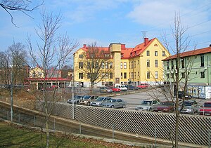
Enskede gård
Commune in Söderort, Stockholm, Sweden
Distance: Approx. 455 meters
Latitude and longitude: 59.28867778,18.06658889
Enskede gård is a commune in Söderort, Stockholm, Sweden. It is the site of the Enskede gård metro station. The headquarters of the Serbian Orthodox Eparchy of Britain and Scandinavia are located in Enskede gård.

Enskedefältet
Distance: Approx. 64 meters
Latitude and longitude: 59.285275,18.06186667
Enskedefältet is a community of Söderort in Stockholm, Sweden.

Saint Sava Serbian Orthodox Church, Stockholm
Church in Enskede gård, Sweden
Distance: Approx. 413 meters
Latitude and longitude: 59.2894,18.0617
The Saint Sava Serbian Orthodox Church (Swedish: Sankt Sava serbisk-ortodoxa kyrka; Serbian: Црква светог Саве, Crkva svetog Save) is a church building in Enskede gård in Stockholm, Sweden. It was taken into use in 1991 but not officially inaugurated until 5 October 2014. It is the cathedral church of the Serbian Orthodox Eparchy of Britain and Scandinavia.
Weather in this IP's area
clear sky
11 Celsius
11 Celsius
11 Celsius
12 Celsius
1032 hPa
96 %
1032 hPa
1029 hPa
9000 meters
0.51 m/s
10 %
06:26:01
18:57:01