Country:
 France
Region:
City:
Latitude and Longitude:
Time Zone:
Postal Code:
IP information under different IP Channel
ip-api
Country
Region
City
ASN
Time Zone
ISP
Blacklist
Proxy
Latitude
Longitude
Postal
Route
IPinfo
Country
Region
City
ASN
Time Zone
ISP
Blacklist
Proxy
Latitude
Longitude
Postal
Route
MaxMind
Country
Region
City
ASN
Time Zone
ISP
Blacklist
Proxy
Latitude
Longitude
Postal
Route
Luminati
Country
FRRegion
idf
City
puteaux
ASN
Time Zone
Europe/Paris
ISP
Electricite de France SA
Latitude
Longitude
Postal
db-ip
Country
Region
City
ASN
Time Zone
ISP
Blacklist
Proxy
Latitude
Longitude
Postal
Route
ipdata
Country
Region
City
ASN
Time Zone
ISP
Blacklist
Proxy
Latitude
Longitude
Postal
Route
Popular places and events near this IP address

Puteaux
Commune in Île-de-France, France
Distance: Approx. 732 meters
Latitude and longitude: 48.885,2.2389
Puteaux (French pronunciation: [pyto] ) is a commune in the western suburbs of Paris, France. It is located in the heart of the Hauts-de-Seine department, 8.7 kilometres (5.4 mi) from the centre of Paris. La Défense, Paris's business district hosting the tallest buildings in the metropolitan area, spreads over the northern part of Puteaux and parts of the neighbouring communes Courbevoie and Nanterre.

Tour Initiale
Office in La Défense
Distance: Approx. 889 meters
Latitude and longitude: 48.88694444,2.25138889
Tour Initiale (previously known as tour Nobel) is an office building located in La Défense business district just west of Paris, France. The 105 m (344 ft) Tour Initiale was the first office tower built in the La Défense district with its construction being completed in 1966. In 1988, the tower was given an internal renovation, and the new name of Tour Initiale.

Château de Bagatelle
Neoclassical estate in the Bois de Boulogne park of Paris, France
Distance: Approx. 937 meters
Latitude and longitude: 48.87166667,2.24722222
The Château de Bagatelle in Paris is a small Neoclassical-style château with several French formal gardens, a rose garden and an orangerie. It is set on 59 acres of grounds in French landscape style within the Bois de Boulogne, which is located in the 16th arrondissement of Paris. There are other châteaux named Bagatelle in France, including the Château de Bagatelle in Picardy and the Château de Bagatelle in Brittany.

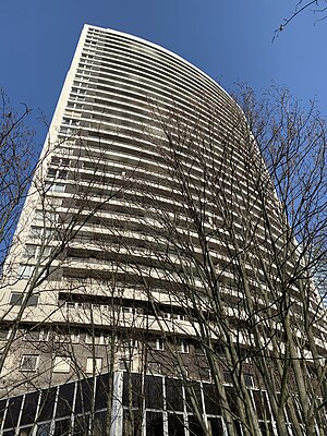
Tour France
Residential skyscraper in Puteaux, France
Distance: Approx. 378 meters
Latitude and longitude: 48.88305556,2.24763889
Tour France is a residential skyscraper located in La Défense business district and in Puteaux, France, west of Paris. Built in 1973, the tower is one of the tallest residential towers in France, with a height of 126 metres. The tower is located on the banks of the Seine and offers a panorama over the historical center of Paris.
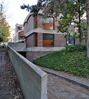
Maisons Jaoul
Houses by Le Corbusier in Paris
Distance: Approx. 630 meters
Latitude and longitude: 48.88,2.254
Maisons Jaoul are a celebrated pair of houses in the upmarket Paris suburb of Neuilly-sur-Seine, designed by Le Corbusier and built in 1954–56. They are among his most important post-war buildings and feature a rugged aesthetic of unpainted cast concrete "béton brut" and roughly detailed brickwork.

Puteaux station
Distance: Approx. 952 meters
Latitude and longitude: 48.88361111,2.23361111
Puteaux is a railway station in the town Puteaux, Hauts-de-Seine department, in the western suburbs of Paris, France. The station originally opened on 18 July 1840, as part of the Paris to St Cloud and Versailles railway.
Villa Windsor
Building in Paris, France
Distance: Approx. 820 meters
Latitude and longitude: 48.8742,2.2523
4 route du Champ d'Entraînement, also known as Villa Windsor, is a historic villa in the 16th arrondissement of Paris, France. It is located within the northwest section of the Bois de Boulogne, close to the southern edge of Neuilly-sur-Seine. It was the main residence of the Duke and Duchess of Windsor from 1953 until the Duke's death in 1972, and the Duchess continued to live there until she died in 1986.
École nationale d'assurances
Distance: Approx. 955 meters
Latitude and longitude: 48.8872,2.2383
L'École Nationale d'assurances or "French National School of Insurance" is an institute associated with the French Conservatoire National des Arts et Métiers, which delivers diplomas in the insurance field: Bachelor of Arts, Master of Arts, and Master of Business Administration for executives.
Tour Ève
Commercial offices & apartments in Puteaux, France
Distance: Approx. 916 meters
Latitude and longitude: 48.8878445,2.2416012
Tour Ève (previously known as Tour PH21) is an office and apartments skyscraper in Puteaux, in La Défense, the business district of the Paris metropolitan area. Built in 1974, this 109 m skyscraper belongs to the second generation of skyscrapers in La Défense. It is also the 4th tallest residential building in the business district, after the Tour Les Poissons, the Tour Défense 2000 and the Tour France.

Tour Michelet
Commercial offices in Puteaux, France
Distance: Approx. 916 meters
Latitude and longitude: 48.8882305,2.2452229
Tour Michelet is an office skyscraper in Puteaux, in La Défense, the business district of the Paris metropolitan area. It notably hosts the company Total. When it was completed in 1985, the 127 meter high office tower was the ninth tallest in the La Défense business district.

Tour Eria
Skyscraper in La Défense's Puteaux
Distance: Approx. 781 meters
Latitude and longitude: 48.88637924,2.24984837
Tour Eria is a skyscraper of offices, shops and other activities located in the business district of La Défense near Paris, France (precisely in Puteaux). Built in 2021, it takes over from the Tour Arago destroyed in 2017. In particular, it will host in September 2021 the "Campus Cyber" decided by the President of the Republic Emmanuel Macron and also training activities in cybersecurity.
Neuilly kindergarten hostage crisis
1993 hostage crisis in France
Distance: Approx. 676 meters
Latitude and longitude: 48.8772,2.2536
The Neuilly kindergarten hostage crisis took place from 13–15 May 1993, when Érick Schmitt (calling himself the "Human Bomb"), a depressed and unemployed businessman, held a kindergarten class in Neuilly-sur-Seine, France, hostage for two days. He was armed with a flare gun and strapped with explosives, and was eventually killed on 15 May during a RAID assault. There were no other casualties.
Weather in this IP's area
overcast clouds
14 Celsius
14 Celsius
13 Celsius
15 Celsius
1010 hPa
91 %
1010 hPa
1007 hPa
10000 meters
5.66 m/s
200 degree
100 %
07:18:11
20:19:23