Country:
 Malaysia
Region:
City:
Latitude and Longitude:
Time Zone:
Postal Code:
IP information under different IP Channel
ip-api
Country
Region
City
ASN
Time Zone
ISP
Blacklist
Proxy
Latitude
Longitude
Postal
Route
IPinfo
Country
Region
City
ASN
Time Zone
ISP
Blacklist
Proxy
Latitude
Longitude
Postal
Route
MaxMind
Country
Region
City
ASN
Time Zone
ISP
Blacklist
Proxy
Latitude
Longitude
Postal
Route
Luminati
Country
MYASN
Time Zone
Asia/Kuching
ISP
Viewqwest Pte Ltd
Latitude
Longitude
Postal
db-ip
Country
Region
City
ASN
Time Zone
ISP
Blacklist
Proxy
Latitude
Longitude
Postal
Route
ipdata
Country
Region
City
ASN
Time Zone
ISP
Blacklist
Proxy
Latitude
Longitude
Postal
Route
Popular places and events near this IP address
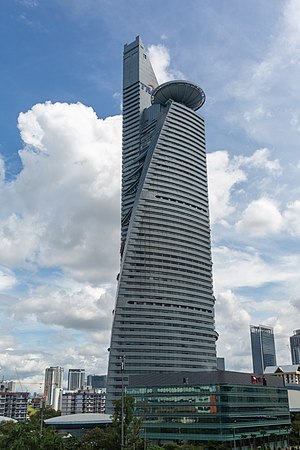
Telekom Tower
Supertall skyscraper in Kuala Lumpur, Malaysia
Distance: Approx. 387 meters
Latitude and longitude: 3.11583056,101.66611111
Telekom Tower (Malay: Menara Telekom; Jawi: منارا تيليکوم), also known as TM Tower is a 55-storey, 310-meter-tall supertall skyscraper in Lembah Pantai in western Kuala Lumpur, Malaysia and was the former headquarters of Malaysian telecommunications company, Telekom Malaysia until 2023. It is the world's 4th tallest twisted building. It is Malaysia's 5th tallest building, and is shaped to represent a sprouting "bamboo shoot".

Mid Valley Megamall
Shopping mall in Kuala Lumpur, Malaysia
Distance: Approx. 1121 meters
Latitude and longitude: 3.11805556,101.67666667
Mid Valley Megamall is a shopping mall in Mid Valley City, Kuala Lumpur, Malaysia. It sits at the entrance of Petaling Jaya and Kuala Lumpur. Developed by IGB Berhad, the complex was opened in 1999.

Radio Televisyen Malaysia
Public broadcaster of Malaysia
Distance: Approx. 345 meters
Latitude and longitude: 3.11111111,101.67052778
Radio Televisyen Malaysia (English: Radio Television of Malaysia, Jawi: راديو تيليۏيشن مليسيا; abbreviated as RTM, stylised as rtm), also known as the Department of Broadcasting, Malaysia (Malay: Jabatan Penyiaran Malaysia; Jawi: جابتن ڤڽيارن مليسيا) is the national public broadcaster of Malaysia, headquartered at Angkasapuri, Kuala Lumpur. Established on 1 April 1946 as Radio Malaya, it is the first and the oldest broadcaster in the country. After Malaysia was formed on 16 September 1963, Radio Malaya was renamed Radio Malaysia.

Kerinchi Pylon
Transmission tower in Kerinchi, Kuala Lumpur, Malaysia
Distance: Approx. 652 meters
Latitude and longitude: 3.1169,101.6637
The Kerinchi Pylon is a lattice-steel transmission tower located near Menara Telekom in Kerinchi, Kuala Lumpur, Malaysia. It was built by Tenaga Nasional Berhad (TNB) in the middle of 1999. At 103 metres (338 ft), the pylon is recorded in the Malaysian Book of Records as the tallest electricity pylon in Southeast Asia.
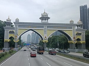
Kota Darul Ehsan
Arch on the border of Kuala Lumpur and Selangor in Malaysia
Distance: Approx. 1273 meters
Latitude and longitude: 3.11227778,101.65656944
Kota Darul Ehsan is a row of arches symbolizing the border on Malaysian Federal Highway between the Federal Territory of Kuala Lumpur and Malaysian state of Selangor. Erected on Federal Route 2, it is the biggest arch in Malaysia.
Lembah Pantai
Place
Distance: Approx. 373 meters
Latitude and longitude: 3.11111111,101.67083333
Lembah Pantai is a sub-district and parliamentary constituency in south-western Kuala Lumpur, Malaysia. Constituencies adjacent to Lembah Pantai are Seputeh, Segambut and Bukit Bintang. The total number of population is 148,094 as of 2020 census.

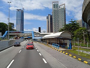
Kerinchi LRT station
Rail station in Kuala Lumpur, Malaysia
Distance: Approx. 264 meters
Latitude and longitude: 3.11527778,101.66805556
The Kerinchi LRT station is a Kelana Jaya LRT station in Kuala Lumpur. The station, which is named after Kampung Kerinchi, a village within walking distance, is located inside Plaza Pantai (officially being redeveloped as Bangsar Trade Centre), a mixed commercial complex near Jalan Pantai Baru. The station is linked to Bangsar South Trade Centre by an 800m long pedestrian bridge spanning across the Federal Highway.

Universiti LRT station
LRT station in Kuala Lumpur
Distance: Approx. 724 meters
Latitude and longitude: 3.11444444,101.66166667
Universiti is a light rapid transit (LRT) station in Kuala Lumpur served by the Kelana Jaya Line. The station is planned as a future interchange with the upcoming MRT Circle Line of the KVMRT project.
Angkasapuri Komuter station
Railway station in Kuala Lumpur, Malaysia
Distance: Approx. 593 meters
Latitude and longitude: 3.11305556,101.67333333
The Angkasapuri Komuter station is a KTM Komuter train station located near Angkasapuri, Kuala Lumpur. It is served by the Port Klang Line. The station primarily serves and is named after Angkasapuri, the headquarters of RTM. Located nearby are the Sri Damesh private school and the neighbourhoods of Pantai Dalam and Kampung Kerinchi.
Mid Valley City
Distance: Approx. 1131 meters
Latitude and longitude: 3.117933,101.676847
Mid Valley City is a large mixed development in the Lembah Pantai ward in southwestern Kuala Lumpur, Malaysia. The development consists of The Gardens shopping mall, Mid Valley Megamall and three hotels, namely the Cititel Mid Valley, The Boulevard Hotel Kuala Lumpur and the Gardens Hotels and Residences.

KL Eco City
Mixed Development in Kuala Lumpur in Malaysia
Distance: Approx. 870 meters
Latitude and longitude: 3.11805556,101.67388889
KL Eco City, or KLEC for short, is a 25-acre integrated mixed-use development project in the city of Kuala Lumpur, Malaysia. The project is built at the site of former Haji Abdullah Hukum Village. The mixed development project is helmed by S P Setia Berhad under a joint-venture agreement with the Kuala Lumpur City Hall (DBKL).

Al-Rahman Mosque, Kuala Lumpur
Mosque in Kuala Lumpur, Malaysia
Distance: Approx. 862 meters
Latitude and longitude: 3.11858333,101.66272222
The Al-Rahman Mosque (Malay: Masjid Al-Rahman) is a mosque in Kuala Lumpur, Malaysia. The mosque is located at University of Malaya in Jalan Pantai Baharu and was named after the first Malaysian Prime Minister, Tunku Abdul Rahman Putra Al-Haj. Today, the mosque is joint managed by University of Malaya and the Department of Federal Territory Islamic Affairs (JAWI).
Weather in this IP's area
overcast clouds
29 Celsius
34 Celsius
28 Celsius
29 Celsius
1009 hPa
78 %
1009 hPa
1004 hPa
10000 meters
1.23 m/s
1.5 m/s
161 degree
99 %
07:06:37
19:15:46