Country:
 USA
USARegion:
City:
Latitude and Longitude:
Time Zone:
Postal Code:
IP information under different IP Channel
ip-api
Country
Region
City
ASN
Time Zone
ISP
Blacklist
Proxy
Latitude
Longitude
Postal
Route
IPinfo
Country
Region
City
ASN
Time Zone
ISP
Blacklist
Proxy
Latitude
Longitude
Postal
Route
MaxMind
Country
Region
City
ASN
Time Zone
ISP
Blacklist
Proxy
Latitude
Longitude
Postal
Route
Luminati
Country
USASN
Time Zone
America/Chicago
ISP
13445
Latitude
Longitude
Postal
db-ip
Country
Region
City
ASN
Time Zone
ISP
Blacklist
Proxy
Latitude
Longitude
Postal
Route
ipdata
Country
Region
City
ASN
Time Zone
ISP
Blacklist
Proxy
Latitude
Longitude
Postal
Route
Popular places and events near this IP address

River Oaks station
VTA light rail station in San Jose, California
Distance: Approx. 1446 meters
Latitude and longitude: 37.40217,-121.939649
River Oaks station is an at-grade light rail station located in the center median of First Street at its intersection with River Oaks Parkway, after which the station is named, in San Jose, California. The station is owned by Santa Clara Valley Transportation Authority (VTA) and is served by the Blue Line and the Green Line of the VTA light rail system.

Champion station
VTA light rail station in San Jose, California
Distance: Approx. 179 meters
Latitude and longitude: 37.40916667,-121.95222222
Champion station is an at-grade light rail station on the Green Line and the Orange Line of the VTA light rail system. The station is located in the center median of Tasman Drive just east of its intersection with Champion Court, after which the station is named. This station is the furthest east on the section of track shared by the Green and Orange lines.

Lick Mill station
VTA light rail station in Santa Clara, California
Distance: Approx. 829 meters
Latitude and longitude: 37.407699,-121.963338
Lick Mill station is a light rail station operated by Santa Clara Valley Transportation Authority (VTA). Lick Mill is served by the Orange and Green light rail lines. Lick Mill is VTA's recommended transfer point for Altamont Corridor Express (ACE) commuter rail and Capitol Corridor inter-city rail trains at Santa Clara – Great America station.

Tasman station
VTA light rail station in San Jose, California
Distance: Approx. 865 meters
Latitude and longitude: 37.408372,-121.944219
Tasman station is an at-grade light rail station located in the center median of First Street at its intersection with Tasman Drive, after which the station is named, in San Jose, California. The station is owned by Santa Clara Valley Transportation Authority (VTA) and is served by the Blue Line and the Green Line of the VTA light rail system. This is the northernmost station served by both the Blue and Green lines and serves as one of the primary transfer points between the two lines.

Baypointe station
VTA light rail station in San Jose, California
Distance: Approx. 1098 meters
Latitude and longitude: 37.410664,-121.941912
Baypointe station is an at-grade light rail station located in the center median of Tasman Drive at its intersection with Baypointe Parkway, after which the station is named, in San Jose, California. The station is owned by Santa Clara Valley Transportation Authority (VTA) and is served by the Blue Line and the Orange Line of the VTA light rail system. Baypointe station is the current northern terminus for the Blue Line.

Rivermark of Santa Clara
Planned community in Santa Clara
Distance: Approx. 1166 meters
Latitude and longitude: 37.39805556,-121.95194444
Rivermark of Santa Clara is a master-planned community in Santa Clara, California, built on a 152-acre (0.62 km2) parcel formerly owned by the State of California and previously used by Agnews Developmental Center. The community comprises retail space, parks, school, library, apartments, condominiums, townhouses, and houses (detached single-family homes). The Rivermark neighborhood has been described as "upscale," with many young professionals and families as residents.
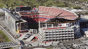
Levi's Stadium
Football stadium in California, U.S.
Distance: Approx. 1537 meters
Latitude and longitude: 37.403,-121.97
Levi's Stadium is an American football stadium located in Santa Clara, California, just west of the much larger city of San Jose, in the San Francisco Bay Area. It has served as the home venue for the National Football League (NFL)'s San Francisco 49ers since 2014. The stadium is located approximately 40 miles (64 km) south of San Francisco.

James Lick Mansion
Historic house in California, United States
Distance: Approx. 1372 meters
Latitude and longitude: 37.39969722,-121.94301944
The James Lick Mansion, in Santa Clara, California, United States, is the estate of James Lick, who was the richest man in California at the time of his death in 1876. The estate is listed on the National Register of Historic Places. This property was once part of the Rancho Ulistac land grant, a square league reaching from the Alviso shoreline southward and encompassing all the land between the Guadalupe River and Saratoga Creek.

Santa Clara–Great America station
Railway station in Santa Clara, California
Distance: Approx. 1156 meters
Latitude and longitude: 37.406645,-121.96688
Santa Clara–Great America station (called Great America station by ACE) is a train station in Santa Clara, California. It hosts Amtrak's Capitol Corridor trains and Altamont Corridor Express (ACE) trains. The station is close to Levi's Stadium and California's Great America.

University of Silicon Valley
For-profit university in San Jose, California
Distance: Approx. 1286 meters
Latitude and longitude: 37.413627,-121.941034
The University of Silicon Valley (USV) is a private for-profit university in San Jose, California, in Silicon Valley. Founded in 1887 as Cogswell Technical School, and later known as Cogswell Polytechnical College. It was the first technical training institution in the Western United States and one of only two private universities, along with Stanford University, that were originally guaranteed a tax exemption in the Californian Constitution.
Anything's Possible
Public artwork in Santa Clara, California, USA
Distance: Approx. 1602 meters
Latitude and longitude: 37.4044,-121.9714
Anything's Possible is a public artwork by artist Linda Serrao, located by Levi's Stadium in Santa Clara, CA, United States. Anything's Possible is an installation of two over-lifesize bronze figures, commissioned by the City of Santa Clara. The installation depicts a 7' Quarterback preparing to pass the football to a young fan.
Second Harvest of Silicon Valley
Food bank in California, US
Distance: Approx. 520 meters
Latitude and longitude: 37.41277778,-121.95194444
Second Harvest of Silicon Valley (abbreviated SHSV) is a food bank based in San Jose, California, that serves Santa Clara and San Mateo counties, including Silicon Valley and the San Francisco Peninsula. With $136 million in revenue in 2019, it is the largest food bank in the San Francisco Bay Area and the 12th largest in the United States. As of 2020, it serves about 500,000 people on average per month.
Weather in this IP's area
overcast clouds
20 Celsius
20 Celsius
17 Celsius
21 Celsius
1011 hPa
59 %
1011 hPa
1011 hPa
10000 meters
2.57 m/s
340 degree
100 %
06:51:11
19:13:55