162.6.41.36 - IP Lookup: Free IP Address Lookup, Postal Code Lookup, IP Location Lookup, IP ASN, Public IP
Country:
Region:
City:
Location:
Time Zone:
Postal Code:
ISP:
ASN:
language:
User-Agent:
Proxy IP:
Blacklist:
IP information under different IP Channel
ip-api
Country
Region
City
ASN
Time Zone
ISP
Blacklist
Proxy
Latitude
Longitude
Postal
Route
db-ip
Country
Region
City
ASN
Time Zone
ISP
Blacklist
Proxy
Latitude
Longitude
Postal
Route
IPinfo
Country
Region
City
ASN
Time Zone
ISP
Blacklist
Proxy
Latitude
Longitude
Postal
Route
IP2Location
162.6.41.36Country
Region
virginia
City
falls church
Time Zone
America/New_York
ISP
Language
User-Agent
Latitude
Longitude
Postal
ipdata
Country
Region
City
ASN
Time Zone
ISP
Blacklist
Proxy
Latitude
Longitude
Postal
Route
Popular places and events near this IP address

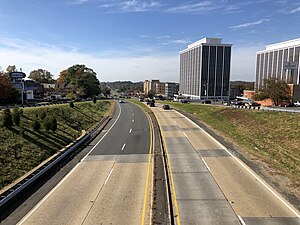
West Falls Church, Virginia
Census-designated place in Virginia, United States
Distance: Approx. 479 meters
Latitude and longitude: 38.86555556,-77.18777778
West Falls Church is a census-designated place (CDP) in Fairfax County, Virginia, United States. The population was 29,207 at the 2010 census. Before 2010, West Falls Church was officially named Jefferson (from Thomas Jefferson).

Falls Church High School
High school in Falls Church, Virginia, United States
Distance: Approx. 1208 meters
Latitude and longitude: 38.86222222,-77.20666667
Falls Church High School (FCHS) is a high school located in West Falls Church, Virginia, in unincorporated Fairfax County. While the school has a Falls Church mailing address, the school does not serve the City of Falls Church, which is served by Meridian High School. The school serves grades 9 through 12.

Trinity School at Meadow View
Private christian school
Distance: Approx. 1521 meters
Latitude and longitude: 38.87388889,-77.20694444
Trinity School at Meadow View is a private, Blue Ribbon Award-winning Christian school in Falls Church, Virginia. It was founded in 1998 by the People of Praise and provides classical Christian education to students in grades 7-12. Since then it has developed a strong educational presence in Northern Virginia and attracts international students.

Holmes Run Acres
United States historic place
Distance: Approx. 2145 meters
Latitude and longitude: 38.85,-77.20833333
Holmes Run Acres is a community of 355 houses in Fairfax County, Virginia, in the Washington, D.C. suburbs. Nearly all of the neighborhood is within the Holmes Run Acres Historic District, listed on the National Register of Historic Places. The first Fairfax County subdivision designed by architects Nicholas Satterlee and Francis D. Lethbridge, Holmes Run Acres influenced the architecture and site planning at nearby Pine Spring and elsewhere, including the Potomac Overlook and Carderock Springs historic districts in Montgomery County, Maryland.
JV's Restaurant
Distance: Approx. 1682 meters
Latitude and longitude: 38.87033333,-77.175
Founded in October 1947, JV's Restaurant is a Falls Church and Fairfax County, Virginia restaurant and live music venue. Located on Arlington Boulevard, Route 50, just west of Annandale Road, JV's has provided live music for more than four decades. In 2004, the Washington Area Music Association presented JV's with the Special Appreciation Award, voted on by participating Washington-region musicians, as their favorite live venue.

The Falls Church Anglican
Church in Virginia, United States
Distance: Approx. 1985 meters
Latitude and longitude: 38.86972222,-77.17111111
The Falls Church Anglican is an Anglican parish in the Falls Church section of Fairfax County, Virginia, near Washington, D.C. In 2006, the congregation of the Falls Church divided over the question of whether to leave the Episcopal Church, effectively creating two congregations: the Falls Church Anglican and the Falls Church. Following years of conflict within the Episcopal Church over issues surrounding Biblical authority and interpretation (including issues such as human sexuality, the role of men and women in ordained ministry, and liturgical reform) several congregations within the Episcopal Church concluded that the only way for them to remain faithful to their views was to "walk apart" from the Episcopal Church, yet remain in communion with other Anglican churches. The Falls Church was one of these congregations.
Sleepy Hollow, Virginia
Unincorporated community in Virginia, United States
Distance: Approx. 2486 meters
Latitude and longitude: 38.86722222,-77.16472222
Sleepy Hollow is an unincorporated community in Fairfax County, Virginia, United States. Sleepy Hollow is 1.1 miles (1.8 km) south-southeast of Falls Church.
Big Chimneys
Distance: Approx. 2486 meters
Latitude and longitude: 38.88237778,-77.17481667
Big Chimneys Park is located in Falls Church, Virginia. It marks the site of a log house built in 1699. It is located on Annandale Road about a block west of Maple Avenue.

Mount Hope (Falls Church, Virginia)
Historic house in Virginia, United States
Distance: Approx. 2498 meters
Latitude and longitude: 38.88583333,-77.18166667
Mount Hope is a historic home located at Falls Church, Virginia. It was built in the 1830s, as a 1+1⁄2-story, frame I-house dwelling. It consists of three parts: a frame dwelling built about 1830; a 2+1⁄2-story, 3-bay, Gothic Revival brick dwelling built in 1869; and a 1-bay brick section that joins the two.

Fountain of Faith
Distance: Approx. 1542 meters
Latitude and longitude: 38.878,-77.2004
The Fountain of Faith is a monumental sculptural group by Carl Milles in Falls Church, Virginia. It is located in National Memorial Park, a large cemetery which also displays a colossal cast of Milles' Sunsinger sculpture. Each of the fountain's thirty-seven life-size bronze figures evokes a specific individual whom Milles had known before their death.

National Memorial Park
Cemetery in Virginia
Distance: Approx. 1683 meters
Latitude and longitude: 38.87861111,-77.2025
National Memorial Park is a cemetery in the Washington, D.C. suburb of Falls Church, Virginia. The cemetery is part of the National Funeral Home and National Memorial Park complex, which includes several related memorial and end-of-life services. The cemetery covers 168 acres, lined with fountains, trees, gardens, and sculptures.
2941 Restaurant
Restaurant in Falls Church, Virginia, U.S.
Distance: Approx. 1957 meters
Latitude and longitude: 38.869604,-77.215187
2941 Restaurant, or simply 2941, is a fine dining restaurant in Falls Church, Virginia. In 2024, 2941 Restaurant was a semifinalist in the Outstanding Restaurant category of the James Beard Foundation Awards.
Weather in this IP's area
scattered clouds
-3 Celsius
-3 Celsius
-6 Celsius
-2 Celsius
1021 hPa
74 %
1021 hPa
1011 hPa
10000 meters
0.89 m/s
0.89 m/s
307 degree
40 %