Country:
 USA
USARegion:
City:
Latitude and Longitude:
Time Zone:
Postal Code:
IP information under different IP Channel
ip-api
Country
Region
City
ASN
Time Zone
ISP
Blacklist
Proxy
Latitude
Longitude
Postal
Route
IPinfo
Country
Region
City
ASN
Time Zone
ISP
Blacklist
Proxy
Latitude
Longitude
Postal
Route
MaxMind
Country
Region
City
ASN
Time Zone
ISP
Blacklist
Proxy
Latitude
Longitude
Postal
Route
Luminati
Country
USRegion
ia
City
cedarrapids
ASN
Time Zone
America/Chicago
ISP
IMONC
Latitude
Longitude
Postal
db-ip
Country
Region
City
ASN
Time Zone
ISP
Blacklist
Proxy
Latitude
Longitude
Postal
Route
ipdata
Country
Region
City
ASN
Time Zone
ISP
Blacklist
Proxy
Latitude
Longitude
Postal
Route
Popular places and events near this IP address

USS Halsey Powell
Fletcher-class destroyer
Distance: Approx. 1858 meters
Latitude and longitude: 41.967025,-91.687683
USS Halsey Powell (DD-686), was a Fletcher-class destroyer of the United States Navy.

ImOn Ice Arena
Multipurpose arena in Cedar Rapids, Iowa, United States
Distance: Approx. 1720 meters
Latitude and longitude: 41.96583,-91.688559
The ImOn Ice Arena is a 3,850-seat multipurpose arena in Cedar Rapids, Iowa, located adjacent to Veterans Memorial Stadium. The arena opened on January 8, 2000, and is owned by the city of Cedar Rapids. It is home to the Cedar Rapids RoughRiders of the United States Hockey League as well as several local youth hockey teams.

Veterans Memorial Stadium (Cedar Rapids)
Distance: Approx. 1984 meters
Latitude and longitude: 41.96805556,-91.68638889
Veterans Memorial Stadium is a minor league baseball stadium in Cedar Rapids, Iowa. It is the home field of the Cedar Rapids Kernels of the Midwest League. It is often called New Veterans Memorial Stadium to distinguish it from the original Veterans Memorial Stadium, which existed from 1949 to 2001.

Hamilton College (Iowa)
Distance: Approx. 1977 meters
Latitude and longitude: 41.94952778,-91.71354444
Hamilton College was the DBA name of the Iowa College Acquisition Corporation, a company that owns and operates independent for-profit colleges. Hamilton College had seven campuses in Iowa and Nebraska. Iowa College Acquisition Corporation is owned and operated by Kaplan Higher Education, a subsidiary of the Washington Post Company.
Westdale Mall
Shopping mall in Iowa, United States
Distance: Approx. 2515 meters
Latitude and longitude: 41.952,-91.72
Westdale Mall was an enclosed super-regional shopping mall in Cedar Rapids, Iowa, United States. The two-level mall on the southwest side of Cedar Rapids is one of the city's two enclosed malls, along with Lindale Mall on the city's northeast side. By 2012, Westdale displayed some characteristics of a dead mall as two of its four anchor stores and an estimated 70 percent of inline stores have been vacated as of January 2013.
Jefferson High School (Iowa)
Public secondary school in Cedar Rapids, Iowa, United States
Distance: Approx. 1766 meters
Latitude and longitude: 41.965,-91.69805556
Thomas Jefferson High School is a public high school in Cedar Rapids, Iowa. It is the eighth largest high school in Iowa. The school's mascot is Jeffy the J-Hawk and the official school colors are Columbia Blue and white.
Cedar Rapids Public Library
Distance: Approx. 2379 meters
Latitude and longitude: 41.952833,-91.718248
The Cedar Rapids Public Library (CRPL) serves the city of Cedar Rapids, Iowa. It consists of two locations: the Ladd Library, located at 3750 Williams Blvd SW, and the Downtown Library, located at 450 5th Avenue SE. The CRPL works in cooperation with the Marion Public Library and Hiawatha Public Library to form the Metro Library Network, which allows them to share a collection of materials, partner on programs, and make resources more available to all citizens. The Iowa flood of 2008, considered by the Federal Emergency Management Agency (FEMA) to be "one of the worst and most costly floods in Iowa--and even U.S. history," destroyed the building at the previous downtown location of the main branch, along with over half of the library's collection.

Lustron Home No. 02102
Historic house in Iowa, United States
Distance: Approx. 2454 meters
Latitude and longitude: 41.97083333,-91.70083333
The Lustron Home No. 02102 is a historic enameled steel prefabricated Lustron house located in Cedar Rapids, Iowa. It was listed on the National Register of Historic Places in 2004.

Cedar Rapids Community School District
School district in Cedar Rapids, Iowa, United States
Distance: Approx. 2027 meters
Latitude and longitude: 41.968597,-91.690694
The Cedar Rapids Community School District (CRCSD) is a public school district located in Cedar Rapids, Iowa. It has the second largest enrollment in the state of Iowa. The district has 21 elementary schools, 6 middle schools, 4 high schools, and 1 alternative high school.

Grant Vocational High School
United States historic place
Distance: Approx. 2850 meters
Latitude and longitude: 41.97425,-91.67716667
Grant Vocational High School, also known as the Board of Education and the Cedar Rapids School District Central Office, is a historic building located in Cedar Rapids, Iowa, United States. Completed in 1915, this is a rare example of a vocational high school in Iowa as only a handful were ever built. While it offered various student activities in athletics and the arts, its curriculum was based on the manual arts instead of humanities or college preparatory courses.
Kingston Stadium
Distance: Approx. 1894 meters
Latitude and longitude: 41.96741111,-91.69011389
Kingston Stadium is a football stadium in Cedar Rapids, Iowa. Kingston Stadium is located southwest of downtown Cedar Rapids, adjacent to Veterans Memorial Stadium and ImOn Ice Arena. Opened September 12, 1952, it was named for a settlement called Kingston established in 1839 on the west side of the Cedar River which was later annexed into Cedar Rapids.
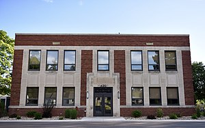
Iowa State Highway Commission, District 6 Building
Historic building in Iowa, United States
Distance: Approx. 1741 meters
Latitude and longitude: 41.96219444,-91.67588889
Iowa State Highway Commission, District 6 Building, also known as Iowa Department of Transportation building, is a historic building located in Cedar Rapids, Iowa, United States. It is significant for its association with the Iowa Highway Commission and its role developing policy and designing and implementing highway construction projects. It is also significant for its association with the New Deal program, the Public Works Administration.
Weather in this IP's area
scattered clouds
31 Celsius
33 Celsius
30 Celsius
32 Celsius
1010 hPa
55 %
1010 hPa
984 hPa
10000 meters
5.66 m/s
10.29 m/s
170 degree
40 %
06:51:34
19:09:15