162.252.134.4 - IP Lookup: Free IP Address Lookup, Postal Code Lookup, IP Location Lookup, IP ASN, Public IP
Country:
Region:
City:
Location:
Time Zone:
Postal Code:
IP information under different IP Channel
ip-api
Country
Region
City
ASN
Time Zone
ISP
Blacklist
Proxy
Latitude
Longitude
Postal
Route
Luminati
Country
Region
nb
City
dieppe
ASN
Time Zone
America/Moncton
ISP
PNB-TRANSIT
Latitude
Longitude
Postal
IPinfo
Country
Region
City
ASN
Time Zone
ISP
Blacklist
Proxy
Latitude
Longitude
Postal
Route
IP2Location
162.252.134.4Country
Region
new brunswick
City
campbellton
Time Zone
America/Moncton
ISP
Language
User-Agent
Latitude
Longitude
Postal
db-ip
Country
Region
City
ASN
Time Zone
ISP
Blacklist
Proxy
Latitude
Longitude
Postal
Route
ipdata
Country
Region
City
ASN
Time Zone
ISP
Blacklist
Proxy
Latitude
Longitude
Postal
Route
Popular places and events near this IP address

Campbellton, New Brunswick
City in New Brunswick, Canada
Distance: Approx. 3860 meters
Latitude and longitude: 48.005,-66.67305556
Campbellton is a city in Restigouche County, New Brunswick, Canada. Situated on the south bank of the Restigouche River opposite Pointe-à-la-Croix, Quebec, Campbellton was officially incorporated in 1889 and achieved city status in 1958. Forestry and tourism are major industries in the regional economy, while a pulp mill in the Campbellton community of Atholville is the largest single employer in the area.

Listuguj Mi'gmaq First Nation
Indian reserve in Quebec, Canada
Distance: Approx. 3779 meters
Latitude and longitude: 48.013005,-66.7051
The Listuguj Mi'gmaq First Nation (French: Première Nation de Listuguj Mi'gmaq) (in Francis-Smith orthography Listukuj Míkmaq) is a Mi'gmaq First Nations band government with a registered population (2022) of 4,248 members, most of whom are of Mi'kmaq ancestry. The name Listuguj, is the origin for the name of the Restigouche River, as well as other nearby places also carrying the name Restigouche. Listuguj is also used as a name for one of the Míkmaq orthographies.
Campbellton-Restigouche Centre
Defunct provincial electoral district in New Brunswick, Canada
Distance: Approx. 2560 meters
Latitude and longitude: 47.974,-66.741
Campbellton-Restigouche Centre was a provincial electoral district for the Legislative Assembly of New Brunswick, Canada. The riding was created as Campbellton in the 1967 redistribution when cities were removed from county districts and is made up of the City of Campbellton and the villages of Tide Head and Atholville and their surrounding areas. It returned one member from its inception and was unchanged in the 1973 redistribution when New Brunswick moved exclusively to single member districts.
Sugarloaf Senior High School
High school in Campbellton, New Brunswick, Canada
Distance: Approx. 3231 meters
Latitude and longitude: 47.998611,-66.67539
Sugarloaf Senior High School is an English high school, with French immersion, located in Campbellton, New Brunswick, Canada. Its name comes from the nearby Sugarloaf mountain, a local landmark adjacent to the provincial park of the same name.

J. C. Van Horne Bridge
Bridge in Quebec, Listuguj Miꞌgmaq First Nation
Distance: Approx. 4095 meters
Latitude and longitude: 48.01125556,-66.68078889
The J. C. Van Horne Bridge is a Canadian steel through truss/steel deck truss bridge crossing the Restigouche River between Campbellton, New Brunswick, and Pointe-à-la-Croix, Quebec. Built between June 1958 and October 1961, the bridge was opened to traffic on October 15, 1961. As an interprovincial crossing, the bridge was constructed under a three-party agreement between the governments of Canada, New Brunswick, and Quebec.

Atholville, New Brunswick
Community within the City of Campbellton
Distance: Approx. 1210 meters
Latitude and longitude: 47.98944444,-66.7125
Atholville is a community in Restigouche County, New Brunswick, Canada. It held village status prior to 2023 but is now part of the city of Campbellton. The first inhabitants of the area were the Mi'kmaq who settled there in the 6th century BC and were then called Tjikog.

Sugarloaf Mountain (New Brunswick)
Mountain in New Brunswick, Canada
Distance: Approx. 2018 meters
Latitude and longitude: 47.98972222,-66.68555556
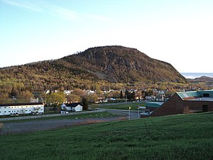
Sugarloaf Mountain is a 281.1 m (922 ft) mountain in the northern Appalachian Mountains in Campbellton, New Brunswick, Canada. The mountain is protected by Sugarloaf Provincial Park and lies within city limits, just south of the urban area.

Campbellton station
Railway station in New Brunswick, Canada
Distance: Approx. 3447 meters
Latitude and longitude: 48.004,-66.68
Campbellton station is located on Roseberry Street near the end of Shannon Street in the city of Campbellton, New Brunswick, Canada. The station is staffed and is wheelchair-accessible. Campbellton is served by Via Rail's Montreal-Halifax train, the Ocean.

Sugarloaf Provincial Park
Provincial Park in Campbellton, New Brunswick, Canada
Distance: Approx. 2602 meters
Latitude and longitude: 47.97666667,-66.67277778
Sugarloaf Provincial Park is an 11.5-square-kilometre (4.4 sq mi) all-season provincial park located in the Campbellton community of Atholville. It opened in 1972.
Val-d'Amour, New Brunswick
Unincorporated community in New Brunswick, Canada
Distance: Approx. 3833 meters
Latitude and longitude: 47.95,-66.68
Val-d'Amour is an unincorporated community in Restigouche County, New Brunswick, Canada. The former local service district of Val D'Amours took its name from the community, although the spelling was altered.
Polyvalente Roland-Pépin
High school in Campbellton, New Brunswick, Canada
Distance: Approx. 3881 meters
Latitude and longitude: 47.997058,-66.662854
Polyvalente Roland-Pépin is a Francophone high school in Campbellton, New Brunswick, Canada.

Le Galion des Appalaches
Public, k-8 school in Canada
Distance: Approx. 3968 meters
Latitude and longitude: 48.000581,-66.665
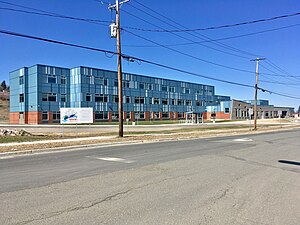
Le Galion des Appalaches is a Francophone K-8 school in Campbellton, New Brunswick. It was recently built and opened in January 2018. When it opened, it combined all students from Apollo XI, in Campbellton, Versant-Nord in Atholville, Mgr Melanson in Val-d'Amours, and Rendez-vous des Jeunes in Saint-Arthur, as well as the 7th and 8th graders from the Polyvalente Roland-Pépin, just up the street.
Weather in this IP's area
overcast clouds
-0 Celsius
-0 Celsius
-0 Celsius
-0 Celsius
1021 hPa
87 %
1021 hPa
1009 hPa
10000 meters
0.71 m/s
2.13 m/s
260 degree
100 %