Country:
Region:
City:
Latitude and Longitude:
Time Zone:
Postal Code:
IP information under different IP Channel
ip-api
Country
Region
City
ASN
Time Zone
ISP
Blacklist
Proxy
Latitude
Longitude
Postal
Route
Luminati
Country
Region
la
City
covington
ASN
Time Zone
America/Chicago
ISP
FOGODC
Latitude
Longitude
Postal
IPinfo
Country
Region
City
ASN
Time Zone
ISP
Blacklist
Proxy
Latitude
Longitude
Postal
Route
db-ip
Country
Region
City
ASN
Time Zone
ISP
Blacklist
Proxy
Latitude
Longitude
Postal
Route
ipdata
Country
Region
City
ASN
Time Zone
ISP
Blacklist
Proxy
Latitude
Longitude
Postal
Route
Popular places and events near this IP address

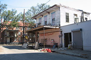
Storyville, New Orleans
Former red-light district in Louisiana, US
Distance: Approx. 480 meters
Latitude and longitude: 29.95908056,-90.07381389
Storyville was the red-light district of New Orleans, Louisiana, from 1897 to 1917. It was established by municipal ordinance under the New Orleans City Council, to regulate prostitution. Sidney Story, a city alderman, wrote guidelines and legislation to control prostitution within the city.

13th Ward of New Orleans
Distance: Approx. 488 meters
Latitude and longitude: 29.964722,-90.070556
The 13th Ward or Thirteenth Ward is a division of the city of New Orleans, Louisiana. It is one of the 17 Wards of New Orleans. The Ward was formerly part of the old Jefferson City annexed by New Orleans in 1870.

Rampart Street
Street in New Orleans, USA
Distance: Approx. 584 meters
Latitude and longitude: 29.9683,-90.0739
Rampart Street (French: rue du Rempart) is a historic avenue located in New Orleans, Louisiana. The section of Rampart Street downriver from Canal Street is designated as North Rampart Street, which forms the inland or northern border of the French Quarter (Vieux Carre). Crossing Esplanade Avenue, the street continues into the Faubourg Marigny neighborhood, then splits off from St.

Iberville Projects
New Orleans Neighborhood in Louisiana, United States
Distance: Approx. 449 meters
Latitude and longitude: 29.95944444,-90.07361111
Iberville Projects was a neighborhood in the city of New Orleans and one of the low-income Housing Projects of New Orleans. The Iberville was the last of the New Deal-era public housing remaining in the city. Its boundaries were St.
Mahalia Jackson Theater of the Performing Arts
Distance: Approx. 578 meters
Latitude and longitude: 29.96312,-90.06931
The Mahalia Jackson Theater of the Performing Arts is a theater located in Louis Armstrong Park in New Orleans, Louisiana. It was named after gospel singer Mahalia Jackson, who was born in New Orleans. The theater reopened in January 2009, after being closed since the landfall of Hurricane Katrina (August 29, 2005).

Backstreet Cultural Museum
Museum in New Orleans, Louisiana
Distance: Approx. 585 meters
Latitude and longitude: 29.965971,-90.070145
The Backstreet Cultural Museum is a museum in New Orleans, Louisiana's Tremé neighborhood, founded by Sylvester Francis.
Grand Palace Hotel, New Orleans
Distance: Approx. 551 meters
Latitude and longitude: 29.9591,-90.0785
The Grand Palace Hotel was a 17-story building located in the Mid City area of New Orleans, Louisiana. The building became known worldwide for its implosion on 22 July 2012.
St. James AME Church (New Orleans, Louisiana)
Historic church in Louisiana, United States
Distance: Approx. 414 meters
Latitude and longitude: 29.96083333,-90.07861111
Historic St. James AME Church is a historic church, affiliated with the African Methodist Episcopal Church, the oldest predominantly African American denomination in the United States. The church is located at 222 N. Roman Street in New Orleans, Louisiana.

Southern Railway Freight Office (New Orleans, Louisiana)
Distance: Approx. 579 meters
Latitude and longitude: 29.95972222,-90.07083333
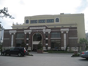
The Southern Railway Freight Office now more commonly known as Basin Street Station, in New Orleans, Louisiana, was constructed in 1904 by the Southern Railway at the corner of Basin Street and Saint Louis Street. The site was located just outside the original city in an area that was considered useless swampy land. The station was also used by the New Orleans Terminal Company.

1891 New Orleans lynchings
Murder of eleven Italian men by a mob
Distance: Approx. 458 meters
Latitude and longitude: 29.96305556,-90.07055556
The 1891 New Orleans lynchings were the murders of 11 Italian Americans, immigrants in New Orleans, by a mob for their alleged role in the murder of police chief David Hennessy after some of them had been acquitted at trial. It was the largest single mass lynching in American history. Most of the lynching victims accused in the murder had been rounded up and charged due to their Italian ethnicity.

Carver Theater (New Orleans)
Theater in New Orleans, Louisiana, US
Distance: Approx. 451 meters
Latitude and longitude: 29.96708,-90.07665
The Carver Theatre is a theater located in New Orleans, Louisiana. The theatre was originally built in 1950 and was used for concerts, plays, off-broadway shows, films, conventions, graduations, Mardi Gras balls, dance recitals, corporate events and private parties.
Coliseum Arena
Former arena in New Orleans, Louisiana
Distance: Approx. 205 meters
Latitude and longitude: 29.96284,-90.07738
The Coliseum Arena or Coliseum Auditorium was an arena at 401 North Roman Street in the Tulane/Gravier neighborhood of New Orleans. It was located at the corner of N. Roman St. and Conti St.
Weather in this IP's area
scattered clouds
24 Celsius
25 Celsius
23 Celsius
25 Celsius
1013 hPa
85 %
1013 hPa
1013 hPa
10000 meters
2.24 m/s
4.92 m/s
139 degree
31 %
06:18:26
17:09:29

