Country:
Region:
City:
Latitude and Longitude:
Time Zone:
Postal Code:
IP information under different IP Channel
ip-api
Country
Region
City
ASN
Time Zone
ISP
Blacklist
Proxy
Latitude
Longitude
Postal
Route
Luminati
Country
Region
ga
City
carrollton
ASN
Time Zone
America/New_York
ISP
FOGODC
Latitude
Longitude
Postal
IPinfo
Country
Region
City
ASN
Time Zone
ISP
Blacklist
Proxy
Latitude
Longitude
Postal
Route
db-ip
Country
Region
City
ASN
Time Zone
ISP
Blacklist
Proxy
Latitude
Longitude
Postal
Route
ipdata
Country
Region
City
ASN
Time Zone
ISP
Blacklist
Proxy
Latitude
Longitude
Postal
Route
Popular places and events near this IP address

Carroll County, Georgia
County in Georgia, United States
Distance: Approx. 169 meters
Latitude and longitude: 33.58,-85.08
Carroll County is a county in the West Central region of the State of Georgia. As of the 2020 census, its population was 119,148. Its county seat is the city of Carrollton.
Carrollton, Georgia
City in Georgia, United States
Distance: Approx. 345 meters
Latitude and longitude: 33.58083333,-85.07666667
Carrollton is a city in and the county seat of Carroll County, Georgia, United States. It is within western Georgia, about 45 miles (72 km) west of Atlanta near the Alabama state line, and is included in the Atlanta metropolitan area. It is the home of the University of West Georgia and West Georgia Technical College.
WUWG
Radio station at the University of West Georgia
Distance: Approx. 6122 meters
Latitude and longitude: 33.564,-85.01772222
WUWG, FM 90.7, is the radio station that formerly broadcast at the University of West Georgia in Carrollton, Georgia, and is now a part of the Georgia Public Broadcasting radio state network. This station is one of several in the GPB system that also produces its own programming; however, the vast majority of the broadcast day is a simulcast of the statewide feed. That feed is also duplicated locally both by GPB's WJSP-FM in Warm Springs and WGPB-FM in Rome, with most NPR programming also carried by non-GPB station WABE from nearby Atlanta.

Carrollton High School (Carrollton, Georgia)
Public high school in Carrollton, Georgia, United States
Distance: Approx. 1692 meters
Latitude and longitude: 33.5663125,-85.0810625
Carrollton High School is a public high school in Carrollton, Georgia, United States, part of the Carrollton City School System. The school's mascot is the Trojan.

Grisham Stadium
Distance: Approx. 1923 meters
Latitude and longitude: 33.564262,-85.081723
Grisham Stadium, Maddox - Musselwhite Track at Historic Trojan Field is a multi-purpose stadium in Carrollton, Georgia, United States. The stadium is home to the many athletic teams at Carrollton High School and hosts various additional functions for the Carrollton City School District.

University Stadium (West Georgia)
Distance: Approx. 4022 meters
Latitude and longitude: 33.579767,-85.123615
University Stadium is an on-campus stadium in Carrollton, Georgia that opened in 2009. It is primarily used for American football and is the home field of the University of West Georgia Wolves. The stadium holds 10,000 people.
Carroll County School District (Georgia)
School district in Georgia, United States
Distance: Approx. 3625 meters
Latitude and longitude: 33.569802,-85.04382
The Carroll County School System is a public school district in Carroll County, Georgia, United States, based in Carrollton. It includes portions of Carroll County not within the city limits of Carrollton, nor those of Bremen. It serves the communities of Bowdon, two thirds of unincorporated Bremen, Mount Zion, Roopville, Temple, Villa Rica, and Whitesburg.
Carrollton City School District
School district in Georgia (U.S. state)
Distance: Approx. 1624 meters
Latitude and longitude: 33.5669375,-85.0793125
The Carrollton City School District is a public school district in Carroll County, Georgia, United States, based in and serving the city of Carrollton.
Central High School (Carrollton, Georgia)
Public high school in Carrollton, Georgia, United States
Distance: Approx. 3393 meters
Latitude and longitude: 33.5525,-85.06902778
Central High School is a public high school, part of the Carroll County School System, located just outside Carrollton, Georgia, United States.
George Washington Carver High School (Carrollton, Georgia)
Public black school in Carrollton, Georgia, United States
Distance: Approx. 192 meters
Latitude and longitude: 33.582938,-85.081437
George Washington Carver High School was a public secondary school in Carrollton, Georgia, United States. It served as the only high school for African American students in Carroll County during segregation. The school closed in 1969 with the completion of the county's integration process.

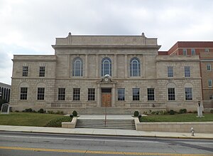
Carroll County Courthouse (Georgia)
United States historic place
Distance: Approx. 734 meters
Latitude and longitude: 33.57944444,-85.07277778
The Carroll County Courthouse in Carrollton, Georgia was built in 1928. It was listed on the National Register of Historic Places in 1980. It is located at Newnan and Dixie Streets in Carrollton.
The Coliseum (West Georgia)
Multi-purpose arena in Carrollton, Georgia
Distance: Approx. 2270 meters
Latitude and longitude: 33.5761,-85.1039
The Coliseum is a multi-purpose arena in Carrollton, Georgia, USA. It is home to the University of West Georgia Wolves men's and women's basketball and volleyball teams. In addition to hosting Wolves basketball and volleyball, the arena has gained a reputation as a concert venue, hosting acts such as Ludacris, Cole Swindell and Florida Georgia Line.
Weather in this IP's area
overcast clouds
19 Celsius
19 Celsius
18 Celsius
20 Celsius
1018 hPa
97 %
1018 hPa
979 hPa
10000 meters
3.09 m/s
130 degree
100 %
07:04:11
17:43:47
