Country:
 Singapore
Region:
City:
Latitude and Longitude:
Time Zone:
Postal Code:
IP information under different IP Channel
ip-api
Country
Region
City
ASN
Time Zone
ISP
Blacklist
Proxy
Latitude
Longitude
Postal
Route
IPinfo
Country
Region
City
ASN
Time Zone
ISP
Blacklist
Proxy
Latitude
Longitude
Postal
Route
MaxMind
Country
Region
City
ASN
Time Zone
ISP
Blacklist
Proxy
Latitude
Longitude
Postal
Route
Luminati
Country
 HK
HKASN
Time Zone
Asia/Hong_Kong
ISP
China Unicom Global
Latitude
Longitude
Postal
db-ip
Country
Region
City
ASN
Time Zone
ISP
Blacklist
Proxy
Latitude
Longitude
Postal
Route
ipdata
Country
Region
City
ASN
Time Zone
ISP
Blacklist
Proxy
Latitude
Longitude
Postal
Route
Popular places and events near this IP address
Ngee Ann Polytechnic
Post-secondary academic institution in Singapore
Distance: Approx. 1049 meters
Latitude and longitude: 1.33361111,103.77694444
Ngee Ann Polytechnic (NP) is a post-secondary education institution and statutory board under the purview of the Ministry of Education in Singapore. Established in 1963 by the Ngee Ann Kongsi, NP is renowned for its business programmes and central focus on entrepreneurship education. It is also the only polytechnic in Singapore to be affiliated with a foundation.
Singapore University of Social Sciences
University in Singapore
Distance: Approx. 1247 meters
Latitude and longitude: 1.32916667,103.77638889
The Singapore University of Social Sciences (SUSS) is a public autonomous university in Singapore. Established in 2017, SUSS focuses on applied degree programmes primarily in the social sciences. In 2017, SUSS received its inaugural class of 2,137 graduates.
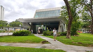
Beauty World MRT station
Mass Rapid Transit station in Singapore
Distance: Approx. 1004 meters
Latitude and longitude: 1.341133,103.775797
Beauty World MRT station is an underground Mass Rapid Transit (MRT) station on the Downtown Line (DTL) in Bukit Timah, Singapore. Located along Upper Bukit Timah Road, this station took its name from the historic Beauty World Market, a former amusement park and market that once stood in the vicinity. Beauty World station primarily serves the residential estates along Jalan Jurong Kechil and Toh Yi Drive, as well as Beauty World Centre, Beauty World Plaza, and Bukit Timah Shopping Centre.
Bukit Batok Bus Depot
Distance: Approx. 1558 meters
Latitude and longitude: 1.3403,103.7545
Bukit Batok Bus Depot is a bus depot located at 550 Bukit Batok Street 23, Singapore 659519. It is over 50,000 square metres, with bus washing facilities, a canteen, and fuel stations.

Bukit Timah railway station
Train station in Bukit Timah, Singapore
Distance: Approx. 1484 meters
Latitude and longitude: 1.33416667,103.78111111
Bukit Timah railway station was a former railway station and crossing loop in Bukit Timah, Singapore. Opened on the dismantled Tank Road mainline in 1903, it was rebuilt on the current Singapore–Johor Bahru KTM Intercity mainline in 1932, until the Jurong Line shut down and it became a crossing loop station in the late 1940s until closure. The station was a freight interchange for the now defunct Jurong Line from 1965 to the early 1990s.

Church of St Mary of the Angels
Distance: Approx. 1492 meters
Latitude and longitude: 1.347141,103.759735
The Church of St. Mary of the Angels is a Roman Catholic church in Singapore completed in 2004. It is located in the Bukit Batok Planning Area, within the West Region of Singapore.
Beauty World Market
Former market in Bukit Timah, Singapore
Distance: Approx. 957 meters
Latitude and longitude: 1.34166667,103.77494444
Beauty World Market was an open-air market that was opened in July 1947 in Singapore. It was located at the junction of Upper Bukit Timah Road and Jalan Jurong Kechil. Just next to it was Beauty World Town, another shopping place was opened in 1962.
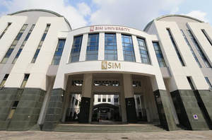
SIM University
Private university in Singapore (2005–2017)
Distance: Approx. 1247 meters
Latitude and longitude: 1.32916667,103.77638889
SIM University (UniSIM) was a private university in Singapore that opened in 2005 before shutting down in 2017. The university was established and managed under the Singapore Institute of Management (SIM) Group. It was the only private university in Singapore after Nanyang University.
SUSS School of Law
Distance: Approx. 1247 meters
Latitude and longitude: 1.32916667,103.77638889
The Singapore University of Social Sciences School of Law (SUSS School of Law) is an autonomous law school of Singapore University of Social Sciences. It was established in 2017, as Singapore's third law school after the NUS Faculty of Law and the SMU School of Law. The school was established to address the shortage of practitioners in family and criminal law.

Bukit Timah Truss Bridge
Distance: Approx. 1453 meters
Latitude and longitude: 1.3368,103.78105
The Bukit Timah Truss Bridge is a former railway bridge going over Bukit Timah Road and Dunearn Road in Bukit Timah, Singapore.
Maju MRT station
Future Mass Rapid Transit station in Singapore
Distance: Approx. 1349 meters
Latitude and longitude: 1.328462,103.776993
Maju MRT station is a future underground Mass Rapid Transit station on the Cross Island line (CRL) located in Bukit Timah, Singapore. First announced in September 2022, the station is expected to be completed in 2032 along with the other CRL Phase 2 stations.

Former Bukit Timah Fire Station
Building in Singapore, Singapore
Distance: Approx. 1425 meters
Latitude and longitude: 1.3491,103.7707
The Former Bukit Timah Fire Station (BTFS) (also known as the Old Bukit Timah Fire Station and the Bukit Timah Fire Station), located in Upper Bukit Timah Road, Singapore, was a fire station. It is planned to be redesigned into a community centre for nature. It is nearby the upcoming Hume MRT station.
Weather in this IP's area
broken clouds
29 Celsius
33 Celsius
28 Celsius
31 Celsius
1008 hPa
74 %
1008 hPa
1003 hPa
10000 meters
1.54 m/s
320 degree
75 %
06:58:56
19:06:40