Country:
 Curacao
Region:
City:
Latitude and Longitude:
Time Zone:
Postal Code:
IP information under different IP Channel
ip-api
Country
Region
City
ASN
Time Zone
ISP
Blacklist
Proxy
Latitude
Longitude
Postal
Route
IPinfo
Country
Region
City
ASN
Time Zone
ISP
Blacklist
Proxy
Latitude
Longitude
Postal
Route
MaxMind
Country
Region
City
ASN
Time Zone
ISP
Blacklist
Proxy
Latitude
Longitude
Postal
Route
Luminati
Country
 US
USASN
Time Zone
America/Chicago
ISP
CL-1379-14537
Latitude
Longitude
Postal
db-ip
Country
Region
City
ASN
Time Zone
ISP
Blacklist
Proxy
Latitude
Longitude
Postal
Route
ipdata
Country
Region
City
ASN
Time Zone
ISP
Blacklist
Proxy
Latitude
Longitude
Postal
Route
Popular places and events near this IP address

Sint Anna Bay
Distance: Approx. 646 meters
Latitude and longitude: 12.1097,-68.9326
Sint Anna Bay (Dutch: Sint Annabaai) is a deep channel approximately one mile long and up to 1,000 feet wide, located on the island of Curaçao between the two parts of Willemstad, Punda and Otrobanda. The bay opens into the Caribbean Sea at the southern end, and into the Schottegat lagoon/industrial area to the north.

Central Bank of Curaçao and Sint Maarten
Distance: Approx. 631 meters
Latitude and longitude: 12.108,-68.9284
The Central Bank of Curaçao and Sint Maarten (CBCS; Papiamento: Banko Sentral di Kòrsou i Sint Maarten, Dutch: Centrale Bank van Curaçao en Sint Maarten; previously the Bank of the Netherlands Antilles) is the central bank for the Netherlands Antillean guilder and administers the monetary policy of Curaçao and Sint Maarten. The bank dates to 1828 making it the oldest surviving central bank in the Americas. Prior to the dissolution of the Netherlands Antilles in October 2010, the bank was responsible for monetary policy throughout the Netherlands Antilles.
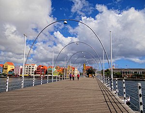
Queen Emma Bridge
Bridge in Willemstad, Curaçao
Distance: Approx. 398 meters
Latitude and longitude: 12.10611111,-68.93527778
The Queen Emma Bridge (Dutch: Koningin Emmabrug; Papiamento: Brùg di Ponton, Brùg di Punda) is a pontoon bridge across St. Anna Bay on Curaçao island in the Dutch Caribbean. It connects the Punda and Otrobanda quarters of the capital city, Willemstad.

Curaçao Synagogue
Synagogue in Willemstad, Curaçao
Distance: Approx. 123 meters
Latitude and longitude: 12.105,-68.9325
The Mikvé Israel-Emanuel Synagogue (Hebrew: בית הכנסת מקווה ישראל-עמנואל, lit. 'Hope of Israel-Emanuel Synagogue'), is a Reconstructionist Jewish congregation and synagogue, located at Hanchi di Snoa 29, Punda, in the city of Willemstad, Curaçao, a constituent country of the Kingdom of the Netherlands in southern Caribbean Sea. The congregation was established in 1651 and the synagogue was completed in 1732, making it the oldest surviving synagogue in the Americas. Commonly known as the Snoa (short for esnoga, an old Portuguese and Judaeo-Spanish word for synagogue), it is a major tourist attraction in Curaçao, and was visited by Queen Beatrix of the Netherlands and her family in 1992.
Avalon University School of Medicine
Medical school in Willemstad, Curacao
Distance: Approx. 663 meters
Latitude and longitude: 12.107,-68.9272
Avalon University School of Medicine (AUSOM) (previously Xavier University School of Medicine in Bonaire) is a private medical school located in Willemstad, Curaçao, in the Caribbean. AUSOM confers upon its graduates the Doctor of Medicine (MD) degree. Administrative offices for the university are located in Youngstown, Ohio.
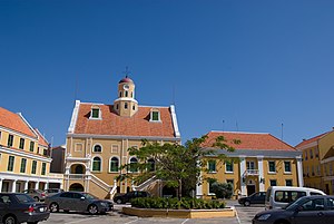
Fort Amsterdam (Curaçao)
Building in Willemstad, Curaçao
Distance: Approx. 245 meters
Latitude and longitude: 12.1047,-68.9345
Fort Amsterdam is a fort located in Willemstad, Curaçao. It was constructed in 1634 by the Dutch West India Company (WIC) and served not only as a military fort but also as the headquarters of the WIC. Currently it serves as the seat of the government and governor of Curaçao. The fort is named after the Amsterdam chamber of the WIC and was considered the main of eight forts on the island.

Basilica of St. Anne, Willemstad
Church in Curaçao, Netherlands
Distance: Approx. 667 meters
Latitude and longitude: 12.10833333,-68.93652778
The Basilica of St. Anne (Papiamento: Basilika Santa Ana; Dutch: Basiliek Santa Ana) It is a religious building that functions as Catholic Minor Basilica and at the same time as co-cathedral of the Diocese of Willemstad (Latin: Dioecesis Gulielmopolitana) on the island of Curaçao in the Caribbean Sea off the coast of Venezuela. The other being the main cathedral dedicated to Our Lady the Queen of the Holy Rosary of the same city.

Pietermaai
Neighbourhood in Willemstad, Curaçao, Kingdom of the Netherlands
Distance: Approx. 616 meters
Latitude and longitude: 12.103,-68.92682
Pietermaai is a neighbourhood and former suburb of Willemstad, on Curaçao, a Lesser Antilles island in the Dutch Caribbean. Pietermaai was founded in 1675, and has been designated a Unesco World Heritage Site.

Kurá Hulanda Museum
Museums of Curaçao
Distance: Approx. 576 meters
Latitude and longitude: 12.10801,-68.93562
Kurá Hulanda Museum is an anthropological museum in Curaçao. The museum specialises in the Atlantic slave trade, and opened in April 1999.

Plaza Hotel Curaçao
Hotel in Curaçao
Distance: Approx. 283 meters
Latitude and longitude: 12.10388889,-68.935
Plaza Hotel Curaçao is a former hotel in Willemstad, Curaçao. It was constructed in the Waterfort, and opened on 12 October 1957 as Hotel Curaçao Intercontinental. It is the tallest building on the island.

Waterfort
Building in Willemstad, Curaçao
Distance: Approx. 303 meters
Latitude and longitude: 12.1038,-68.93518
Waterfort is a fort in Willemstad, Curaçao located on the eastern side of the Sint Anna Bay. It was built in 1827 to protect Willemstad against attack. In 1858, marines were stationed in the fort.
Fort Church, Curaçao
Church in Curaçao, Netherlands
Distance: Approx. 231 meters
Latitude and longitude: 12.10446111,-68.93443889
The Fort Church (Dutch: Fortkerk) is a church of the United Protestant Community located in the court of Fort Amsterdam in Willemstad, Curaçao. The church dates from 1796, and is still in use. A museum is located in the basement.
Weather in this IP's area
few clouds
31 Celsius
38 Celsius
31 Celsius
31 Celsius
1008 hPa
74 %
1008 hPa
1007 hPa
10000 meters
2.57 m/s
60 degree
20 %
06:24:48
18:21:45