Country:
 USA
USARegion:
City:
Latitude and Longitude:
Time Zone:
Postal Code:
IP information under different IP Channel
ip-api
Country
Region
City
ASN
Time Zone
ISP
Blacklist
Proxy
Latitude
Longitude
Postal
Route
IPinfo
Country
Region
City
ASN
Time Zone
ISP
Blacklist
Proxy
Latitude
Longitude
Postal
Route
MaxMind
Country
Region
City
ASN
Time Zone
ISP
Blacklist
Proxy
Latitude
Longitude
Postal
Route
Luminati
Country
USASN
Time Zone
America/Chicago
ISP
AMAZON-AS
Latitude
Longitude
Postal
db-ip
Country
Region
City
ASN
Time Zone
ISP
Blacklist
Proxy
Latitude
Longitude
Postal
Route
ipdata
Country
Region
City
ASN
Time Zone
ISP
Blacklist
Proxy
Latitude
Longitude
Postal
Route
Popular places and events near this IP address

Bryn Mawr-Skyway, Washington
Census-designated place in Washington, United States
Distance: Approx. 1603 meters
Latitude and longitude: 47.49444444,-122.23666667
Bryn Mawr-Skyway (pronounced from Welsh for "big hill") is a census-designated place (CDP) in King County, Washington, United States. The population was 17,397 at the 2020 census. Bryn Mawr-Skyway was the only CDP in the Seattle metropolitan area to have reported a majority-minority population in the 2000 census.

Tukwila, Washington
City in Washington, United States
Distance: Approx. 2251 meters
Latitude and longitude: 47.47833333,-122.27555556
Tukwila ( tuk-WIL-ə) is a suburban city in King County, Washington, United States, located immediately to the south of Seattle. The population was 21,798 at the 2020 census. A large commercial center draws workers and consumers to the city daily; industry thrives with the confluence of rivers, freeways, railroads, and Seattle–Tacoma International Airport.

Green River (Duwamish River tributary)
Tributary of the Duwamish River in Washington, United States
Distance: Approx. 1678 meters
Latitude and longitude: 47.46666667,-122.25
The Green River is a 65-mile (105 km) long river in the state of Washington in the United States, arising on the western slopes of the Cascade Range south of Interstate 90. The upper Green River valley forms the western approach to Stampede Pass, and was once home to many small railroad and logging towns such as Weston, Lester, Green River Hot Springs, Nagrom, Maywood, Humphreys, Eagle Gorge, Lemolo, and Kanaskat. Shortly before World War I, the City of Tacoma, Washington, filed for water rights on the Green River.
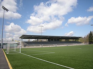
Starfire Sports
Stadium and sports facility in Tukwila, Washington, U.S.
Distance: Approx. 1323 meters
Latitude and longitude: 47.46972222,-122.24833333
Starfire Sports is a multi-purpose stadium and sporting facility in Tukwila, Washington, United States. It is located on the banks of the Green River, just south of Seattle. The stadium is operated by the nonprofit corporation Starfire Sports and is home to several soccer and rugby teams.

Interurban Trail (King County)
Rail trail in Washington, United States
Distance: Approx. 1994 meters
Latitude and longitude: 47.46361111,-122.24472222
The Interurban Trail are a pair of trails in Washington. The interurban Trail North is a bicycle route running from Downtown Seattle through Shoreline and to the Snohomish County, Washington line. The Interurban Trail South is a rail trail in King and Pierce counties.

Fort Dent
Distance: Approx. 1655 meters
Latitude and longitude: 47.46669444,-122.24805556
Fort Dent is a historic fort and present-day park in Tukwila, Washington.
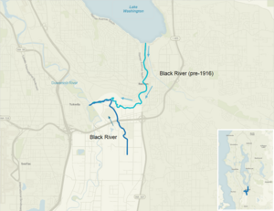
Black River (Duwamish River tributary)
Distance: Approx. 894 meters
Latitude and longitude: 47.47416667,-122.25083333
The Black River is a tributary of the Duwamish River in King County in the U.S. state of Washington. It drained Lake Washington until 1916, when the opening of the Lake Washington Ship Canal lowered the lake, causing part of the Black River to dry up. It still exists as a dammed stream about 2 miles (3.2 km) long.

Tukwila station
Amtrak and commuter train station in Tukwila, Washington
Distance: Approx. 2367 meters
Latitude and longitude: 47.46055556,-122.24055556
Tukwila station is a train station in Tukwila, Washington, United States. The station was built by Sound Transit to serve its Sounder commuter rail service on the S Line, as well as Amtrak's intercity Cascades line. It includes 390 parking spaces and a bus platform served by King County Metro's RapidRide F Line and other routes.
Johnson Braund Design Group
Distance: Approx. 2360 meters
Latitude and longitude: 47.46697,-122.268839
Johnson Braund, Inc. is an architecture and design firm with based out of Seattle, Washington. Firm acts as prototype designer for a number of Marriott International chains, including Residence Inn by Marriott, Courtyard by Marriott, and SpringHill Suites.

Foster, Washington
Ghost town in Washington (state)
Distance: Approx. 2224 meters
Latitude and longitude: 47.48138889,-122.27555556
Foster, Washington was a former community in King County in the U.S. state of Washington. After being annexed in 1989, Foster's former area is a part of the city of Tukwila. A post office called Foster was established in 1903, and remained in operation until 1907.
Renton School District
Public school district headquartered in Renton, Washington, USA
Distance: Approx. 2081 meters
Latitude and longitude: 47.47416667,-122.22055556
Renton School District 403 is a public school district headquartered in Renton, Washington, USA. The district boundaries include the vast majority of Renton, all of Bryn Mawr-Skyway, and portions of the adjacent cities and communities of Bellevue, East Renton Highlands, Fairwood, Kent, Newcastle, SeaTac, and Tukwila. On October 1 of the 2017-2018 school year, the district has an enrollment of 16,336 students.

Tukwila School
Historic building in Washington, USA
Distance: Approx. 1321 meters
Latitude and longitude: 47.47222222,-122.25694444
The Tukwila School, later known as Tukwila Town Hall and Tukwila Library, is a public building in Tukwila, Washington. Built in 1920, the former school was added to the National Register of Historic Places in 1979.
Weather in this IP's area
scattered clouds
20 Celsius
20 Celsius
19 Celsius
22 Celsius
1014 hPa
62 %
1014 hPa
1004 hPa
10000 meters
3.6 m/s
270 degree
40 %
06:52:31
19:12:41