Country:
 USA
USARegion:
City:
Latitude and Longitude:
Time Zone:
Postal Code:
IP information under different IP Channel
ip-api
Country
Region
City
ASN
Time Zone
ISP
Blacklist
Proxy
Latitude
Longitude
Postal
Route
IPinfo
Country
Region
City
ASN
Time Zone
ISP
Blacklist
Proxy
Latitude
Longitude
Postal
Route
MaxMind
Country
Region
City
ASN
Time Zone
ISP
Blacklist
Proxy
Latitude
Longitude
Postal
Route
Luminati
Country
USRegion
il
City
pawpaw
ASN
Time Zone
America/Chicago
ISP
SN-2006
Latitude
Longitude
Postal
db-ip
Country
Region
City
ASN
Time Zone
ISP
Blacklist
Proxy
Latitude
Longitude
Postal
Route
ipdata
Country
Region
City
ASN
Time Zone
ISP
Blacklist
Proxy
Latitude
Longitude
Postal
Route
Popular places and events near this IP address

Paw Paw, Illinois
Village in Illinois, United States
Distance: Approx. 1267 meters
Latitude and longitude: 41.68777778,-88.9825
Paw Paw is a village in Lee County in the U.S. state of Illinois. As of the 2020 census, the village was home to 830 people, down from 870 at the 2010 census. It was settled in the mid 19th century and by 1878 the village had a railroad connection.

Nisbet Homestead Farm
United States historic place
Distance: Approx. 8966 meters
Latitude and longitude: 41.67111111,-88.86277778
Nisbet Homestead Farm, also known as the Old Stone House, is located near the LaSalle County town of Earlville, Illinois. The farm itself is actually in DeKalb County. The homestead is a stone structure, the only one in DeKalb County.

Willow Creek Township, Lee County, Illinois
Township in Illinois, United States
Distance: Approx. 8841 meters
Latitude and longitude: 41.75888889,-88.99416667
Willow Creek Township is located in Lee County, Illinois. As of the 2010 census, its population was 688 and it contained 277 housing units. Willow Creek Township was formed from Wyoming Township in September, 1854.

Wyoming Township, Lee County, Illinois
Township in Illinois, United States
Distance: Approx. 1796 meters
Latitude and longitude: 41.67944444,-88.99111111
Wyoming Township is located in Lee County, Illinois. As of the 2010 census, its population was 1,376 and it contained 589 housing units. Wyoming Township was originally named Paw Paw Township, but the name was changed on May 14, 1850.

Paw Paw Township, DeKalb County, Illinois
Township in Illinois, United States
Distance: Approx. 7304 meters
Latitude and longitude: 41.67555556,-88.88222222
Paw Paw Township is one of nineteen townships in DeKalb County, Illinois, USA. As of the 2020 census, its population was 345 and it contained 130 housing units.

Stephen Wright House
Historic house in Illinois, United States
Distance: Approx. 1695 meters
Latitude and longitude: 41.68972222,-88.98694444
The Stephen Wright House is a home located in the Lee County, Illinois, United States, village of Paw Paw. The Queen Anne style home was constructed sometime between 1895 and 1906 by Paw Paw real estate speculator Stephen Wright. Located along a former Native American trail and stagecoach line, the home is in an area of very similar Queen Anne style homes which may have also been built by Wright.
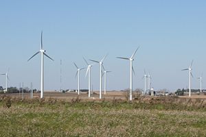
Mendota Hills Wind Farm
Distance: Approx. 7986 meters
Latitude and longitude: 41.7256,-89.0456
The Mendota Hills Wind Farm is a wind farm in Lee County, Illinois near the village of Paw Paw. It operates 29 wind turbines. Each wind turbine stands 214 ft (65.23 m) tall and has three 85 ft (35.91 m) long blades.
Paw Paw High School (Illinois)
Comprehensive public high school in Paw Paw, Lee County, Illinois, United States
Distance: Approx. 1180 meters
Latitude and longitude: 41.6903,-88.9778
Paw Paw High School, or PPHS, was a public high school in Paw Paw, Illinois from 1841 until 2019. The campus was located 20 miles south of Rochelle, Illinois, and served a mixed village and rural residential community.
East Paw Paw, Illinois
Unincorporated community in Illinois, United States
Distance: Approx. 2638 meters
Latitude and longitude: 41.68805556,-88.93916667
East Paw Paw is an unincorporated community in DeKalb and Lee counties, Illinois, United States, located 2 miles (3.2 km) east of Paw Paw.
Rollo, Illinois
Unincorporated community in Illinois, United States
Distance: Approx. 7015 meters
Latitude and longitude: 41.67305556,-88.88611111
Rollo is an unincorporated community in DeKalb County, Illinois, United States, located 5 miles (8.0 km) east-southeast of Paw Paw.

Roxbury, Illinois
Unincorporated community in Illinois, United States
Distance: Approx. 6170 meters
Latitude and longitude: 41.70055556,-89.03944444
Roxbury is an unincorporated community in Lee County, Illinois, United States. Roxbury is located on County Route 10, 3.1 miles (5.0 km) west-northwest of Paw Paw.
Rollo Congregational United Church of Christ
Historic church in Illinois, United States
Distance: Approx. 6937 meters
Latitude and longitude: 41.67222222,-88.88722222
Rollo Congregational United Church of Christ is a Congregational church at 2471 Weddell Street in Rollo, Illinois. Rollo's Congregational church was founded in 1865; it originally met in a wooden church in rural Paw Paw Township and moved to Rollo in 1886. The present church building was built in 1913 after a storm damaged the previous church.
Weather in this IP's area
clear sky
19 Celsius
18 Celsius
19 Celsius
21 Celsius
1017 hPa
29 %
1017 hPa
986 hPa
10000 meters
4.24 m/s
5.46 m/s
279 degree
1 %
07:00:37
18:25:37