162.220.107.21 - IP Lookup: Free IP Address Lookup, Postal Code Lookup, IP Location Lookup, IP ASN, Public IP
Country:
Region:
City:
Location:
Time Zone:
Postal Code:
IP information under different IP Channel
ip-api
Country
Region
City
ASN
Time Zone
ISP
Blacklist
Proxy
Latitude
Longitude
Postal
Route
Luminati
Country
Region
pa
City
breinigsville
ASN
Time Zone
America/New_York
ISP
AS17378
Latitude
Longitude
Postal
IPinfo
Country
Region
City
ASN
Time Zone
ISP
Blacklist
Proxy
Latitude
Longitude
Postal
Route
IP2Location
162.220.107.21Country
Region
pennsylvania
City
breinigsville
Time Zone
America/New_York
ISP
Language
User-Agent
Latitude
Longitude
Postal
db-ip
Country
Region
City
ASN
Time Zone
ISP
Blacklist
Proxy
Latitude
Longitude
Postal
Route
ipdata
Country
Region
City
ASN
Time Zone
ISP
Blacklist
Proxy
Latitude
Longitude
Postal
Route
Popular places and events near this IP address

Longswamp Township, Pennsylvania
Township in Pennsylvania, United States
Distance: Approx. 4053 meters
Latitude and longitude: 40.50083333,-75.62388889
Longswamp Township is a township in Berks County, Pennsylvania, United States. The population was 5,551 at the 2020 census.
Alburtis, Pennsylvania
Borough in Pennsylvania, United States
Distance: Approx. 3882 meters
Latitude and longitude: 40.51,-75.60194444
Alburtis is a borough in Lehigh County, Pennsylvania, United States. The borough's population was 2,596 as of the 2020 census. It is a suburb of Allentown, the third largest city in Pennsylvania.
Ancient Oaks, Pennsylvania
Census-designated place in Pennsylvania, United States
Distance: Approx. 3496 meters
Latitude and longitude: 40.53583333,-75.59
Ancient Oaks is a census-designated place (CDP) in Lower Macungie Township in Lehigh County, Pennsylvania, United States. It is named after the housing subdivision named Ancient Oaks, located off PA Route 100 just north of Macungie. The population of Ancient Oaks was 6,995 at the 2020 census.
Breinigsville, Pennsylvania
Census-designated place in Pennsylvania, United States
Distance: Approx. 17 meters
Latitude and longitude: 40.53666667,-75.63138889
Breinigsville is an unincorporated community and census-designated place (CDP) in Lehigh County, Pennsylvania. As of the 2020 census, it had a population of 7,495. The town is part of Upper Macungie Township and is located approximately 11 miles (18 km) southwest of downtown Allentown and 8 miles (13 km) east of Kutztown.

Trexlertown, Pennsylvania
Census-designated place in Pennsylvania, United States
Distance: Approx. 2492 meters
Latitude and longitude: 40.54805556,-75.60583333
Trexlertown is an unincorporated community and census-designated place (CDP) in Upper Macungie Township in Lehigh County, Pennsylvania. As of the 2020 census, the population was 2,382. It is part of the Lehigh Valley, which had a population of 861,899 and was the 68th-most populous metropolitan area in the U.S. as of the 2020 census, and lies between Breinigsville and Wescosville.
Spring Creek (Little Lehigh Creek tributary)
Tributary of Little Lehigh Creek in eastern Pennsylvania
Distance: Approx. 2718 meters
Latitude and longitude: 40.53361111,-75.59944444
Spring Creek is a 1.0-mile-long (1.6 km) tributary of Little Lehigh Creek in the Lehigh Valley region of eastern Pennsylvania. It is formed by the confluences of Schaefer Run and Iron Run at Mosser Spring near Trexlertown. Spring Creek joins Little Lehigh Creek several miles upstream from Emmaus in Lehigh County.

Lock Ridge Park
Distance: Approx. 4468 meters
Latitude and longitude: 40.50848,-75.593879
Lock Ridge Park is a park built around a historic iron ore blast furnace just outside Alburtis, Pennsylvania in the Lehigh Valley region of eastern Pennsylvania.

Mertztown, Pennsylvania
Census-designated place in Pennsylvania, United States
Distance: Approx. 4504 meters
Latitude and longitude: 40.50583333,-75.66555556
Mertztown is a census-designated place in Longswamp Township in Berks County, Pennsylvania. It is located near the borough of Topton. As of the 2010 census, the population was 664 residents.

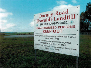
Dorney Road Landfill
Superfund site in Pennsylvania
Distance: Approx. 2332 meters
Latitude and longitude: 40.5247,-75.6538
Dorney Road Landfill is a 27-acre (11 ha) municipal and industrial landfill in Upper Macungie Township and Longswamp Township, Pennsylvania that was polluted with toxic waste from 1952 to 1978. The site is surrounded by rural residences and farmland. The U.S. Environmental Protection Agency (EPA) added the site to the Superfund National Priorities List in 1984.
George F. Schlicher Hotel
United States historic place
Distance: Approx. 3641 meters
Latitude and longitude: 40.51194444,-75.60333333
The George F. Schlicher Hotel is an historic hotel which is located in Alburtis, Pennsylvania in the Lehigh Valley metropolitan area of eastern Pennsylvania. It was added to the National Register of Historic Places in 1992.
The Shoppes at Trexler
Shopping mall in Pennsylvania, U.S.
Distance: Approx. 3607 meters
Latitude and longitude: 40.5499,-75.5923
The Shoppes at Trexler, formerly Trexler Mall, is an open-air shopping center and former enclosed community shopping mall in Trexlertown, Pennsylvania.

Valley Preferred Cycling Center
Distance: Approx. 2121 meters
Latitude and longitude: 40.5475,-75.61055556
The Valley Preferred Cycling Center (VPCC), also known as the Lehigh Valley Velodrome or simply T-Town, is a professional cycling center and a velodrome located in Breinigsville, Pennsylvania. It serves as the Lehigh Valley's main track cycling stadium. The velodrome is operated by Velodrome Fund, a non-profit organization.
Weather in this IP's area
light rain
5 Celsius
5 Celsius
4 Celsius
7 Celsius
1022 hPa
97 %
1022 hPa
1006 hPa
1609 meters
100 %

