162.219.60.66 - IP Lookup: Free IP Address Lookup, Postal Code Lookup, IP Location Lookup, IP ASN, Public IP
Country:
Region:
City:
Location:
Time Zone:
Postal Code:
ISP:
ASN:
language:
User-Agent:
Proxy IP:
Blacklist:
IP information under different IP Channel
ip-api
Country
Region
City
ASN
Time Zone
ISP
Blacklist
Proxy
Latitude
Longitude
Postal
Route
db-ip
Country
Region
City
ASN
Time Zone
ISP
Blacklist
Proxy
Latitude
Longitude
Postal
Route
IPinfo
Country
Region
City
ASN
Time Zone
ISP
Blacklist
Proxy
Latitude
Longitude
Postal
Route
IP2Location
162.219.60.66Country
Region
missouri
City
savannah
Time Zone
America/Chicago
ISP
Language
User-Agent
Latitude
Longitude
Postal
ipdata
Country
Region
City
ASN
Time Zone
ISP
Blacklist
Proxy
Latitude
Longitude
Postal
Route
Popular places and events near this IP address

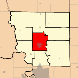
Andrew County, Missouri
County in Missouri, United States
Distance: Approx. 6210 meters
Latitude and longitude: 39.99,-94.8
Andrew County is a county located in the northwestern part of the U.S. state of Missouri. As of the 2020 census, the county had a population of 18,135. Its county seat is Savannah.

Amazonia, Missouri
Village in Missouri, United States
Distance: Approx. 7766 meters
Latitude and longitude: 39.88888889,-94.89277778
Amazonia is a village in Lincoln Township, Andrew County, Missouri, United States. The population was 238 at the 2020 census. It is part of the St.
Savannah, Missouri
City in Missouri, United States
Distance: Approx. 125 meters
Latitude and longitude: 39.93916667,-94.82805556
Savannah is a city and county seat of Andrew County, Missouri, United States. The population was 5,069 at the 2020 census.
Savannah High School (Missouri)
Public school in the United States
Distance: Approx. 1316 meters
Latitude and longitude: 39.94602,-94.81709
Savannah High School is a public secondary school in Savannah, Missouri, United States serving grades 9 to 12. The principal is Mark Weis. The enrollment is just over 800 students.

Jefferson Township, Andrew County, Missouri
Township in Missouri, United States
Distance: Approx. 6984 meters
Latitude and longitude: 39.88555556,-94.78666667
Jefferson Township is one of ten townships in Andrew County, Missouri, United States. As of the 2010 census, its population was 4,646. Jefferson Township was established in 1846, and named after Thomas Jefferson.

Lincoln Township, Andrew County, Missouri
Township in Missouri, United States
Distance: Approx. 8079 meters
Latitude and longitude: 39.92444444,-94.92222222
Lincoln Township is one of ten townships in Andrew County, Missouri, United States. As of the 2010 census, its population was 1,184. Lincoln Township was named after John Lincoln, a member of the Lincoln family who settled the area.

Nodaway Township, Andrew County, Missouri
Township in Missouri, United States
Distance: Approx. 749 meters
Latitude and longitude: 39.94555556,-94.8275
Nodaway Township is one of ten townships in Andrew County, Missouri, United States. As of the 2010 census, its population was 6,738. Nodaway Township was established in 1846, and named after the Nodaway River.

Rochester Township, Andrew County, Missouri
Township in Missouri, United States
Distance: Approx. 9860 meters
Latitude and longitude: 39.92583333,-94.71527778
Rochester Township is one of ten townships in Andrew County, Missouri, United States. As of the 2010 census, its population was 1,182.
Kodiak, Missouri
Unincorporated community in Missouri, U.S.
Distance: Approx. 6335 meters
Latitude and longitude: 39.95194444,-94.75722222
Kodiak is an unincorporated community in Andrew County, in the U.S. state of Missouri.
Wyeth, Missouri
Unincorporated community in Missouri, U.S.
Distance: Approx. 9852 meters
Latitude and longitude: 40.025,-94.80222222
Wyeth is an unincorporated community in Andrew County, in the U.S. state of Missouri. The community is on Missouri Route C approximately 1.5 miles southeast of Rosendale. The One Hundred and Two River flows past about one-half mile to the west.

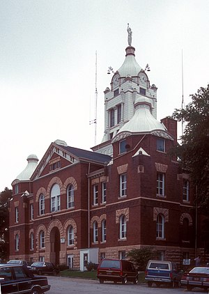
Andrew County Courthouse
United States historic place
Distance: Approx. 267 meters
Latitude and longitude: 39.94138889,-94.82916667
Andrew County Courthouse is a historic courthouse located at Savannah, Andrew County, Missouri. It was built in 1898, and is a two-story, Romanesque Revival style rectangular brick and stone building. It projecting central entrance bay.
Weather in this IP's area
clear sky
-13 Celsius
-20 Celsius
-13 Celsius
-13 Celsius
1036 hPa
45 %
1036 hPa
997 hPa
10000 meters
6.41 m/s
8.53 m/s
323 degree
2 %
