Country:
 USA
USARegion:
City:
Latitude and Longitude:
Time Zone:
Postal Code:
IP information under different IP Channel
ip-api
Country
Region
City
ASN
Time Zone
ISP
Blacklist
Proxy
Latitude
Longitude
Postal
Route
IPinfo
Country
Region
City
ASN
Time Zone
ISP
Blacklist
Proxy
Latitude
Longitude
Postal
Route
MaxMind
Country
Region
City
ASN
Time Zone
ISP
Blacklist
Proxy
Latitude
Longitude
Postal
Route
Luminati
Country
USRegion
in
City
gosport
ASN
Time Zone
America/Indiana/Indianapolis
ISP
SDL-20-AS
Latitude
Longitude
Postal
db-ip
Country
Region
City
ASN
Time Zone
ISP
Blacklist
Proxy
Latitude
Longitude
Postal
Route
ipdata
Country
Region
City
ASN
Time Zone
ISP
Blacklist
Proxy
Latitude
Longitude
Postal
Route
Popular places and events near this IP address
Stinesville, Indiana
Town in Indiana, United States
Distance: Approx. 5194 meters
Latitude and longitude: 39.3,-86.65
Stinesville is a town in Bean Blossom Township, Monroe County, in the U.S. state of Indiana. The population was 203 at the 2020 census. It is part of the Bloomington Metropolitan Statistical Area.
Gosport, Indiana
Town in Indiana, United States
Distance: Approx. 673 meters
Latitude and longitude: 39.34972222,-86.66555556
Gosport is a town in Wayne Township, Owen County, in the U.S. state of Indiana. The population was 826 at the 2010 census. It is part of the Bloomington, Indiana Metropolitan Statistical Area.

Wayne Township, Owen County, Indiana
Township in Indiana, United States
Distance: Approx. 3681 meters
Latitude and longitude: 39.37694444,-86.67472222
Wayne Township is one of thirteen townships in Owen County, Indiana, United States. As of the 2020 census, its population was 1,704 (representing no change from 2010) and it contained 800 housing units.
Mount Tabor, Indiana
Unincorporated community in Indiana, United States
Distance: Approx. 4464 meters
Latitude and longitude: 39.31138889,-86.63333333
Mount Tabor is an unincorporated community in Bean Blossom Township, Monroe County, in the U.S. state of Indiana.
Beanblossom Creek
Stream in Monroe and Brown County, Indiana, U.S.
Distance: Approx. 1762 meters
Latitude and longitude: 39.33027778,-86.65861111
Beanblossom Creek is a stream in Monroe and Brown counties, Indiana, in the United States. The creek drains roughly 91.97 square miles into the two counties of south central Indiana.
Jacks Defeat Creek
Stream in Monroe County, Indiana, U.S.
Distance: Approx. 4086 meters
Latitude and longitude: 39.31361111,-86.63722222
Jacks Defeat Creek is a stream in Monroe County, Indiana, in the United States. It is a tributary of Beanblossom Creek. Jacks Defeat Creek was so named from an incident when two men, Jack Storm and Jack Ketcham were crossing the creek on horseback and both became stuck in the mud.
Silex, Indiana
Unincorporated Community in Indiana, United States
Distance: Approx. 1610 meters
Latitude and longitude: 39.36055556,-86.65972222
Silex is an unincorporated community in the southeast corner of Wayne Township, Owen County, in the U.S. state of Indiana. It lies on County Road 490 North (a.k.a. Lingle Road) just east of Indiana Highway 67, which is a community about ten miles northeast of the city of Spencer, the county seat.

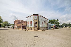
Stinesville Commercial Historic District
Historic district in Indiana, United States
Distance: Approx. 5336 meters
Latitude and longitude: 39.29861111,-86.65083333
Stinesville Commercial Historic District is a national historic district located at Stinesville, Monroe County, Indiana. The district consists of five adjoining limestone commercial buildings in the central business district of Stinesville. The buildings were built between 1886 and 1894, and display elements of Renaissance Revival and Romanesque Revival style architecture.
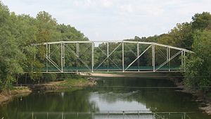
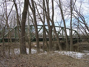
Secrest Ferry Bridge
United States historic place
Distance: Approx. 2111 meters
Latitude and longitude: 39.3325,-86.67638889
Secrest Ferry Bridge is a historic Pennsylvania through truss bridge located in Bean Blossom Township, Monroe County, Indiana and Wayne Township, Owen County, Indiana. It was built by the Lafayette Engineering Co. and Vincennes Bridge Co.

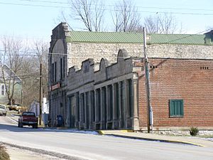
Gosport Historic District
Historic district in Indiana, United States
Distance: Approx. 487 meters
Latitude and longitude: 39.34916667,-86.66333333
Gosport Historic District is a national historic district located at Gosport, Owen County, Indiana. The district encompasses 40 contributing buildings, 1 contributing site, 4 contributing structures, and 4 contributing objects in the central business district and surrounding residential sections of Gosport. It developed between about 1835 and 1952, and includes notable examples of Italianate, Classical Revival, and Bungalow / American Craftsman style architecture.

Dr. H. G. Osgood House
Historic house in Indiana, United States
Distance: Approx. 712 meters
Latitude and longitude: 39.35027778,-86.66555556
Dr. H. G. Osgood House, also known as the Mina Jane Ahlemeyer Property, is a historic home located at Gosport, Owen County, Indiana. The main section of the house was built between about 1860 and 1880, and is a two-story, "T"-plan, Italianate style frame residence.
Secrest-Wampler House
Historic house in Indiana, United States
Distance: Approx. 4924 meters
Latitude and longitude: 39.31638889,-86.70166667
Secrest-Wampler House, also known as the James Secrest House, is a historic home located in Washington Township, Owen County, Indiana. It was built in 1859, and is a two-story, brick I-house with Greek Revival style design elements. It has a one-story rear ell, and the front facade features a two-story portico.
Weather in this IP's area
broken clouds
21 Celsius
22 Celsius
20 Celsius
23 Celsius
1013 hPa
100 %
1013 hPa
993 hPa
10000 meters
0.66 m/s
0.83 m/s
75 degree
80 %
07:31:05
19:50:15