162.219.169.233 - IP Lookup: Free IP Address Lookup, Postal Code Lookup, IP Location Lookup, IP ASN, Public IP
Country:
Region:
City:
Location:
Time Zone:
Postal Code:
IP information under different IP Channel
ip-api
Country
Region
City
ASN
Time Zone
ISP
Blacklist
Proxy
Latitude
Longitude
Postal
Route
Luminati
Country
ASN
Time Zone
America/Chicago
ISP
ATC-INTERNET
Latitude
Longitude
Postal
IPinfo
Country
Region
City
ASN
Time Zone
ISP
Blacklist
Proxy
Latitude
Longitude
Postal
Route
IP2Location
162.219.169.233Country
Region
new york
City
saratoga springs
Time Zone
America/New_York
ISP
Language
User-Agent
Latitude
Longitude
Postal
db-ip
Country
Region
City
ASN
Time Zone
ISP
Blacklist
Proxy
Latitude
Longitude
Postal
Route
ipdata
Country
Region
City
ASN
Time Zone
ISP
Blacklist
Proxy
Latitude
Longitude
Postal
Route
Popular places and events near this IP address

Clifton Park, New York
Town in New York, United States
Distance: Approx. 2220 meters
Latitude and longitude: 42.86666667,-73.81666667
Clifton Park is a suburban town in Saratoga County, New York, United States. It is the largest municipality in the county, with a 2020 population of 38,029, according to the 2020 census. As such, it is the largest municipality in New York state east of Syracuse and north of Schenectady.

Halfmoon, New York
Town in New York, United States
Distance: Approx. 4647 meters
Latitude and longitude: 42.85666667,-73.7425
Halfmoon is a town in Saratoga County, New York, United States. The population was 25,662 at the 2020 census. The town is apparently named for the shape of the lower elevation land north of the junction of the Hudson and Mohawk Rivers.
Shenendehowa Central School District
School district in the U.S. state of New York
Distance: Approx. 1193 meters
Latitude and longitude: 42.8621657,-73.8004886
The Shenendehowa Central School District, often shortened to Shen, is a public school district located in New York's Capital District. The district's 232-acre (0.94 km2) main campus is located off NY 146 in Clifton Park, and is home to eight of the district's 12 schools, in five buildings. The remaining four schools are called "neighborhood elementary schools" and are located throughout the district in three buildings.
Shenendehowa High School
Public high school in Clifton Park, New York, United States
Distance: Approx. 1193 meters
Latitude and longitude: 42.8621657,-73.8004886
Shenendehowa High School (often shortened to Shen High School) is a public high school in Clifton Park, New York, United States. It is part of the Shenendehowa Central School District. Students are separated between two buildings (East and West) by their grade levels.

Clifton Park Center
Shopping mall in Clifton Park, New York
Distance: Approx. 1850 meters
Latitude and longitude: 42.85833333,-73.77833333
Clifton Park Center, formerly known as the Clifton Country Mall, is a large shopping center, located in Clifton Park, New York. As of 2022, the mall currently maintains the traditional chain anchors Boscov's, JCPenney, and a Marshalls and HomeGoods combo. The mall features 72 stores and a food court.

Clifton Park Center Baptist Church and Cemetery
Historic site in Saratoga County, New York
Distance: Approx. 2803 meters
Latitude and longitude: 42.85861111,-73.83194444
Clifton Park Center Baptist Church and Cemetery is a historic Baptist church and cemetery at 713 Clifton Park Center Road in Clifton Park Center, Saratoga County, New York. It was built in 1837 and is a rectangular, gable-roofed brick church in a vernacular Greek Revival style. The adjacent cemetery is surrounded by a cast and wrought iron picket fence and gate.

Clifton Park Hotel
United States historic place
Distance: Approx. 2798 meters
Latitude and longitude: 42.86583333,-73.77083333
Clifton Park Hotel is a historic hotel located at Clifton Park and Halfmoon in Saratoga County, New York. It was first erected in the 1820s and is a 2-story, timber-framed building sheathed in clapboards and topped by a gable roof. A massive, 2-story wood portico / piazza was added in the 1840s, along with a 1+1⁄2-story, two-bay, frame addition.

Grooms Tavern Complex
Historic commercial building in New York, United States
Distance: Approx. 4173 meters
Latitude and longitude: 42.83472222,-73.84472222
Grooms Tavern Complex is a historic tavern located at Grooms Corners in Saratoga County, New York. The complex consists of the tavern, a wagon and blacksmith shop, and a frame privy. The tavern building was built about 1825 and is a 2-story, timber-framed, gable-roofed building in a vernacular Federal style.

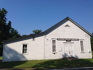
Mohawk Valley Grange Hall
United States historic place
Distance: Approx. 4165 meters
Latitude and longitude: 42.83333333,-73.84361111
Mohawk Valley Grange Hall, also known as Union Hall and Moser Hall, is a historic Grange hall located near Grooms Corners, Saratoga County, New York. It was built in 1896, and is a 1 1/2-story, three bay by four bay, timber frame building. It sits on a dry lad stone foundation and has a steep gable roof.
Congregation Beth Shalom (Clifton Park, New York)
Unaffiliated synagogue in upstate New York, US
Distance: Approx. 2342 meters
Latitude and longitude: 42.857609,-73.82646
Congregation Beth Shalom is an unaffiliated Jewish congregation and synagogue, located at 688 Clifton Park Center Road, in Clifton Park, New York, in the United States. It is the only synagogue in southern Saratoga County. According to its own report, in 2016 the congregation was losing members.
Clifton Gardens, New York
Census-designated place in New York, United States
Distance: Approx. 1603 meters
Latitude and longitude: 42.84555556,-73.78111111
Clifton Gardens is a neighborhood and census-designated place (CDP) within the town of Clifton Park, Saratoga County, New York, United States. It was first listed as a CDP prior to the 2020 census. The community is in southern Saratoga County, in the eastern part of Clifton Park.
Clifton Knolls-Mill Creek, New York
Census-designated place in New York, United States
Distance: Approx. 878 meters
Latitude and longitude: 42.84694444,-73.80777778
Clifton Knolls-Mill Creek is a census-designated place (CDP) within the town of Clifton Park, Saratoga County, New York, United States. It was first listed as a CDP prior to the 2020 census. The community is in southern Saratoga County, southeast of the center of Clifton Park.
Weather in this IP's area
overcast clouds
-2 Celsius
-4 Celsius
-3 Celsius
-0 Celsius
1017 hPa
82 %
1017 hPa
1004 hPa
10000 meters
2.06 m/s
170 degree
100 %