162.218.42.164 - IP Lookup: Free IP Address Lookup, Postal Code Lookup, IP Location Lookup, IP ASN, Public IP
Country:
Region:
City:
Location:
Time Zone:
Postal Code:
ISP:
ASN:
language:
User-Agent:
Proxy IP:
Blacklist:
IP information under different IP Channel
ip-api
Country
Region
City
ASN
Time Zone
ISP
Blacklist
Proxy
Latitude
Longitude
Postal
Route
db-ip
Country
Region
City
ASN
Time Zone
ISP
Blacklist
Proxy
Latitude
Longitude
Postal
Route
IPinfo
Country
Region
City
ASN
Time Zone
ISP
Blacklist
Proxy
Latitude
Longitude
Postal
Route
IP2Location
162.218.42.164Country
Region
minnesota
City
madison
Time Zone
America/Chicago
ISP
Language
User-Agent
Latitude
Longitude
Postal
ipdata
Country
Region
City
ASN
Time Zone
ISP
Blacklist
Proxy
Latitude
Longitude
Postal
Route
Popular places and events near this IP address

Correll, Minnesota
City in Minnesota, United States
Distance: Approx. 7363 meters
Latitude and longitude: 45.23194444,-96.16194444
Correll is a city in Big Stone County, Minnesota, United States. The population was 26 at the 2020 census. Correll was named for David N Correll, a railroad official who founded the city in 1881.

Bellingham, Minnesota
City in Minnesota, United States
Distance: Approx. 9495 meters
Latitude and longitude: 45.13638889,-96.28416667
Bellingham is a city in Lac qui Parle County, Minnesota, United States. The population was 168 at the 2010 census.
Lake Shore Township, Lac qui Parle County, Minnesota
Township in Minnesota, United States
Distance: Approx. 2904 meters
Latitude and longitude: 45.14027778,-96.16555556
Lake Shore Township is a township in Lac qui Parle County, Minnesota, United States. The population was 239 at the 2000 census. Lake Shore Township was organized in 1879, and named for its location near a marshy lake.

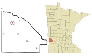
Louisburg, Minnesota
Hamlet in Minnesota, United States
Distance: Approx. 186 meters
Latitude and longitude: 45.16444444,-96.17111111
Louisburg is a hamlet in Lac qui Parle County, Minnesota, United States. The population was 47 at the 2010 census.

Pomme de Terre River (Minnesota)
River in Minnesota, United States
Distance: Approx. 6670 meters
Latitude and longitude: 45.17583333,-96.08694444
The Pomme de Terre River is a 125-mile-long (201 km) tributary of the Minnesota River in western Minnesota in the United States. Via the Minnesota River, it is part of the watershed of the Mississippi River, draining an area of 875 square miles (2,270 km2) in an agricultural region. The headwaters region of the Pomme de Terre River is the northernmost extremity of the Minnesota River's watershed.
Weather in this IP's area
overcast clouds
-22 Celsius
-29 Celsius
-22 Celsius
-22 Celsius
1035 hPa
85 %
1035 hPa
992 hPa
10000 meters
4.48 m/s
10.02 m/s
325 degree
100 %