Country:
Region:
City:
Latitude and Longitude:
Time Zone:
Postal Code:
IP information under different IP Channel
ip-api
Country
Region
City
ASN
Time Zone
ISP
Blacklist
Proxy
Latitude
Longitude
Postal
Route
Luminati
Country
Region
ia
City
riverside
ASN
Time Zone
America/Chicago
ISP
LCOM-NET
Latitude
Longitude
Postal
IPinfo
Country
Region
City
ASN
Time Zone
ISP
Blacklist
Proxy
Latitude
Longitude
Postal
Route
db-ip
Country
Region
City
ASN
Time Zone
ISP
Blacklist
Proxy
Latitude
Longitude
Postal
Route
ipdata
Country
Region
City
ASN
Time Zone
ISP
Blacklist
Proxy
Latitude
Longitude
Postal
Route
Popular places and events near this IP address

Harper, Iowa
City in Iowa, United States
Distance: Approx. 8093 meters
Latitude and longitude: 41.36361111,-92.05083333
Harper is a city in Keokuk County, Iowa, United States. The population was 118 at the time of the 2020 census.

Keota, Iowa
City in Iowa, United States
Distance: Approx. 1931 meters
Latitude and longitude: 41.365,-91.95333333
Keota is a city in Keokuk and Washington counties, Iowa, United States. The population was 897 at the time of the 2020 census.

Saints Peter and Paul Roman Catholic Church Historic District
Historic district in Iowa, United States
Distance: Approx. 6289 meters
Latitude and longitude: 41.30535,-92.00594722
Saints Peter and Paul Roman Catholic Church is a former parish church of the Diocese of Davenport. The church is located southeast of Harper, Iowa, United States, in Clear Creek Township, Keokuk County. The church building was individually listed on the National Register of Historic Places in 1986.

C.F. and Mary Singmaster House
Historic house in Iowa, United States
Distance: Approx. 4242 meters
Latitude and longitude: 41.38138889,-91.98027778
The C.F. and Mary Singmaster House, also known as Maplehurst Ranch, or more simply Maplehurst, is located near Keota, Iowa, United States. C.F. Singmaster, a Pennsylvania native, moved to Keokuk County with his parents in 1843 and settled near Talleyrand, south of Keota. His father Samuel established the home farm, Singmaster Ranch.
Dutch Creek Township, Washington County, Iowa
Township in Washington County, Iowa, U.S.
Distance: Approx. 8727 meters
Latitude and longitude: 41.2861,-91.8919
Dutch Creek Township is a township in Washington County, Iowa, United States.
Seventy-Six Township, Washington County, Iowa
Township in Washington County, Iowa, U.S.
Distance: Approx. 5725 meters
Latitude and longitude: 41.3742,-91.8975
Seventy-Six Township is a township in Washington County, Iowa, United States.
Keota Community School District
Public school district in Keota, Iowa, United States
Distance: Approx. 2376 meters
Latitude and longitude: 41.369,-91.953
The Keota Community School District, or Keota Community Schools, is a rural public school district serving the towns of Keota and Harper and surrounding areas in eastern Keokuk and western Washington counties. The school, which serves all grade levels PreK-12 in one building, is located at 505 N Ellis Street in Keota. The school's mascot is the Eagle.

Ramsey Building
United States historic place
Distance: Approx. 1775 meters
Latitude and longitude: 41.36358333,-91.95330556
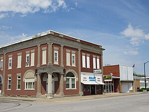
The Ramsey Building is a historic building located in Keota, Iowa, United States. Eben J. Ramsey had the two-story, brick, Romanesque Revival commercial building constructed in 1895. Its significance is derived from its association with both the furniture and funeral business.
Weather in this IP's area
few clouds
7 Celsius
5 Celsius
7 Celsius
8 Celsius
1014 hPa
90 %
1014 hPa
985 hPa
10000 meters
3.47 m/s
7.61 m/s
315 degree
14 %
06:45:55
16:57:03