Country:
 USA
USARegion:
City:
Latitude and Longitude:
Time Zone:
Postal Code:
IP information under different IP Channel
ip-api
Country
Region
City
ASN
Time Zone
ISP
Blacklist
Proxy
Latitude
Longitude
Postal
Route
IPinfo
Country
Region
City
ASN
Time Zone
ISP
Blacklist
Proxy
Latitude
Longitude
Postal
Route
MaxMind
Country
Region
City
ASN
Time Zone
ISP
Blacklist
Proxy
Latitude
Longitude
Postal
Route
Luminati
Country
USRegion
al
City
oxford
ASN
Time Zone
America/Chicago
ISP
UNITI-FIBER
Latitude
Longitude
Postal
db-ip
Country
Region
City
ASN
Time Zone
ISP
Blacklist
Proxy
Latitude
Longitude
Postal
Route
ipdata
Country
Region
City
ASN
Time Zone
ISP
Blacklist
Proxy
Latitude
Longitude
Postal
Route
Popular places and events near this IP address

Clay County, Alabama
County in Alabama, United States
Distance: Approx. 4252 meters
Latitude and longitude: 33.27222222,-85.86111111
Clay County is a county in the east central part of the U.S. state of Alabama. As of the 2020 census the population was 14,236. Its county seat is Ashland.
Ashland, Alabama
City in and county seat of Clay County, Alabama
Distance: Approx. 2937 meters
Latitude and longitude: 33.272206,-85.836925
Ashland is a city in Clay County, Alabama, United States. The population was 2,037 at the 2010 census. The city is the county seat of Clay County.

Lineville, Alabama
City in Alabama, United States
Distance: Approx. 9724 meters
Latitude and longitude: 33.31055556,-85.75444444
Lineville is a city in Clay County, Alabama, United States. At the 2020 census, the population was 2,489.

Ashland/Lineville Airport
Airport
Distance: Approx. 4410 meters
Latitude and longitude: 33.28416667,-85.80916667
Ashland/Lineville Airport (FAA LID: 26A) is a county-owned public-use airport located 2 nautical miles (4 km) northeast of the central business district of Ashland, a town in Clay County, Alabama, United States. According to the FAA's National Plan of Integrated Airport Systems for 2009–2013, it is categorized as a general aviation facility.
Hugo Black House
Historic house in Alabama, United States
Distance: Approx. 1779 meters
Latitude and longitude: 33.26222222,-85.83333333
The Hugo Black House was a historic house in Ashland, Clay County, Alabama, United States. The one-and-a-half-story, wood-frame residence was purchased by William LaFayette and Martha Black in 1893. They were the parents of politician and U.S. Supreme Court jurist Hugo Black, who grew up in the house.
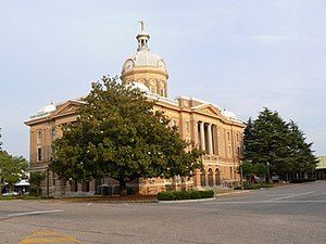
Clay County Courthouse (Alabama)
United States historic place
Distance: Approx. 3114 meters
Latitude and longitude: 33.27416667,-85.83583333
The Clay County Courthouse is a historic courthouse building in Ashland, Alabama, United States. The Classical Revival-style building has served as the county courthouse since its completion in 1906. Notable characteristics include its large dome, with clocks inset on four sides, and cupola surmounted by a statuary representing justice.

Central High School of Clay County
Comprehensive public high school in Lineville, Alabama, United States
Distance: Approx. 5942 meters
Latitude and longitude: 33.289624,-85.787603
The Central High School of Clay County, or Clay Central, is a public, 5A division school located in Lineville in east central Alabama. The school was opened in 2012 and is the largest school in the eastern region.
Weather in this IP's area
clear sky
3 Celsius
2 Celsius
2 Celsius
4 Celsius
1031 hPa
63 %
1031 hPa
990 hPa
10000 meters
1.84 m/s
5.08 m/s
74 degree
06:50:18
18:06:04