Country:
Region:
City:
Latitude and Longitude:
Time Zone:
Postal Code:
IP information under different IP Channel
ip-api
Country
Region
City
ASN
Time Zone
ISP
Blacklist
Proxy
Latitude
Longitude
Postal
Route
Luminati
Country
Region
fl
City
marcoisland
ASN
Time Zone
America/New_York
ISP
ORLANDOTELCO
Latitude
Longitude
Postal
IPinfo
Country
Region
City
ASN
Time Zone
ISP
Blacklist
Proxy
Latitude
Longitude
Postal
Route
db-ip
Country
Region
City
ASN
Time Zone
ISP
Blacklist
Proxy
Latitude
Longitude
Postal
Route
ipdata
Country
Region
City
ASN
Time Zone
ISP
Blacklist
Proxy
Latitude
Longitude
Postal
Route
Popular places and events near this IP address

Goodland, Florida
Census-designated place in Florida
Distance: Approx. 4375 meters
Latitude and longitude: 25.92444444,-81.64694444
Goodland is a census-designated place (CDP) in Collier County, Florida, United States. The population was 312 at the 2020 census, up from 267 at the 2010 census. It is part of the Naples–Marco Island Metropolitan Statistical Area.

Marco Island, Florida
City in Florida, United States
Distance: Approx. 5873 meters
Latitude and longitude: 25.9725,-81.72888889
Marco Island is a city and barrier island in Collier County, Florida, 20 miles (32 km) south of Naples on the Gulf Coast of the United States. It is the largest barrier island in Southwest Florida's Ten Thousand Islands area, which extends southerly to Cape Sable. Marco Island is home to an affluent beach community with resort amenities.

Key Marco
Archaeological site in Florida, US
Distance: Approx. 4828 meters
Latitude and longitude: 25.9594,-81.7281
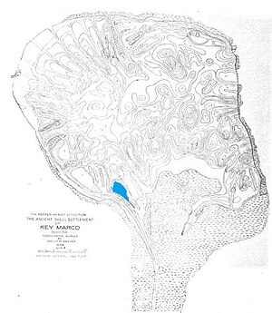
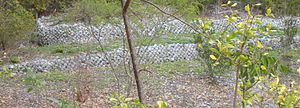
Key Marco was an archaeological site (8CR48) consisting of a large shell works island next to Marco Island, Florida. A small pond on Key Marco, now known as the "Court of the Pile Dwellers" (8CR49), was excavated in 1896 by the Smithsonian Institution's Pepper-Hearst Expedition, led by Frank Hamilton Cushing. Cushing recovered more than 1,000 wooden artifacts from the pond, the largest number of wooden artifacts from any prehistoric archaeological site in the eastern United States.

Capt. John Foley Horr House
Historic house in Florida, United States
Distance: Approx. 3351 meters
Latitude and longitude: 25.90333333,-81.68777778
The Capt. John Foley Horr House is the historic residence of Captain John Foley Horr on the southern portion of Marco Island, Florida. It is located at the north side of Whiskey Creek Drive on Key Marco (formerly known as Horr's Island).
Rookery Bay National Estuarine Research Reserve
Distance: Approx. 6233 meters
Latitude and longitude: 25.971621,-81.735
Rookery Bay National Estuarine Research Reserve protects 110,000 acres of coastal lands and waters at the northern end of the Ten Thousand Islands on the gulf coast of Florida, representing one of the few remaining undisturbed mangrove estuaries in North America. Its ecosystem is a prime example of a nearly pristine subtropical mangrove forested estuary. It is located in the West Florida subregion of the West Indian Biogeographic Region.
Otter Mound Preserve
Shell mound nature preserve in Florida, USA
Distance: Approx. 2587 meters
Latitude and longitude: 25.91173,-81.69883
Otter Mound is located at 1831 Addison Court, Marco Island. The 2.45 acre preserve is located in southwestern Collier County in a residential area of Marco Island, known locally as the Indian Hills section. The preserve is maintained by Collier County.

Marco Island Historical Museum
Distance: Approx. 2643 meters
Latitude and longitude: 25.9332,-81.7159
Marco Island Historical Museum is a history museum on Marco Island, Florida, Collier County, Florida. It is operated by the Marco Island Historical Society and is part of the Collier County Museum System. Its exhibitions include information on the Calusa Indians and the history of development on Marco Island.
S.S. Jolley Bridge
Bridge in Florida, United States
Distance: Approx. 3926 meters
Latitude and longitude: 25.96363,-81.7097
S.S. Jolley Bridge (also known as Judge S.S. Jolley Bridge) is a bridge located in Collier County, Florida connecting Marco Island with the mainland in Naples. The bridge is a good location for fishing.
Coconut Island (Florida)
Island in Florida, United States
Distance: Approx. 7007 meters
Latitude and longitude: 25.97111111,-81.74555556
Coconut island was a river island in the mouth of the Marco River in Collier County, Florida.
Marco Island Academy
Charter school
Distance: Approx. 1171 meters
Latitude and longitude: 25.9336,-81.6778
Marco Island Academy is a public charter high school (9-12) located in Marco Island, Collier County, Florida.
Isles of Capri, Florida
Distance: Approx. 6684 meters
Latitude and longitude: 25.98277778,-81.7275
Isles of Capri is an island community located in unincorporated Collier County, Florida. The isles are a grouping of four mangrove islands that were developed and connected in the 1950s. The isles are connected by Capri Boulevard, and can be accessed from nearby SR 951 (Collier Boulevard).
Stan Gober Memorial Bridge
Bridge in Goodland, Florida
Distance: Approx. 3684 meters
Latitude and longitude: 25.9329,-81.6527
The Stan Gober Memorial Bridge (previously known as the Goodland Bridge) is a bridge near Goodland, Florida connecting the east side of Marco Island with main land Collier County. The bridge is one of two bridges connecting Marco Island with the main land, with the other being the S.S. Jolley Bridge further west. The is 55 feet tall and carries two lanes of County Road 92 (San Marco Road) over the Marco Channel.
Weather in this IP's area
broken clouds
25 Celsius
26 Celsius
24 Celsius
25 Celsius
1012 hPa
99 %
1012 hPa
1012 hPa
10000 meters
7.41 m/s
12.59 m/s
92 degree
83 %
06:38:58
17:41:52
