162.212.202.166 - IP Lookup: Free IP Address Lookup, Postal Code Lookup, IP Location Lookup, IP ASN, Public IP
Country:
 Canada
Region:
City:
Location:
Time Zone:
Postal Code:
ISP:
ASN:
language:
User-Agent:
Proxy IP:
Blacklist:
IP information under different IP Channel
ip-api
Country
Region
City
ASN
Time Zone
ISP
Blacklist
Proxy
Latitude
Longitude
Postal
Route
db-ip
Country
Region
City
ASN
Time Zone
ISP
Blacklist
Proxy
Latitude
Longitude
Postal
Route
IPinfo
Country
Region
City
ASN
Time Zone
ISP
Blacklist
Proxy
Latitude
Longitude
Postal
Route
IP2Location
162.212.202.166Country
caRegion
ontario
City
etobicoke
Time Zone
America/Toronto
ISP
Language
User-Agent
Latitude
Longitude
Postal
ipdata
Country
Region
City
ASN
Time Zone
ISP
Blacklist
Proxy
Latitude
Longitude
Postal
Route
Popular places and events near this IP address

Etobicoke—Lakeshore (federal electoral district)
Federal electoral district in Ontario, Canada
Distance: Approx. 460 meters
Latitude and longitude: 43.61,-79.54
Etobicoke—Lakeshore (formerly known as Lakeshore and Toronto—Lakeshore) is a federal electoral district in Ontario, Canada, that has been represented in the House of Commons of Canada since 1968. It covers the southern part of the Etobicoke portion of Toronto on the shore of Lake Ontario including the former 'Lakeshore Municipalities' of Mimico, New Toronto and Long Branch. This riding has been a destination for Slavic immigrants.
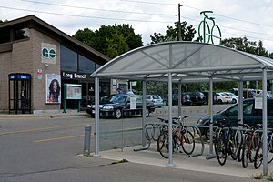
Long Branch GO Station
Railway station in Toronto, Canada
Distance: Approx. 2199 meters
Latitude and longitude: 43.59194444,-79.54555556
Long Branch GO Station is a GO Transit railway station in Toronto, Ontario, Canada. It is one of the Lakeshore West line stations, serving the Long Branch neighbourhood. Being one of the original GO Stations built in 1967, it is now scheduled for modernization.

Sherway Gardens
Shopping mall
Distance: Approx. 959 meters
Latitude and longitude: 43.61183889,-79.55709722
Sherway Gardens (corporately known as CF Sherway Gardens) is a large retail shopping mall in Toronto, Ontario, Canada. The mall is located 17 kilometres (11 mi) west of Downtown Toronto, near the interchange of Highway 427 with the Queen Elizabeth Way and Gardiner Expressway. Opened in 1971, the mall originally covered 850,000 square feet (79,000 m2) in an S-shaped configuration and contained 127 stores.

Alderwood, Toronto
Neighbourhood in Toronto, Ontario, Canada
Distance: Approx. 613 meters
Latitude and longitude: 43.6075,-79.54027778
Alderwood is a neighbourhood in the city of Toronto, Ontario, Canada. It is in the western section of Toronto, within the district of Etobicoke. It is bounded by the Etobicoke Creek to the west, the Gardiner Expressway to the north, the CPR railway to the east and the CNR railway to the south.

Toronto Golf Club
Private golf club in Mississauga, Ontario
Distance: Approx. 2199 meters
Latitude and longitude: 43.593,-79.554
The Toronto Golf Club is a private golf club in Mississauga, Ontario, a suburban municipality to the west of Toronto. Established in Toronto in 1876, it is the third-oldest golf club in North America, after the Royal Montreal Golf Club and the Royal Quebec Golf Club. The Toronto Golf Club adopted its current name in 1909 and moved to its present location in 1913.

Vincent Massey Junior School
Public elementary school in Etobicoke, Toronto, Ontario, Canada
Distance: Approx. 2061 meters
Latitude and longitude: 43.59777,-79.52836
Vincent Massey Junior School (Vincent Massey JS, VMJS or Massey), formerly Daisy Avenue Public School is located at 68 Daisy Avenue in the Long Branch area of Etobicoke, Ontario, Canada. This school has kindergarten through grade five. The property was owned by the Toronto District School Board and was sold to a developer in 2017.
Etobicoke—Lakeshore (provincial electoral district)
Provincial electoral district in Ontario, Canada
Distance: Approx. 460 meters
Latitude and longitude: 43.61,-79.54
Etobicoke—Lakeshore is a provincial electoral district in Toronto, Ontario, Canada. It elects one member to the Legislative Assembly of Ontario. It was created in 1987 from Lakeshore.

Little Etobicoke Creek
River in Ontario, Canada
Distance: Approx. 1782 meters
Latitude and longitude: 43.61027778,-79.56722222
Little Etobicoke Creek is a small river in Mississauga, Regional Municipality of Peel in the Greater Toronto Area of Ontario, Canada. It is in the Great Lakes Basin and is a right tributary of Etobicoke Creek, which flows to Lake Ontario.

Honeydale Mall
Shopping mall in Ontario, Canada
Distance: Approx. 1975 meters
Latitude and longitude: 43.6294,-79.54679
Honeydale Mall was a community shopping mall in Toronto, Ontario, Canada. It was located at the intersection of Dundas Street and The East Mall Crescent (the latter being a link connecting the grade-separated roads, The East Mall and Dundas Street). It served the Eatonville neighbourhood of Etobicoke district.

Alderwood Collegiate Institute
High school in Alderwood, Etobicoke, Ontario, Canada
Distance: Approx. 946 meters
Latitude and longitude: 43.60944444,-79.53388889
Alderwood Collegiate Institute (Alderwood CI, ACI, or Alderwood), named Alderwood Secondary School and Alderwood High School prior is a former public high school that existed from 1955 to 1983 under the governance of the Etobicoke Board of Education (now part of the Toronto District School Board) and that served the Alderwood neighbourhood in the former city of Etobicoke in Toronto, Ontario, Canada. The school merged with New Toronto Secondary School to form Lakeshore Collegiate Institute in 1983. The portion of the Alderwood property was transferred to the TDSB's realtor arm, Toronto Lands Corporation (TLC) in 2011 and sold to Urbancorp, a housing developer in August 2012.

Long Branch Loop
Streetcar loop in Toronto, Canada
Distance: Approx. 2231 meters
Latitude and longitude: 43.59166667,-79.54444444
Long Branch Loop is the westernmost streetcar stop within the Toronto streetcar system, operated by the Toronto Transit Commission (TTC). It is located in the Long Branch neighbourhood in southwestern Toronto, close to the boundary with Mississauga. Long Branch Loop is the western terminus for four streetcar routes but is principally served by the 507 Long Branch route.
Long Branch Racetrack
Canadian horse-racing track
Distance: Approx. 1696 meters
Latitude and longitude: 43.610599,-79.524208
Long Branch Racetrack was a horse-racing facility in Etobicoke, Ontario, Canada. It was situated in Etobicoke, then a township, just north of the village of Long Branch and just west of the city of Toronto. It operated from 1924 until 1955 at a location west of Kipling Avenue, north of Horner Avenue and south of Evans Avenue.
Weather in this IP's area
broken clouds
-5 Celsius
-12 Celsius
-6 Celsius
-5 Celsius
1024 hPa
73 %
1024 hPa
1009 hPa
10000 meters
7.2 m/s
10.8 m/s
80 degree
75 %