162.211.52.93 - IP Lookup: Free IP Address Lookup, Postal Code Lookup, IP Location Lookup, IP ASN, Public IP
Country:
 USA
USARegion:
City:
Location:
Time Zone:
Postal Code:
ISP:
ASN:
language:
User-Agent:
Proxy IP:
Blacklist:
IP information under different IP Channel
ip-api
Country
Region
City
ASN
Time Zone
ISP
Blacklist
Proxy
Latitude
Longitude
Postal
Route
db-ip
Country
Region
City
ASN
Time Zone
ISP
Blacklist
Proxy
Latitude
Longitude
Postal
Route
IPinfo
Country
Region
City
ASN
Time Zone
ISP
Blacklist
Proxy
Latitude
Longitude
Postal
Route
IP2Location
162.211.52.93Country
usRegion
california
City
north hollywood
Time Zone
America/Los_Angeles
ISP
Language
User-Agent
Latitude
Longitude
Postal
ipdata
Country
Region
City
ASN
Time Zone
ISP
Blacklist
Proxy
Latitude
Longitude
Postal
Route
Popular places and events near this IP address
North Hollywood shootout
1997 bank robbery and subsequent shootout between bank robbers and police
Distance: Approx. 1916 meters
Latitude and longitude: 34.19194444,-118.39638889
The North Hollywood shootout, also known as the Battle of North Hollywood, was a confrontation between two heavily armed and armored bank robbers, Larry Phillips Jr. and Emil Mătăsăreanu, and police officers in the North Hollywood neighborhood of Los Angeles on February 28, 1997. Both robbers were killed, twelve police officers and eight civilians were injured, and numerous vehicles and other property were damaged or destroyed by the nearly 2,000 rounds of ammunition fired by the robbers and police.

John H. Francis Polytechnic High School
Comprehensive high school in Sun Valley, , California, United States
Distance: Approx. 1647 meters
Latitude and longitude: 34.2227818,-118.4067144
John H. Francis Polytechnic High School is a secondary school located in the Sun Valley neighborhood of Los Angeles, California, United States. It serves grades 9 through 12 and is a part of the Los Angeles Unified School District. Despite its name, Polytechnic is a comprehensive high school.

San Fernando Road
Major street in the City and County Los Angeles
Distance: Approx. 2903 meters
Latitude and longitude: 34.22777778,-118.38138889
San Fernando Road is a major street in the City of Los Angeles and Los Angeles County. Within the Burbank city limits it is signed as San Fernando Boulevard, and north of Newhall Pass it is signed as The Old Road. It was previously designated as Business Loop 5 in the 1970s.
Dave's Room
California recording studio
Distance: Approx. 2018 meters
Latitude and longitude: 34.22182,-118.38777
Dave's Room, previously known as Mama Jo's Recording Studio, is a recording studio in North Hollywood, California.

Grace Community Church
Christian church in Los Angeles, California
Distance: Approx. 2270 meters
Latitude and longitude: 34.221093,-118.421799
Grace Community Church is a non-denominational, evangelical megachurch founded in 1956 and located in Sun Valley, a neighborhood in the San Fernando Valley of Los Angeles. Speaker and radio evangelist John MacArthur is the senior pastor of Grace Community Church. As of 2008, the average weekly attendance was 8,258.
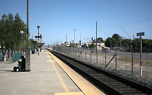
Sun Valley station
Railway station in Los Angeles, California, United States
Distance: Approx. 3066 meters
Latitude and longitude: 34.2225,-118.37388889
Sun Valley station is a Metrolink train station located in the community of Sun Valley in the city of Los Angeles, California. It is served by Metrolink's Antelope Valley Line between Los Angeles Union Station and Lancaster station. Sun Valley station is served by 30 Metrolink Antelope Valley Line trains (15 in each direction) each weekday.
Research Video
Distance: Approx. 820 meters
Latitude and longitude: 34.20355,-118.39579
Research Video was a music footage library operating from North Hollywood, Los Angeles. The company was formed in 1984 by partners John Delgatto and Paul Surratt. Paul Surratt was also an ex-Shilos member, a folk group headed by Gram Parsons.
The Master's Seminary
Division of The Master's University
Distance: Approx. 2203 meters
Latitude and longitude: 34.22055556,-118.42138889
The Master's Seminary (TMS) is the graduate seminary division of The Master's University and Seminary and is located on the campus of Grace Community Church in Sun Valley, California. It is accredited by the WASC Senior College and University Commission (WSCUC).

Area codes 818 and 747
Telephone area codes in Los Angeles County, California, U.S.
Distance: Approx. 2853 meters
Latitude and longitude: 34.2334,-118.4093
Area codes 818 and 747 are telephone area codes in the North American Numbering Plan (NANP) for the San Fernando Valley region of Los Angeles County in the U.S. state of California. Area code 818 was created in a split from area code 213 on January 7, 1984. On June 14, 1997, 818 was reduced in size to create a separate numbering plan area (NPA) for most of the San Gabriel Valley with area code 626.
Sun Valley High School (California)
High school in Los Angeles, California , United States
Distance: Approx. 3021 meters
Latitude and longitude: 34.235,-118.396
Sun Valley High School was a four-year high school in Sun Valley, Los Angeles and was part of the Los Angeles Unified School District. Sun Valley High School was home to over 600 students and 24 staff members and offers Project Lead the Way Engineering and a Media Arts/Film Production program along with Advanced Placement courses.
NoHo West
Mixed-use complex in Los Angeles
Distance: Approx. 3127 meters
Latitude and longitude: 34.18111111,-118.39444444
NOHO West is a mixed-use complex in North Hollywood, Los Angeles. Developed on the 25-acre site (10 ha) of the former Laurel Plaza regional shopping mall, the development includes residential units, commercial offices and pedestrian-oriented shops and restaurants. Groundbreaking for NOHO West began in April 2017.

Valley Plaza
Shopping center in North Hollywood, Los Angeles
Distance: Approx. 2409 meters
Latitude and longitude: 34.1871795,-118.3973922
Valley Plaza was a shopping center in North Hollywood, Los Angeles, one of the first in the San Fernando Valley, opened in 1951. In the mid-1950s it was reported to be the largest shopping center on the West Coast of the United States and the third-largest in the country. It was located along Laurel Canyon Boulevard from Oxnard to Vanowen, and west along Victory Boulevard.
Weather in this IP's area
clear sky
11 Celsius
10 Celsius
9 Celsius
12 Celsius
1017 hPa
72 %
1017 hPa
976 hPa
10000 meters
2.06 m/s
130 degree