Country:
 USA
USARegion:
City:
Latitude and Longitude:
Postal Code:
Time Zone:
language:
User-Agent:
Proxy IP:
Blacklist:
IP information under different IP Channel
Luminati
162.159.130.236Popular places and events near this IP address
California Institute for Regenerative Medicine
Research institute in California, United States
Distance: Approx. 344 meters
Latitude and longitude: 37.77795833,-122.392525
The California Institute for Regenerative Medicine (CIRM) was created in 2004 after 59% of California voters approved California Proposition 71: the Research and Cures Initiative, which allocated $3 billion to fund stem cell research in California. Institutes dedicated to stem cell research and training exist at Sanford Consortium, University of California, Santa Cruz, Stanford University, University of California Davis, University of California Irvine, University of California San Francisco, University of California Los Angeles and University of Southern California. Nine "Alpha Stem Cell Clinics" have also been established to lead clinical trials for stem cell therapies at City of Hope, University of California San Diego, University of California San Francisco, University of California Davis, a joint clinic at University of California Los Angeles and University of California Irvine, Cedars Sinai, Stanford, and USC/Children’s Hospital Los Angeles.
Dumpville
Historical neighborhood in San Francisco
Distance: Approx. 442 meters
Latitude and longitude: 37.7723,-122.3978
San Francisco's Dumpville was a permanent village along the shores of Mission Bay that existed from the 1860s until 1895. Dumpville was an early refuse site on Southern Pacific Railroad land, a loosely structured community of mostly men, not unlike dump sites across the planet. It was on the shore of Mission Creek, the waters called "poverty lake." Dumpville was a location where poor people lived in makeshift housing and sifted through the trash for items that had some value, cans, cloth, metal, bottles and utensils.

Trocadero Transfer
Distance: Approx. 445 meters
Latitude and longitude: 37.77908333,-122.39788889
The Trocadero Transfer, or The Troc, was an after hours dance club in operation from December 1977 to the late–1990s in San Francisco, California, U.S.. It was located at 520 4th Street at Bryant in the SoMa neighborhood. The club has been compared to Studio 54 in New York City, and their patrons would travel from other cities to attend the party.
King Street Garage
Distance: Approx. 505 meters
Latitude and longitude: 37.77888889,-122.39111111
The King Street Garage was a nightclub located at 174 King Street in San Francisco, California, near the present location of AT&T Park. It was directly adjacent to, and physically connected with, the Club Townsend, another famous nightclub on the other side of the block located at 177 Townsend Street.

San Francisco 4th and King Street station
Train station in San Francisco, California, U.S.
Distance: Approx. 101 meters
Latitude and longitude: 37.77638889,-122.39444444
San Francisco 4th and King Street station (previously 4th & Townsend), also known as the Caltrain Depot, is a train station in the SoMa district of San Francisco, California. It is presently the northern terminus of the Caltrain commuter rail line serving the San Francisco Peninsula and Santa Clara Valley. It is also the eastern terminus of the N Judah and E Embarcadero, as well as a stop along the T Third Street of the Muni network.

China Basin Landing
Distance: Approx. 304 meters
Latitude and longitude: 37.776348,-122.391839
China Basin Landing, now referred to as simply China Basin, is an office complex on the border of the South of Market (SoMa) and Mission Bay areas of San Francisco, California. The complex has 917,000 square feet (85,200 m2) of space. It is the headquarters of Lyft and Dignity Health.

Lefty O'Doul Bridge
Bridge in San Francisco
Distance: Approx. 470 meters
Latitude and longitude: 37.77666667,-122.39
The Lefty O'Doul Bridge (also known as the Third Street Bridge or China Basin Bridge) is a bascule bridge connecting the China Basin and Mission Bay neighborhoods of San Francisco, carrying Third Street across the Mission Creek Channel. It is located directly adjacent to Oracle Park.
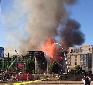
Mission Bay fire
2014 fire in San Francisco, California, US
Distance: Approx. 555 meters
Latitude and longitude: 37.7715,-122.39180556
The China Basin fire was a five-alarm fire that occurred shortly before 5:00 p.m. on March 11, 2014, in the Mission Bay neighborhood of San Francisco, California. The conflagration appeared to completely destroy Block 5, a 172-unit building, part of Mega Blocks 360, a US$227,000,000 apartment complex being developed by San Francisco-based BRE Properties Inc.
Saison (restaurant)
Restaurant in California, United States
Distance: Approx. 498 meters
Latitude and longitude: 37.77952,-122.39225
Saison is a San Francisco restaurant that earned the highest rating of three stars from the Michelin Guide in 2014. It is located in the SoMa district. The founder is Beverage Director and Winemaker for Saison Winery, Mark Bright.

4th and Brannan station
Light rail station in San Francisco, California, US
Distance: Approx. 309 meters
Latitude and longitude: 37.778272,-122.396512
4th and Brannan station is an at-grade Muni Metro light rail station located in the median of 4th Street at Brannan Street in the South of Market (SoMa) district of San Francisco, California. It opened on November 19, 2022, as part of the Central Subway project. The station is served by the T Third Street line which runs between Chinatown and Sunnydale.
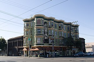
Hotel Utah (San Francisco, California)
Historic building in San Francisco
Distance: Approx. 538 meters
Latitude and longitude: 37.78001,-122.397959
The Hotel Utah is a historic mixed-use building known as a saloon bar, live music venue, and residential hotel, built in 1908 and located in the South of Market neighborhood of San Francisco, California. It is known for its diverse open mic nights, which have historically attracted some people who have later become famous. It is also known as The Utah Inn, The Hotel Utah Saloon, and simply The Utah.
The Canyon (building)
Building in San Francisco, California
Distance: Approx. 501 meters
Latitude and longitude: 37.775647,-122.389512
The Canyon is a 23-story waterfront residential tower in the Mission Rock neighborhood of San Francisco, California. The site was previously a parking lot.
Weather in this IP's area
few clouds
18 Celsius
18 Celsius
13 Celsius
30 Celsius
1011 hPa
74 %
10000 meters
8.23 m/s
340 degree
20 %
09:00:00
12:00:00
The latest IP detection test
- 108.166.35.124
- 99.178.158.148
- 169.207.215.47
- 222.9.65.218
- 113.33.188.155
- 111.163.178.145
- 60.224.183.210
- 226.199.196.151
- 109.62.176.102
- 189.106.36.53