162.13.178.88 - IP Lookup: Free IP Address Lookup, Postal Code Lookup, IP Location Lookup, IP ASN, Public IP
Country:
Region:
City:
Location:
Time Zone:
Postal Code:
ISP:
ASN:
language:
User-Agent:
Proxy IP:
Blacklist:
IP information under different IP Channel
ip-api
Country
Region
City
ASN
Time Zone
ISP
Blacklist
Proxy
Latitude
Longitude
Postal
Route
db-ip
Country
Region
City
ASN
Time Zone
ISP
Blacklist
Proxy
Latitude
Longitude
Postal
Route
IPinfo
Country
Region
City
ASN
Time Zone
ISP
Blacklist
Proxy
Latitude
Longitude
Postal
Route
IP2Location
162.13.178.88Country
Region
england
City
eton
Time Zone
Europe/London
ISP
Language
User-Agent
Latitude
Longitude
Postal
ipdata
Country
Region
City
ASN
Time Zone
ISP
Blacklist
Proxy
Latitude
Longitude
Postal
Route
Popular places and events near this IP address

Eton, Berkshire
Town in Berkshire, England
Distance: Approx. 26 meters
Latitude and longitude: 51.4881,-0.6092
Eton ( EE-tən) is a town in Berkshire, England, on the opposite bank of the River Thames to Windsor, connected to it by Windsor Bridge. The civil parish, which also includes the village of Eton Wick two miles west of the town, had a population of 4,692 at the 2011 Census. Within the boundaries of the historic county of Buckinghamshire, in 1974 it came under the administration of Berkshire following the Local Government Act 1972; since 1998 it has been part of the unitary authority of Windsor and Maidenhead.

Windsor Bridge
Bridge in England, UK
Distance: Approx. 278 meters
Latitude and longitude: 51.48583333,-0.60833333
The Windsor Bridge or Windsor Town Bridge, an iron and granite arch bridge over the River Thames, connects the towns of Windsor and Eton in the English county of Berkshire. The Thames Path crosses the river here. The bridge carries pedestrian and cycle traffic, and crosses the Thames just above Romney Lock.

Windsor & Eton Riverside railway station
Railway station in Windsor, Berkshire, England.
Distance: Approx. 351 meters
Latitude and longitude: 51.48555833,-0.60648889
Windsor & Eton Riverside station is a station in Windsor, Berkshire, England. The station, close to the River Thames and Windsor Castle, is a Grade II listed building. It is 25 miles 48 chains (41.2 km) down the line from London Waterloo and is the terminus of the Staines to Windsor Line, served by South Western Railway.
Ricky-Tick
English rhythm & blues club
Distance: Approx. 374 meters
Latitude and longitude: 51.485,-0.61
The Ricky-Tick was an influential 1960s rhythm & blues club in Windsor, Berkshire, England, host to many important acts such as The Rolling Stones, The Who, Jimi Hendrix, Pink Floyd and Cream. It was set up as an R&B venue after founders Philip Hayward and John Mansfield saw the success in early 1962 of the Ealing Club. At the close of the Ricky-Tick Philip Hayward went on to open Pantiles Club & Restaurant in Bagshot, Surrey.
Eton Rural District
Former local government area in the UK
Distance: Approx. 26 meters
Latitude and longitude: 51.4881,-0.6092
Eton Rural District was a rural district in the administrative county of Buckinghamshire, England, covering an area in the south-east of the county. It was named after but did not contain Eton, which was an urban district.

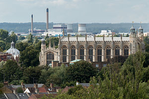
Eton College Chapel
Ancient chapel attached to Eton College
Distance: Approx. 368 meters
Latitude and longitude: 51.4916,-0.6087
Eton College Chapel is the main chapel of Eton College, a public school in England. The chapel was planned to be a little over double its actual length, but this plan was never completed owing to the downfall of the founder Henry VI. A plaque on a building opposite the west end marks the point to which it should have reached. The Chapel is built in the late Gothic or Perpendicular style.

St George's School, Windsor Castle
Independent coeducational preparatory school in Windsor, Berkshire, England
Distance: Approx. 391 meters
Latitude and longitude: 51.4855,-0.6056
St George's School, Windsor Castle is a co-educational private preparatory school in Windsor, near London, England. Founded to provide choirboys for the Choir of St George's Chapel, it now educates over 400 boys and girls.
Romney Island
Distance: Approx. 375 meters
Latitude and longitude: 51.4905,-0.6049
Romney Island is an island in the River Thames in England connected to Romney Lock, at Windsor, Berkshire. It is a long thin island with trees and scrub, with the upstream end in Windsor and the downstream end almost at Black Potts. The island has always been a popular place for angling and Isaak Walton used to fish from here.

Cutlers Ait
Distance: Approx. 237 meters
Latitude and longitude: 51.48944444,-0.60611111
Cutlers Ait is an island in the River Thames in England adjacent to Romney Island and Romney Lock, near Windsor, Berkshire. The island is a tree-covered strip adjacent to the opposite bank of the river from the Lock, near Eton. Romney weir sits between the two islands.

Firework Ait
Distance: Approx. 358 meters
Latitude and longitude: 51.4852,-0.6104
Firework Ait is an islet in the River Thames in England on the reach above Romney Lock known as the Windsor and Eton reach, Berkshire. It is the smallest island on the Thames with an official map-published name.
Eton Urban District
Distance: Approx. 26 meters
Latitude and longitude: 51.4881,-0.6092
The town of Eton formed a local government district in Buckinghamshire, England from 1849 to 1974. It was administered as a local board district from 1849 to 1894, and as an urban district from 1894 to 1974.

Eton Town Council Offices
Municipal building in Eton, Berkshire, England
Distance: Approx. 68 meters
Latitude and longitude: 51.4877,-0.6092
Eton Town Council Offices is a municipal building in the High Street in Eton, a town in Berkshire, in England. The building, which serves as the meeting place of Eton Town Council, is a locally listed building.
Weather in this IP's area
light rain
7 Celsius
4 Celsius
6 Celsius
9 Celsius
999 hPa
94 %
999 hPa
992 hPa
10000 meters
4.63 m/s
190 degree
75 %
