Country:
Region:
City:
Latitude and Longitude:
Time Zone:
Postal Code:
IP information under different IP Channel
ip-api
Country
Region
City
ASN
Time Zone
ISP
Blacklist
Proxy
Latitude
Longitude
Postal
Route
Luminati
Country
Region
co
City
longmont
ASN
Time Zone
America/Denver
ISP
COL-LPC
Latitude
Longitude
Postal
IPinfo
Country
Region
City
ASN
Time Zone
ISP
Blacklist
Proxy
Latitude
Longitude
Postal
Route
db-ip
Country
Region
City
ASN
Time Zone
ISP
Blacklist
Proxy
Latitude
Longitude
Postal
Route
ipdata
Country
Region
City
ASN
Time Zone
ISP
Blacklist
Proxy
Latitude
Longitude
Postal
Route
Popular places and events near this IP address

Prospect New Town
New Urbanist housing development in Colorado, USA
Distance: Approx. 5310 meters
Latitude and longitude: 40.135619,-105.105579
Prospect New Town is a New Urbanist housing development located on the southern edge of the city of Longmont in Boulder County, Colorado, in the United States. The first full-scale new urbanist new development in Colorado, it was developed starting in the mid-1990s by Kiki Wallace and designed by the firm of Duany Plater Zyberk & Company, who also designed the new urbanist communities of Seaside, Florida, and Kentlands in Gaithersburg, Maryland. As of 2009, the project is in its sixth phase of development.
Niwot High School
Public high school in Niwot, Colorado, United States
Distance: Approx. 5002 meters
Latitude and longitude: 40.10361111,-105.14444444
Niwot High School (NHS) is a public high school located in Niwot, Colorado. It is the International Baccalaureate high school of the St. Vrain Valley School District.
Olde Columbine High School
Public alternative high school in Longmont, Colorado, United States
Distance: Approx. 3933 meters
Latitude and longitude: 40.14619,-105.1205
Olde Columbine High School is an alternative high school in Longmont, Colorado, United States. The school is relatively small, having a student body of 80-100 students.

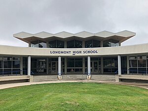
Longmont High School
Public high school in Longmont, Colorado, United States
Distance: Approx. 5276 meters
Latitude and longitude: 40.17638889,-105.12
Longmont High School is the original high school of the city of Longmont, Colorado, United States, and opened its doors to students in 1901. The school is located in central Longmont and serves as a high school for the St. Vrain Valley School District.

Silver Creek High School (Colorado)
Public high school in Longmont, Colorado, United States
Distance: Approx. 662 meters
Latitude and longitude: 40.15111111,-105.1675
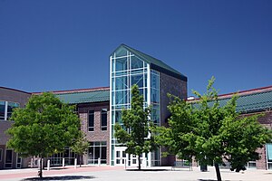
Silver Creek High School is a public high school located in Longmont, Colorado, United States. It is part of the St. Vrain Valley School District.

Hygiene, Colorado
Unincorporated community in Boulder County, Colorado
Distance: Approx. 4980 meters
Latitude and longitude: 40.18861111,-105.18083333
Hygiene is an unincorporated community with a U.S. Post Office in Boulder County, Colorado, United States. Application for the first Hygiene Post Office was made by Jacob Stoner Flory of the United Church of the Brethren on May 28, 1883. Originally named Pella, the community's present name stems from a time when it had a sanatorium to work with tuberculosis patients.
St. Vrain Valley School District
School district in Colorado, United States
Distance: Approx. 5186 meters
Latitude and longitude: 40.15535,-105.10722
The St. Vrain Valley School District is the local school district for Longmont, Colorado, United States, and several nearby communities. It is the seventh largest district in the state.

Left Hand Brewing Company
Brewery in Longmont, Colorado
Distance: Approx. 4605 meters
Latitude and longitude: 40.15849667,-105.11544556
Left Hand Brewing Company is a craft brewery located in Longmont, Colorado.

Ryssby Church
United States historic place
Distance: Approx. 3362 meters
Latitude and longitude: 40.13972222,-105.20555556
Ryssby Church is a church located outside of Longmont, Boulder County, Colorado. The church was built in 1882 by Swedish immigrants, although it fell into disuse between 1914 and 1924. A dedicated committee from the First Evangelical Lutheran Church, the descendant congregation of the Ryssby and Elim churches, maintains the church, organizes events, and funds continuous improvement projects.

St. Vrain Church of the Brethren
Historic church in Colorado, United States
Distance: Approx. 4835 meters
Latitude and longitude: 40.18861111,-105.16833333
The Church of the Brethren, also known as the St. Vrain Church of the Brethren and the Old Dunkard Church, is an historic Church of the Brethren meeting house located on Hygiene Road (17th Avenue) in Hygiene in the St. Vrain Valley of Boulder County, Colorado.

Vance Brand Airport
Airport
Distance: Approx. 2128 meters
Latitude and longitude: 40.16416667,-105.16361111
Vance Brand Airport (ICAO: KLMO, FAA LID: LMO, formerly AMR) is a city-owned public-use airport located three nautical miles (6 km) southwest of the central business district of Longmont, in Boulder County, Colorado, United States. The Airport is named after former NASA astronaut Vance Brand. Although many U.S. airports use the same three-letter location identifier for the FAA and IATA, this facility is assigned LMO by the FAA but has no designation from the IATA (which assigned LMO to RAF Lossiemouth in Lossiemouth, Scotland).

Hoverhome and Hover Farmstead
United States historic place
Distance: Approx. 5089 meters
Latitude and longitude: 40.18217,-105.13151
The Hoverhome and Hover Farmstead, at 1303-1309 Hover Rd. in Longmont, Colorado, are the remains of a historic farmstead. The current 4.3 acres (1.7 ha) site was listed on the National Register of Historic Places in 1999.
Weather in this IP's area
mist
1 Celsius
1 Celsius
-1 Celsius
2 Celsius
1027 hPa
93 %
1027 hPa
850 hPa
10000 meters
0.89 m/s
2.24 m/s
115 degree
100 %
06:38:44
16:50:15