161.97.209.128 - IP Lookup: Free IP Address Lookup, Postal Code Lookup, IP Location Lookup, IP ASN, Public IP
Country:
Region:
City:
Location:
Time Zone:
Postal Code:
IP information under different IP Channel
ip-api
Country
Region
City
ASN
Time Zone
ISP
Blacklist
Proxy
Latitude
Longitude
Postal
Route
Luminati
Country
Region
co
City
longmont
ASN
Time Zone
America/Denver
ISP
COL-LPC
Latitude
Longitude
Postal
IPinfo
Country
Region
City
ASN
Time Zone
ISP
Blacklist
Proxy
Latitude
Longitude
Postal
Route
IP2Location
161.97.209.128Country
Region
colorado
City
longmont
Time Zone
America/Denver
ISP
Language
User-Agent
Latitude
Longitude
Postal
db-ip
Country
Region
City
ASN
Time Zone
ISP
Blacklist
Proxy
Latitude
Longitude
Postal
Route
ipdata
Country
Region
City
ASN
Time Zone
ISP
Blacklist
Proxy
Latitude
Longitude
Postal
Route
Popular places and events near this IP address
Longmont, Colorado
City in Colorado, United States
Distance: Approx. 2418 meters
Latitude and longitude: 40.17166667,-105.10916667
Longmont is a home rule municipality located in Boulder and Weld counties, Colorado, United States. Its population was 98,885 as of the 2020 U.S. Census. Longmont is located northeast of the county seat of Boulder.
Olde Columbine High School
Public alternative high school in Longmont, Colorado, United States
Distance: Approx. 2563 meters
Latitude and longitude: 40.14619,-105.1205
Olde Columbine High School is an alternative high school in Longmont, Colorado, United States. The school is relatively small, having a student body of 80-100 students.

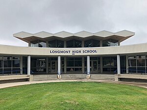
Longmont High School
Public high school in Longmont, Colorado, United States
Distance: Approx. 1840 meters
Latitude and longitude: 40.17638889,-105.12
Longmont High School is the original high school of the city of Longmont, Colorado, United States, and opened its doors to students in 1901. The school is located in central Longmont and serves as a high school for the St. Vrain Valley School District.
St. Vrain Valley School District
School district in Colorado, United States
Distance: Approx. 2745 meters
Latitude and longitude: 40.15535,-105.10722
The St. Vrain Valley School District is the local school district for Longmont, Colorado, United States, and several nearby communities. It is the seventh largest district in the state.

Left Hand Brewing Company
Brewery in Longmont, Colorado
Distance: Approx. 1962 meters
Latitude and longitude: 40.15849667,-105.11544556
Left Hand Brewing Company is a craft brewery located in Longmont, Colorado.

Vance Brand Airport
Airport
Distance: Approx. 2313 meters
Latitude and longitude: 40.16416667,-105.16361111
Vance Brand Airport (ICAO: KLMO, FAA LID: LMO, formerly AMR) is a city-owned public-use airport located three nautical miles (6 km) southwest of the central business district of Longmont, in Boulder County, Colorado, United States. The Airport is named after former NASA astronaut Vance Brand. Although many U.S. airports use the same three-letter location identifier for the FAA and IATA, this facility is assigned LMO by the FAA but has no designation from the IATA (which assigned LMO to RAF Lossiemouth in Lossiemouth, Scotland).
Denver Air Route Traffic Control Center
Distance: Approx. 2537 meters
Latitude and longitude: 40.1873,-105.127
Denver Air Route Traffic Control Center, (radio communications, Denver Center) is one of 22 American area control centers. It is located at 2211 17th Ave, Longmont, Colorado. The primary responsibility of Denver Center is sequencing and separation of over-flights, arrivals, and departures to provide safe, orderly, and expeditious flow of aircraft filed under instrument flight rules (IFR).

Longmont Fire Department Station 1
United States historic place
Distance: Approx. 2869 meters
Latitude and longitude: 40.16555556,-105.10277778
The Longmont Fire Department Station 1 is a former fire station in Longmont, Colorado, United States. Constructed in 1907, it remained in use as a fire station until 1971. The fire station is owned by the City of Longmont but is now leased to the Firehouse Art Center.

Longmont United Hospital
Hospital in Colorado, United States
Distance: Approx. 2025 meters
Latitude and longitude: 40.1821,-105.1262
Longmont United Hospital is an acute hospital in Longmont, Colorado, United States. The hospital has 186 beds. It includes a 24-hour emergency department.
Downtown Longmont Historic District
Historic district in Colorado, United States
Distance: Approx. 2892 meters
Latitude and longitude: 40.16583333,-105.1025
The Downtown Longmont Historic District, in Longmont, Colorado, is a historic district which was listed on the National Register of Historic Places in 2017. The district includes 83 buildings, 69 of which are deemed contributing buildings, and 17 of which were already designated Longmont Local Landmarks. Rehabilitation work on contributing buildings is eligible for tax credit funding; the local landmarks require a local Certificate of Appropriateness before exterior work, including signage and painting, can be done.

T. M. Callahan House
United States historic place
Distance: Approx. 2699 meters
Latitude and longitude: 40.1645,-105.10481
The T. M. Callahan House, also known as the ‘’’Sweeny-Callahan House’’’, at 312 Terry St. in Longmont, Colorado, is a large Queen Anne-style house built in 1892 and expanded in 1897 and 1908. It was listed on the National Register of Historic Places in 1985.

Hoverhome and Hover Farmstead
United States historic place
Distance: Approx. 1882 meters
Latitude and longitude: 40.18217,-105.13151
The Hoverhome and Hover Farmstead, at 1303-1309 Hover Rd. in Longmont, Colorado, are the remains of a historic farmstead. The current 4.3 acres (1.7 ha) site was listed on the National Register of Historic Places in 1999.
Weather in this IP's area
clear sky
15 Celsius
13 Celsius
13 Celsius
18 Celsius
1015 hPa
27 %
1015 hPa
842 hPa
10000 meters
4.12 m/s
340 degree

