Country:
 New Zealand
Region:
City:
Latitude and Longitude:
Time Zone:
Postal Code:
IP information under different IP Channel
ip-api
Country
Region
City
ASN
Time Zone
ISP
Blacklist
Proxy
Latitude
Longitude
Postal
Route
IPinfo
Country
Region
City
ASN
Time Zone
ISP
Blacklist
Proxy
Latitude
Longitude
Postal
Route
MaxMind
Country
Region
City
ASN
Time Zone
ISP
Blacklist
Proxy
Latitude
Longitude
Postal
Route
Luminati
Country
NZRegion
ota
City
dunedin
ASN
Time Zone
Pacific/Auckland
ISP
Two Degrees Networks Limited
Latitude
Longitude
Postal
db-ip
Country
Region
City
ASN
Time Zone
ISP
Blacklist
Proxy
Latitude
Longitude
Postal
Route
ipdata
Country
Region
City
ASN
Time Zone
ISP
Blacklist
Proxy
Latitude
Longitude
Postal
Route
Popular places and events near this IP address

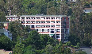
Salmond College
Distance: Approx. 2261 meters
Latitude and longitude: -45.854357,170.522372
Salmond College is a residential college affiliated to the University of Otago in Dunedin, New Zealand. As an affiliated college, it is privately owned and is run independently from the university, being governed by The Council of Knox College and Salmond College, a body with links to the Presbyterian Church of Aotearoa New Zealand. The college was opened in 1971 as Salmond Hall, originally to accommodate women students, to parallel the male-only facility Knox College.
Aquinas College, Otago
Distance: Approx. 1691 meters
Latitude and longitude: -45.850613,170.51727
Aquinas College is one of the Residential Colleges of the University of Otago, named after St. Thomas Aquinas, located in the suburb of Dalmore. Formerly a Roman Catholic institution in the care of the Dominican Order from the 1950s, the college was bought by the university in 1988 and was run for a time under the name Dalmore House, with the original name later restored.

John McGlashan College
School in Maori Hill, Dunedin, New Zealand
Distance: Approx. 2005 meters
Latitude and longitude: -45.8556,170.498
John McGlashan College is a state integrated boarding and day school for boys, located in the suburb of Maori Hill in Dunedin, New Zealand. The school currently caters for 532 students from years 7 to 13, including 120 boarders and up to 30 international students. The school is named after John McGlashan, a significant Presbyterian lawyer, politician, public servant and educationalist, and was founded after his daughters' gift of the family home and estate in 1918 on the provision that a Presbyterian school was established for boys.
Pine Hill, New Zealand
Suburb of Dunedin, New Zealand
Distance: Approx. 1209 meters
Latitude and longitude: -45.8414,170.5196
Pine Hill is a suburb, hill, and general area of the New Zealand city of Dunedin. It is sited on the hill of the same name, a spur of Mount Cargill overlooking North East Valley and Glenleith 4 kilometres (2.5 mi) to the north of the city centre. This spur lies in the fork of the confluence of the Water of Leith and its largest tributary, the Lindsay Creek.

North East Valley
Suburb in Dunedin, New Zealand
Distance: Approx. 2125 meters
Latitude and longitude: -45.853,170.522
North East Valley (sometimes spelled Northeast Valley, and often abbreviated to NEV) is a suburb of the New Zealand city of Dunedin.

Maori Hill
Suburb of Dunedin, New Zealand
Distance: Approx. 2285 meters
Latitude and longitude: -45.8585,170.5003
Māori Hill is a residential suburb of the New Zealand city of Dunedin. It is located at the northern end of the ridge which runs in a crescent around the central city's western edge, 2 kilometres (1.2 mi) to the northwest of the city centre, immediately above and within the Town Belt. It is connected to Dunedin North, which lies to the east, via Drivers Road, the suburbs of Roslyn and Kaikorai to the southwest via Highgate, and the suburb of Wakari to the northwest via Balmacewen Road.
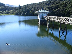
Ross Creek Reservoir
Reservoir in Dunedin, New Zealand
Distance: Approx. 1098 meters
Latitude and longitude: -45.8471,170.4986
The Ross Creek Reservoir is an artificial lake in Dunedin, New Zealand. One of the oldest artificial lakes in the country, and the oldest water supply reservoir still in use in the country, it was created in the 1860s to provide water for the city of Dunedin, at that time in the middle of rapid expansion due to the Otago gold rush. Designed by engineer Ralph Donkin and supervising builder David Proudfoot, the reservoir was opened in 1867 as the Royal Albert Reservoir, but the name was unpopular and it has been known as the Ross Creek Reservoir for over a century.
Helensburgh, New Zealand
Suburb in Dunedin, New Zealand
Distance: Approx. 2387 meters
Latitude and longitude: -45.851,170.48
Helensburgh is a suburb of the New Zealand city of Dunedin. It is located to the northwest of the city centre. Helensburgh is located immediately to the north of Wakari and east of Halfway Bush.
Leith Valley
Suburb in Dunedin, New Zealand
Distance: Approx. 781 meters
Latitude and longitude: -45.8451,170.5065
Leith Valley is a suburb, valley, and general area of the New Zealand city of Dunedin, located to the northwest of the city centre. To differentiate the name of the valley from that of the suburb, the former is usually referred to as the Leith Valley, the latter simply as Leith Valley.

Caroline Freeman College
Residential college owned and operated by the University of Otago in Dunedin
Distance: Approx. 2452 meters
Latitude and longitude: -45.85896944,170.51523889
Caroline Freeman College is a residential college owned and operated by the University of Otago in Dunedin, New Zealand. The college is located a short distance north of the Otago central campus near the Dunedin Botanical Gardens.

Moore's Bush Reserve
Distance: Approx. 2186 meters
Latitude and longitude: -45.81910278,170.51123611
Moore's Bush Reserve, also known as Moore's Bush, is a small reserve in the suburb of Leith Valley in Dunedin, New Zealand. This 4-hectare reserve is a combination of remnant native forest and a former dairy farm that has been replanted with native species. A number of small streams, including the Leith, run through the reserve.
Dalmore Reserve
Reserve and community garden in Dunedin, New Zealand
Distance: Approx. 1649 meters
Latitude and longitude: -45.84972222,170.51805556
Dalmore Reserve is a small reserve in the suburb of Dalmore in Dunedin. It is managed by Dunedin City Council who purchased the land in 1990 from the Dominican Order. The 6-hectare reserve is primarily lowland native forest and features a community garden and walking tracks.
Weather in this IP's area
overcast clouds
9 Celsius
9 Celsius
9 Celsius
9 Celsius
999 hPa
98 %
999 hPa
977 hPa
10000 meters
1.79 m/s
5.81 m/s
60 degree
100 %
06:56:19
19:54:32