Country:
 New Zealand
Region:
City:
Latitude and Longitude:
Time Zone:
Postal Code:
IP information under different IP Channel
ip-api
Country
Region
City
ASN
Time Zone
ISP
Blacklist
Proxy
Latitude
Longitude
Postal
Route
IPinfo
Country
Region
City
ASN
Time Zone
ISP
Blacklist
Proxy
Latitude
Longitude
Postal
Route
MaxMind
Country
Region
City
ASN
Time Zone
ISP
Blacklist
Proxy
Latitude
Longitude
Postal
Route
Luminati
Country
NZASN
Time Zone
Pacific/Auckland
ISP
Two Degrees Networks Limited
Latitude
Longitude
Postal
db-ip
Country
Region
City
ASN
Time Zone
ISP
Blacklist
Proxy
Latitude
Longitude
Postal
Route
ipdata
Country
Region
City
ASN
Time Zone
ISP
Blacklist
Proxy
Latitude
Longitude
Postal
Route
Popular places and events near this IP address
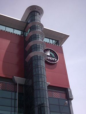
SkyCity Auckland
Entertainment complex and casino in Auckland, New Zealand
Distance: Approx. 426 meters
Latitude and longitude: -36.8488,174.7617
Skycity Auckland is an entertainment complex and casino in the central business district of Auckland, New Zealand, between Victoria and Federal Streets. Located at the base of the Sky Tower, it was the second casino in New Zealand, and is the only casino in Auckland.

St Matthew's, Auckland
Historic church in Auckland, New Zealand
Distance: Approx. 373 meters
Latitude and longitude: -36.8502,174.7611
St Matthew's-in-the-City Church, sometimes abbreviated as St Matthew's, or commonly known as St Matthew-in-the-City, is an historic Anglican church located at 132-134 Hobson Street in the central business district of Auckland, in the North Island of New Zealand. Part of the Anglican Church in Aotearoa, New Zealand and Polynesia and the Diocese of Auckland, the church was completed in 1905 and is renowned for its Gothic Revival style.
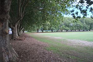
Victoria Park, Auckland
Distance: Approx. 352 meters
Latitude and longitude: -36.8469,174.75475
Victoria Park is a park and sports ground in the Auckland city centre, New Zealand. It was opened in 1905 and named after the queen who had died four years earlier. It lies on reclaimed bay land in Freemans Bay, a suburb directly west of the Auckland CBD. However, it does not have direct connection to the foreshore anymore, as the Western Reclamation and the Viaduct Basin quarter lie between it and the Waitematā Harbour.

Victoria Park Market
Retail complex in Auckland, New Zealand
Distance: Approx. 289 meters
Latitude and longitude: -36.8485,174.754
Victoria Park Market is a cluster of galleries, workshops, studios, offices, restaurants and retail shops as well as a gym and Pilates Studio in Auckland, New Zealand. The precinct is housed in a former waste depot and incinerator complex. It is located in Freemans Bay and its name derives from the adjacent Victoria Park which was created in 1905 and named after the late Queen who had died four years earlier.

Victoria Park Viaduct
Major motorway viaduct in Auckland, New Zealand
Distance: Approx. 454 meters
Latitude and longitude: -36.846839,174.753136
The Victoria Park Viaduct is a major motorway viaduct carrying the Auckland Northern Motorway (State Highway 1) over the Victoria Park area in the Auckland city centre, New Zealand. Construction began in 1959, and the bridge was opened on 5 April 1962. Due to the high traffic volumes passing through on their way to and from North Shore City, and because the viaduct is only four lanes wide in total (while adjacent motorway stretches are at least six lanes), the bridge over the park is considered "one of the country's worst traffic bottlenecks", with around 200,000 vehicles a day.
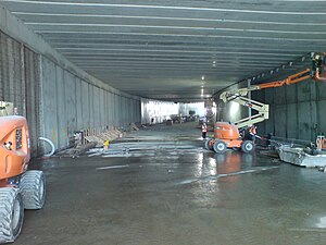
Victoria Park Tunnel
Vehicle tunnel in Auckland, New Zealand
Distance: Approx. 442 meters
Latitude and longitude: -36.847045,174.753095
The Victoria Park Tunnel is a motorway tunnel completed in 2012 on New Zealand State Highway 1 in Auckland, New Zealand, taking northbound traffic off the Victoria Park Viaduct, which was converted to all southbound traffic. It lies mostly under Victoria Park.
Big 106.2
Radio station in Auckland, New Zealand
Distance: Approx. 471 meters
Latitude and longitude: -36.8484,174.7621
Big 106.2 or Big FM was a radio station in Auckland, New Zealand, that was launched on 1 November 2008 at 9AM, broadcasting on 106.2FM. The original station was started by radio veterans Larry Summerville and Bernie Brown and was owned and operated by Big Radio Limited. The original station played Adult Contemporary music. In April 2010 there were reports that Big FM had been sold to Thane and Richard Kirby for an undisclosed sum.

Grafton United Cricket Club
New Zealand cricket club
Distance: Approx. 417 meters
Latitude and longitude: -36.846129,174.754965
Grafton United Cricket Club is one of New Zealand's oldest and largest cricket clubs, catering for around 700 senior members and 600 juniors (as of October 2017) from its clubrooms at Victoria Park, in central Auckland. The club was founded as the United Cricket Club, on 18 September 1862 by players from existing Auckland clubs and was often referred to as 'the United' because of this. The club aimed to acquire more regular and more challenging competition than that which was on offer in Auckland at the time.
Music and Audio Institute of New Zealand
Distance: Approx. 271 meters
Latitude and longitude: -36.848,174.7594
Music and Audio Institute of New Zealand (MAINZ) is a faculty of the Southern Institute of Technology, focused on contemporary music and music-industry related education. MAINZ offers music and audio courses from Diplomas to Certificates at its campus in Christchurch. MAINZ alumni include Joel Little, Josh Fountain, Troy Kingi, Karen Hunter, Gin Wigmore, Zowie, members of the Checks, Concord Dawn, Goldenhorse, Goodnight Nurse, Midnight Youth, the Mint Chicks, The Naked and Famous and 8 Foot Sativa.

ZM Auckland
Radio station
Distance: Approx. 471 meters
Latitude and longitude: -36.8484,174.7621
ZM Auckland is a hit music radio station in Auckland, New Zealand. The station is the host of the ZM network, and is owned and operated by New Zealand Media and Entertainment. Several stations have been set up since 2002 to carry ZM programmes from Auckland with local advertisements – ZM Gisborne in 2002, ZM Wanganui in 2004, ZM South Canterbury in September 2004, ZM Blenheim in January 2007, ZM Wairarapa in 2010, ZM Taupo in 2013, ZM Queenstown in 2014, ZM Wanaka in May 2016, ZM West Coast in July 2020 and ZM Coromandel in December 2021.

New Zealand International Convention Centre fire
Distance: Approx. 297 meters
Latitude and longitude: -36.8491,174.7603
On Tuesday, 22 October 2019, a fire broke out on the roof of the New Zealand International Convention Centre in Auckland, New Zealand. The convention centre is to become part of the SkyCity complex and was undergoing construction by Fletcher Construction, due for completion before the end of the year. The site was occupied by construction workers at the time and was not open to the public.

Hobson Street, Auckland
Distance: Approx. 361 meters
Latitude and longitude: -36.85,174.761
Hobson Street is the major street in Auckland, New Zealand. It lies on the western side of Queen Street. It is a commercial and high-rise residential street, and provides access to the Auckland Northern Motorway going south, and the Northwest Motorway going west.
Weather in this IP's area
few clouds
11 Celsius
10 Celsius
10 Celsius
12 Celsius
996 hPa
70 %
996 hPa
990 hPa
10000 meters
5.14 m/s
290 degree
20 %
06:18:17
18:12:56