Country:
 New Zealand
Region:
City:
Latitude and Longitude:
Time Zone:
Postal Code:
IP information under different IP Channel
ip-api
Country
Region
City
ASN
Time Zone
ISP
Blacklist
Proxy
Latitude
Longitude
Postal
Route
IPinfo
Country
Region
City
ASN
Time Zone
ISP
Blacklist
Proxy
Latitude
Longitude
Postal
Route
MaxMind
Country
Region
City
ASN
Time Zone
ISP
Blacklist
Proxy
Latitude
Longitude
Postal
Route
Luminati
Country
NZRegion
can
City
christchurch
ASN
Time Zone
Pacific/Auckland
ISP
Sky Network Television Ltd
Latitude
Longitude
Postal
db-ip
Country
Region
City
ASN
Time Zone
ISP
Blacklist
Proxy
Latitude
Longitude
Postal
Route
ipdata
Country
Region
City
ASN
Time Zone
ISP
Blacklist
Proxy
Latitude
Longitude
Postal
Route
Popular places and events near this IP address

Belfast, New Zealand
Suburb of Christchurch, New Zealand
Distance: Approx. 1673 meters
Latitude and longitude: -43.45,172.63333333
Belfast (Māori: Purarekanui) is a suburb of Christchurch, New Zealand. It is in the north of the city 10 km (6.2 mi) from Cathedral Square, close to the banks of the Waimakariri River.

Redwood, Christchurch
Suburb of Christchurch, New Zealand
Distance: Approx. 4274 meters
Latitude and longitude: -43.4766,172.61696
Redwood is a northern suburb of Christchurch, New Zealand which includes the sub-division of Redwood Springs. It is bordered by the Styx River to the north. Before the area was settled the original forest cover was tōtara and kahikatea.

St Bede's College, Christchurch
School
Distance: Approx. 4769 meters
Latitude and longitude: -43.48333333,172.61833333
St. Bede's College is an integrated Roman Catholic day and boarding school in Christchurch, New Zealand, for boys aged 12 (Year 9) to 18 (Year 13). St.

Bottle Lake Forest
Forest near Christchurch, New Zealand
Distance: Approx. 3332 meters
Latitude and longitude: -43.4524,172.695
Bottle Lake Forest is a production forest and recreational park located in Christchurch, New Zealand, approximately 10 kilometres (6.2 mi) north-east of the city centre. It makes up the vast majority of the area of the suburb Bottle Lake. The visitor centre at the Forest's entry from Waitikiri Drive provides visitors with information about the different roles of Bottle Lake Forest.

Spencerville, New Zealand
Suburb of Christchurch, New Zealand
Distance: Approx. 3983 meters
Latitude and longitude: -43.432042,172.69725
Spencerville is a semi-rural town on the east coast of Canterbury, New Zealand north of Christchurch. The town backs on to Bottle Lake Forest and includes a large (1 hectare) park and 80 hectare camping ground. These amenities, as well as wetlands and an animal and bird park make the town a popular camping area for Christchurch residents.
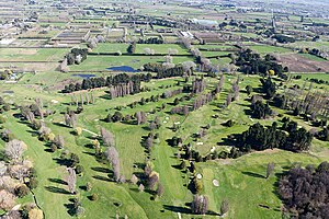
The Clearwater Resort
Golf course in Christchurch, New Zealand
Distance: Approx. 4626 meters
Latitude and longitude: -43.4464,172.5969
The Clearwater Golf Club at Clearwater Resort in Christchurch is a par-72 championship course that was most recently the home to the ISPS Handa NZ Women's Open from 2013 to 2016. It was also the former home to both the BMW New Zealand Open and the New Zealand PGA Championship that was staged on the Nationwide Tour. Designed by John Darby in consultation with New Zealand golfing legend, Sir Bob Charles, the course combines elements of links golf inspired by the great Scottish courses with parkland golf, more reminiscent of Florida.

Bottle Lake, New Zealand
Rural area in Christchurch, New Zealand
Distance: Approx. 1164 meters
Latitude and longitude: -43.455,172.666
Bottle Lake is an area in the north-east of Christchurch with a low number of residents. Most of the area is covered by Bottle Lake Forest, which has since the mid-1970s become a popular recreation area. The area was known as Waitikiri to Māori and the swamplands around a lake was a traditional mahinga kai (food gathering place).

Kainga, New Zealand
Settlement in Canterbury, New Zealand
Distance: Approx. 4326 meters
Latitude and longitude: -43.41083333,172.6625
Kainga is a settlement on the southern bank of the Waimakariri River, just north of Christchurch, in Canterbury, New Zealand. It lies immediately to the south of Kaiapoi, on a small road leading northeast from State Highway 1. Originally established as a small group of fishing huts on the south side of the Waimakariri, it later developed into a small residential area.
Northwood, New Zealand
Suburb of Christchurch, New Zealand
Distance: Approx. 3224 meters
Latitude and longitude: -43.458,172.616
Northwood is a suburb on the northern outskirts of Christchurch city. It was developed in 2000 as a subdivision of Belfast on land previously used for apple orchards. The name "Northwood" was accepted at a meeting of the Shirley-Papanui Community Board on 2 February 2000.
Casebrook
Suburb of Christchurch, New Zealand
Distance: Approx. 4762 meters
Latitude and longitude: -43.475,172.607
Casebrook is a suburb on the northern side of Christchurch city. The land was farmed by Walter Case (1881?–1961). When Casebrook Intermediate was built in 1966, it combined his name with the presence of a stream near the school.
Marshland, New Zealand
Suburb of Christchurch, New Zealand
Distance: Approx. 2877 meters
Latitude and longitude: -43.475,172.652
Marshland is a semi-rural suburb on the northern side of Christchurch city. The land is primarily used for horticulture and dairy farming. The suburb is named for the peaty soil, and was also called Rhodes' Swamp after landowner and politician Robert Heaton Rhodes (1815–1884).
Prestons, New Zealand
Suburb of Christchurch, New Zealand
Distance: Approx. 3015 meters
Latitude and longitude: -43.474,172.669
Prestons is a suburb on the northeastern side of Christchurch city. The suburb is named for Thomas Herbert Preston (1824–1884), a local resident and chair of the Avon Road Board. It was first planned as a residential suburb in 2007, and constructed in the 2010s.
Weather in this IP's area
broken clouds
17 Celsius
17 Celsius
17 Celsius
18 Celsius
1003 hPa
60 %
1003 hPa
1002 hPa
10000 meters
5.95 m/s
8.85 m/s
341 degree
77 %
06:49:53
19:43:47