161.30.155.194 - IP Lookup: Free IP Address Lookup, Postal Code Lookup, IP Location Lookup, IP ASN, Public IP
Country:
Region:
City:
Location:
Time Zone:
Postal Code:
IP information under different IP Channel
ip-api
Country
Region
City
ASN
Time Zone
ISP
Blacklist
Proxy
Latitude
Longitude
Postal
Route
Luminati
Country
ASN
Time Zone
Europe/London
ISP
Inmarsat Global Limited
Latitude
Longitude
Postal
IPinfo
Country
Region
City
ASN
Time Zone
ISP
Blacklist
Proxy
Latitude
Longitude
Postal
Route
IP2Location
161.30.155.194Country
Region
england
City
shrewsbury
Time Zone
Europe/London
ISP
Language
User-Agent
Latitude
Longitude
Postal
db-ip
Country
Region
City
ASN
Time Zone
ISP
Blacklist
Proxy
Latitude
Longitude
Postal
Route
ipdata
Country
Region
City
ASN
Time Zone
ISP
Blacklist
Proxy
Latitude
Longitude
Postal
Route
Popular places and events near this IP address
Shrewsbury Castle
Historic site
Distance: Approx. 212 meters
Latitude and longitude: 52.71111111,-2.74944444
Shrewsbury Castle is a red sandstone castle in Shrewsbury, Shropshire, England. It stands on a hill in the neck of the meander of the River Severn on which the town originally developed. The castle, directly above Shrewsbury railway station, is a Grade I listed building.

Roman Catholic Diocese of Shrewsbury
Catholic diocese in England
Distance: Approx. 267 meters
Latitude and longitude: 52.708,-2.754
The Diocese of Shrewsbury (Latin: Dioecesis Salopiensis) is a Latin Church diocese of the Catholic Church in the Province of Birmingham which encompasses the pre-1974 counties of Shropshire and Cheshire in the North West and West Midlands of England. The diocese includes rural areas of Shropshire as well as Manchester south of the River Mersey and other urban areas such as Birkenhead, Stockport and Ellesmere Port. The current bishop, Mark Davies, succeeded on 1 October 2010.
Shrewsbury railway station
Grade II listed railway station in Shropshire, England
Distance: Approx. 255 meters
Latitude and longitude: 52.712,-2.75
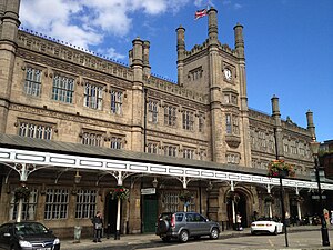
Shrewsbury railway station serves the town of Shrewsbury, in Shropshire, England. Built in 1848, it was designated a grade II listed building in 1969. Many services starting at or passing through the station are bound for Wales, and it is a key hub for its operator, Transport for Wales; services are also provided by West Midlands Railway.
New Riverside, Shrewsbury
Distance: Approx. 159 meters
Latitude and longitude: 52.70916667,-2.75388889
New Riverside is a proposed £150m shopping centre redevelopment project in Shrewsbury, Shropshire, England, which is planned to link the town's Darwin and former Pride Hill centres and comprehensively redevelop the Riverside centre site. The redevelopment will comprise approximately 50 new shops and 15 new restaurant and cafe units, totalling around 225,000 sq ft and create one, linked and extended centre of 680,000 sq ft. Preliminary plans were put to public consultation in July 2011 and the scheme was granted planning permission in April 2012.
Shropshire Archives
Distance: Approx. 87 meters
Latitude and longitude: 52.71083333,-2.75166667
Shropshire Archives is located in Shrewsbury, England, and is the archives and local studies service for the historic county of Shropshire, which includes the borough of Telford and Wrekin. It preserves and makes accessible documents, books, maps, photographs, plans and drawings relating to Shropshire and its people dating from the early 12th to the 21st century. Shropshire Archives is funded by Shropshire Council and Telford and Wrekin Borough Council and is supported by an active friends organisation - the Friends of Shropshire Archives.
Darwin Shopping Centre
Shopping mall in Shrewsbury, England
Distance: Approx. 17 meters
Latitude and longitude: 52.7102,-2.7523
The Darwin Shopping Centre (currently promoted as The Darwin) is the main shopping centre in Shrewsbury, Shropshire, England, comprising approximately 17 per cent of the town centre's retail offer by leasable area. It was built by John Laing Developments in 1989 and refurbished in 2002. It was in 2010 due to undergo further refurbishment in a plan being devised by Chapman Taylor Architects as part of the New Riverside redevelopment.

Shrewsbury Library
Distance: Approx. 99 meters
Latitude and longitude: 52.71055556,-2.75083333
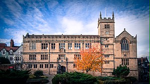
Shrewsbury Library is housed in a Grade I listed building situated on Castle Gates near Shrewsbury Castle. The site was the home of Shrewsbury School from 1550 until 1882. The buildings were handed over to the town in 1882 and a free library and museum were opened by the Corporation of Shrewsbury utilizing the building in 1885.

Shrewsbury Hoard
Hoard of Roman coins found in England
Distance: Approx. 142 meters
Latitude and longitude: 52.71,-2.75
The Shrewsbury Hoard (also known as the Shropshire Hoard) is a hoard of 9,315 bronze Roman coins discovered by a metal detectorist in a field near Shrewsbury, Shropshire in August 2009. The coins were found in a large pottery storage jar that was buried in about AD 335.

St Mary's Church, Shrewsbury
Church in Shropshire, England
Distance: Approx. 165 meters
Latitude and longitude: 52.7087,-2.7513
St Mary's Church is a redundant Anglican church in St Mary's Place, Shrewsbury, Shropshire, England. It is recorded in the National Heritage List for England as a designated Grade I listed building, and is under the care of the Churches Conservation Trust, the Trust designated St Mary's as its first Conservation Church in 2015. It is the largest church in Shrewsbury.

The Parade Shopping Centre
Historic site in Shrewsbury, Shropshire, England
Distance: Approx. 202 meters
Latitude and longitude: 52.7085,-2.7507
The Parade Shops, formerly the Royal Salop Infirmary, is a specialist shopping centre at St Mary's Place in Shrewsbury, Shropshire, England. It is a Grade II listed building.

Kingston House, Shrewsbury
Historic site in Shropshire, England
Distance: Approx. 225 meters
Latitude and longitude: 52.7081,-2.7526
Kingston House is a building in St Alkmund's Place, Shrewsbury. It is a Grade II listed building.
Shrewsbury bus station
Transport hub in Shrewsbury, England
Distance: Approx. 142 meters
Latitude and longitude: 52.71,-2.75
Shrewsbury bus station is a bus station and terminus located on Raven Meadows in the centre of Shrewsbury, the county town of Shropshire, England. Local and inter-city services, predominantly operated by Arriva Midlands North, run from the station. Additional services are operated by Lakeside Coaches, Tanat Valley, Celtic Travel and Minsterley Motors.
Weather in this IP's area
sleet
0 Celsius
-5 Celsius
0 Celsius
1 Celsius
993 hPa
96 %
993 hPa
979 hPa
5000 meters
6.17 m/s
100 degree
100 %


