Country:
 New Zealand
Region:
City:
Latitude and Longitude:
Time Zone:
Postal Code:
IP information under different IP Channel
ip-api
Country
Region
City
ASN
Time Zone
ISP
Blacklist
Proxy
Latitude
Longitude
Postal
Route
IPinfo
Country
Region
City
ASN
Time Zone
ISP
Blacklist
Proxy
Latitude
Longitude
Postal
Route
MaxMind
Country
Region
City
ASN
Time Zone
ISP
Blacklist
Proxy
Latitude
Longitude
Postal
Route
Luminati
Country
NZASN
Time Zone
Pacific/Auckland
ISP
Two Degrees Networks Limited
Latitude
Longitude
Postal
db-ip
Country
Region
City
ASN
Time Zone
ISP
Blacklist
Proxy
Latitude
Longitude
Postal
Route
ipdata
Country
Region
City
ASN
Time Zone
ISP
Blacklist
Proxy
Latitude
Longitude
Postal
Route
Popular places and events near this IP address

Balloons over Waikato
Distance: Approx. 308 meters
Latitude and longitude: -37.79906,175.26847
Balloons over Waikato is an annual hot air balloon festival held in Hamilton, New Zealand since 1999 by the non-profit organisation Balloons over Waikato Trust. The event spans five days during autumn and attracts both local and overseas balloonists. The Festival is held primarily at Innes Common, at Hamilton Lake, which gets an estimated 130,000 visitors during the festival.
Hamilton Girls' High School
New Zealand girls' high school
Distance: Approx. 1045 meters
Latitude and longitude: -37.7896,175.277
Hamilton Girls' High School (Māori: Te Kura Tamaahine o Kirikiriroa) is a state single sex secondary school located in central Hamilton, New Zealand. The school caters for students in Years 9 to 13 (ages 12 to 18).
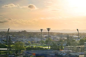
Seddon Park
New Zealand Cricket ground
Distance: Approx. 1280 meters
Latitude and longitude: -37.78666667,175.27416667
Seddon Park is a cricket ground in Hamilton, New Zealand. It is the fourth-largest cricket ground in the country, and is renowned for its "village green" setting, affording a picnic atmosphere for spectators.

Waikato Hospital
Hospital in Waikato, New Zealand
Distance: Approx. 1167 meters
Latitude and longitude: -37.80430833,175.28229444
Waikato Hospital is a major regional hospital in Hamilton, New Zealand. It provides specialised and emergency healthcare for the Midlands and Waikato area with patients referred there from feeder hospitals like Whakatāne, Lakes area, Tauranga, Thames, Tokoroa and Rotorua.
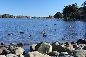
Lake Rotoroa (Hamilton)
Lake in the North Island of New Zealand
Distance: Approx. 231 meters
Latitude and longitude: -37.799,175.274
Lake Rotoroa or Hamilton Lake (officially Lake Rotoroa / Hamilton Lake) is a lake in Hamilton, Waikato, North Island, New Zealand. It has a surface area of about 54 hectares (133 acres) and an average depth of 2.4 metres (7 ft 10 in). It is the home of the Hamilton Yacht Club, which holds regular sailing in the summer.
Hamilton West, New Zealand
Suburb of Hamilton, New Zealand
Distance: Approx. 1050 meters
Latitude and longitude: -37.796425,175.283475
Hamilton West is a suburb in western Hamilton in New Zealand. Hamilton Lake (a.k.a. Lake Rotoroa) is located to the west.
Braemar Hospital
Hospital in Waikato, New Zealand
Distance: Approx. 1286 meters
Latitude and longitude: -37.80781667,175.27939722
Braemar Hospital is one of the New Zealand's largest private hospitals. It is owned by the Braemar Charitable Trust located in Hamilton, New Zealand. There was a separate and unrelated organisation, Braemar Hospital in Nelson, New Zealand which provided long term psychiatric care for children.

Hamilton Urban Area
Urban area in North Island, New Zealand
Distance: Approx. 1355 meters
Latitude and longitude: -37.7882,175.28083611
The Hamilton Urban Area is a New Zealand urban area in the Waikato region. It is the fourth-largest urban area in the country with a population of 241,200. At its centre is Hamilton City, New Zealand's fourth-largest territorial authority.
Hamilton City Council (New Zealand)
Distance: Approx. 1239 meters
Latitude and longitude: -37.7882762,175.2785522
Hamilton City Council (Māori: Te kaunihera o Kirikiriroa) is the territorial authority for the New Zealand city of Hamilton. The council is led by the mayor of Hamilton, who is currently Paula Southgate. There are also 14 ward councillors.
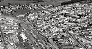
Hamilton railway station, New Zealand
Railway station in New Zealand
Distance: Approx. 904 meters
Latitude and longitude: -37.791611,175.26536
Hamilton railway station serves the city of Hamilton in the Waikato region of New Zealand. It is located in the suburb of Frankton, hence the station's former name Frankton Junction, its name for most of its existence. The station is a Keilbahnhof, located at the junction of the North Island Main Trunk (NIMT) and East Coast Main Trunk (ECMT) lines.

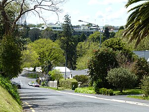
Hamilton Lake (suburb)
Suburb of Hamilton, New Zealand
Distance: Approx. 815 meters
Latitude and longitude: -37.804,175.277
Hamilton Lake is a residential suburb of Hamilton, surrounding Lake Rotoroa and the Hamilton Lake Domain. Most of the housing in the suburb was built in the 1970s. The roads close to the lake are considered to be amongst Hamilton's premium streets.
Gower Park
Distance: Approx. 1038 meters
Latitude and longitude: -37.807315,175.272144
Gower Park, is a multi-purpose stadium in the Hamilton, New Zealand, suburb of Melville. It is used for football matches and is the home stadium of New Zealand National League and Northern League side Melville United.
Weather in this IP's area
light rain
10 Celsius
8 Celsius
9 Celsius
10 Celsius
994 hPa
86 %
994 hPa
989 hPa
9457 meters
3.76 m/s
9.27 m/s
279 degree
65 %
06:16:27
18:10:43