Country:
 New Zealand
Region:
City:
Latitude and Longitude:
Time Zone:
Postal Code:
IP information under different IP Channel
ip-api
Country
Region
City
ASN
Time Zone
ISP
Blacklist
Proxy
Latitude
Longitude
Postal
Route
IPinfo
Country
Region
City
ASN
Time Zone
ISP
Blacklist
Proxy
Latitude
Longitude
Postal
Route
MaxMind
Country
Region
City
ASN
Time Zone
ISP
Blacklist
Proxy
Latitude
Longitude
Postal
Route
Luminati
Country
NZASN
Time Zone
Pacific/Auckland
ISP
Two Degrees Networks Limited
Latitude
Longitude
Postal
db-ip
Country
Region
City
ASN
Time Zone
ISP
Blacklist
Proxy
Latitude
Longitude
Postal
Route
ipdata
Country
Region
City
ASN
Time Zone
ISP
Blacklist
Proxy
Latitude
Longitude
Postal
Route
Popular places and events near this IP address

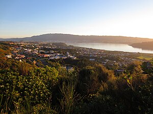
Plimmerton
Suburb of Porirua
Distance: Approx. 28 meters
Latitude and longitude: -41.08333333,174.86666667
The suburb of Plimmerton lies in the northwest part of the city of Porirua in New Zealand, adjacent to some of the city's more congenial beaches. State Highway 59 and the North Island Main Trunk railway line pass just east of the main shopping and residential area. Plimmerton has its modern origins as a late 19th century seaside resort.

Camborne, New Zealand
Suburb of Porirua
Distance: Approx. 899 meters
Latitude and longitude: -41.089683,174.873573
Camborne, New Zealand is a hilltop and seaside suburb of Porirua. Camborne covers an area of 0.84 km², including a land area of 0.84 km². Most of the suburb is a short walk from Porirua Harbour, and many homes have views of the harbour, neighbouring hills, the sea and Mana Island.

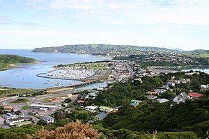
Porirua Harbour
Harbour in New Zealand
Distance: Approx. 1426 meters
Latitude and longitude: -41.08333333,174.85
Te Awarua-o-Porirua Harbour, commonly known as Porirua Harbour, is a natural inlet in the south-western coast of the North Island of New Zealand. The harbour is within the main urban area of the Wellington Region, and is surrounded by the city of Porirua, with the city centre to the south of the harbour.

Fort Parramatta
Distance: Approx. 1745 meters
Latitude and longitude: -41.09896389,174.86635278
Fort Parramatta was the name given to a fort north of Wellington, New Zealand, in the 1840s. It was built 1846-47. The earthquakes of 1848 and 1855 reduced the building to a ruinous condition.
Papakōwhai
Suburb of Porirua
Distance: Approx. 3307 meters
Latitude and longitude: -41.113,174.868
Papakōwhai is a suburb of Porirua City. It lies approximately 22 kilometres (14 mi) north of Wellington in New Zealand. The name "Papakōwhai" (Māori pronunciation: [papaˈkɔfai]) in the Māori language means "yellow earth".

Titahi Bay Transmitter
Distance: Approx. 2483 meters
Latitude and longitude: -41.09611111,174.84277778
The Titahi Bay Transmitter, which until 16 February 2016 was New Zealand's second tallest structure, transmitted AM radio signals from a 220 metres tall radio mast insulated against ground at Titahi Bay in New Zealand. The station which previously had three masts, now consists of only one mast with a height of 137 metres. A third – smaller – mast with a height of 53 metres was toppled on 10 November 2015.
Mana, New Zealand
Suburb in Porirua, New Zealand
Distance: Approx. 1599 meters
Latitude and longitude: -41.097548,174.869463
Mana is a locality of Porirua City in New Zealand, part of the Suburb of Paremata. It is a narrow isthmus bounded to the west by the entrance to Porirua Harbour, and to the east by the Pauatahanui inlet of the Porirua Harbour. Mana Island lies about three kilometres west of the isthmus.

Karehana Bay
Bay and nearby residential area at the western end of Plimmerton, New Zealand
Distance: Approx. 2337 meters
Latitude and longitude: -41.06666667,174.85
Karehana Bay is a bay and nearby residential area at the western end of Plimmerton, a northern coastal locality of Porirua. It is located near the entrance to the Porirua Harbour, to the south-east of Hongoeka. It is about 5 minutes drive to Karehana Bay from the State Highway 59 turnoff to Plimmerton.

Taupō Swamp
Swamp in New Zealand
Distance: Approx. 28 meters
Latitude and longitude: -41.08333333,174.86666667
Taupō Swamp is a lowland freshwater swamp located three kilometres (1.9 mi) north of Plimmerton and 20 kilometres (12 mi) north-northeast of Wellington. In 1986 the Queen Elizabeth II National Trust purchased Taupō Swamp with the aim of both protecting and restoring the wetland. Taupō Swamp is home to largely indigenous vegetation including sedges, flax, ferns, shrubs, herbaceous plants, and grasses.
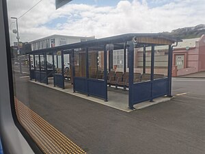
Plimmerton railway station
Railway station in New Zealand
Distance: Approx. 6 meters
Latitude and longitude: -41.08333333,174.86694444
Plimmerton railway station is on the North Island Main Trunk Railway (NIMT) in Plimmerton, Porirua, New Zealand, and is part of Wellington's Metlink suburban rail network operated by Transdev Wellington. It is double tracked around a long island platform, with subway access from Steyne Avenue and Plimmerton Domain's Park and Ride to the north, and a controlled crossing to Steyne Avenue and Mainline Steam at the south end of the platform. Mainline Steam, a heritage steam train restorer and operator, is located in the former goods yard next to the station.
Mana railway station
Railway station in New Zealand
Distance: Approx. 1362 meters
Latitude and longitude: -41.0955,174.8682
Mana railway station on the Kapiti Line section of the North Island Main Trunk Railway (NIMT) in the locality of Mana in the Paremata suburb of the city of Porirua, New Zealand is part of Wellington's Metlink suburban rail network. It is double tracked with a platform each side and a subway between them.

Hongoeka
Suburb in Porirua, New Zealand
Distance: Approx. 2308 meters
Latitude and longitude: -41.06614722,174.85154167
Hongoeka is a community in the city of Porirua in New Zealand. It is northwest of Plimmerton and adjacent to Hongoeka Bay. It extends from an urupā (cemetery) boundary at the end of Moana Road, to Haukōpua (commonly known as Big Bay).
Weather in this IP's area
broken clouds
8 Celsius
6 Celsius
8 Celsius
10 Celsius
991 hPa
82 %
991 hPa
991 hPa
10000 meters
4.18 m/s
5.82 m/s
166 degree
78 %
06:18:44
18:11:40