Country:
 New Zealand
Region:
City:
Latitude and Longitude:
Time Zone:
Postal Code:
IP information under different IP Channel
ip-api
Country
Region
City
ASN
Time Zone
ISP
Blacklist
Proxy
Latitude
Longitude
Postal
Route
IPinfo
Country
Region
City
ASN
Time Zone
ISP
Blacklist
Proxy
Latitude
Longitude
Postal
Route
MaxMind
Country
Region
City
ASN
Time Zone
ISP
Blacklist
Proxy
Latitude
Longitude
Postal
Route
Luminati
Country
NZASN
Time Zone
Pacific/Auckland
ISP
Two Degrees Networks Limited
Latitude
Longitude
Postal
db-ip
Country
Region
City
ASN
Time Zone
ISP
Blacklist
Proxy
Latitude
Longitude
Postal
Route
ipdata
Country
Region
City
ASN
Time Zone
ISP
Blacklist
Proxy
Latitude
Longitude
Postal
Route
Popular places and events near this IP address

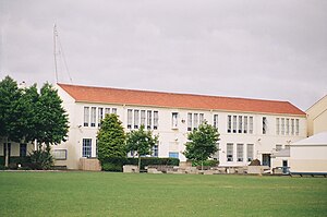
Auckland Grammar School
New Zealand state run secondary school for boys
Distance: Approx. 584 meters
Latitude and longitude: -36.86916667,174.76944444
Auckland Grammar School (often simplified to Auckland Grammar, or Grammar), established in 1869, is a state, day and boarding secondary school for boys in Auckland, New Zealand. The school was originally situated on Howe Street in Freeman’s Bay, where Auckland Girls Grammar School is now located. It moved to its current site on Mountain Road in Epsom in 1916.

Newmarket, New Zealand
Suburb in Auckland, New Zealand
Distance: Approx. 164 meters
Latitude and longitude: -36.869862,174.777578
Newmarket (Māori: Te Tī Tūtahi) is an Auckland suburb to the south-east of the central business district. With its high building density, especially of retail shops, it is considered New Zealand's premier retailing area, and a rival of local competitor Auckland CBD. While as early as 1873, Newmarket has been referred to as a 'suburb' of Auckland, in fact until the amalgamation of the borough councils into Auckland City Council in 1989, local governance was by the Newmarket Borough Council, with its own mayor. The borough, while one of the smallest in the Auckland Region, was also one of the busiest.
St Peter's College, Auckland
School in Auckland, New Zealand
Distance: Approx. 658 meters
Latitude and longitude: -36.8675,174.76888889
St Peter's College (Māori: Te Kura Teitei o Hāto Petera) is a Catholic secondary school for boys in the Edmund Rice tradition, and dedicated to St Peter. It is located in the central Auckland area of Grafton, Auckland, New Zealand. With a roll of over 1300 it is one of the largest catholic schools in New Zealand .

Westfield Newmarket
Shopping mall in Auckland, New Zealand
Distance: Approx. 202 meters
Latitude and longitude: -36.870901,174.776301
Westfield Newmarket is a shopping centre in Newmarket, a central suburb of Auckland, New Zealand. The centre initially opened in the 1980s; in early 2018, the centre closed for a major re-build and expansion; it re-opened in August 2019 after an 18 month closure. The centre is located at 277 Broadway and, since expansion, 309 Broadway; it was often referred to simply as 277 prior to refurbishment.

Newmarket Viaduct
Seven-lane state highway viaduct in Auckland
Distance: Approx. 529 meters
Latitude and longitude: -36.873767,174.777095
The Newmarket Viaduct is a seven-lane state highway viaduct in Auckland, New Zealand. The 700 m long viaduct, which is up to 20 m high, carries the Southern Motorway over the Newmarket suburb.

Newmarket Workshops
Distance: Approx. 233 meters
Latitude and longitude: -36.869899,174.778415
The Newmarket Workshops in Auckland were a major New Zealand Railways Department facility, one of 13 workshops nationwide. It was one of two main railway workshops of Auckland, used mainly for maintenance; the older facility at Newmarket was replaced in 1929 by Otahuhu Workshops.

Southern Cross Auckland Surgical Centre
Hospital in Auckland, New Zealand
Distance: Approx. 606 meters
Latitude and longitude: -36.873692,174.779662
Southern Cross Auckland Surgical Centre is a private day-stay hospital in Remuera, Auckland, New Zealand. It is run by the Southern Cross group. It was established as a private hospital in 1987 (New Zealand's first facility purpose-built for such a use) and was taken over by Southern Cross in 2005.

Grafton railway station, Auckland
Railway station in New Zealand
Distance: Approx. 661 meters
Latitude and longitude: -36.8655,174.7701
Grafton railway station is a station serving the inner-city suburb of Grafton in Auckland, New Zealand. It is located on the Western Line of Auckland's passenger rail network and consists of an island platform located in a trench near the intersection of Khyber Pass Road and Park Road. The station opened on 11 April 2010.

Highwic
Historic house in New Zealand
Distance: Approx. 316 meters
Latitude and longitude: -36.8718,174.7749
Highwic is a 19th-century house in Auckland, New Zealand, which is listed by Heritage New Zealand as a Category I structure. The house was built in 1862 for Alfred Buckland, a wealthy colonial settler and landowner. The building sits in an elevated position above Newmarket.

Khyber Pass Road
Street in central Auckland, New Zealand
Distance: Approx. 692 meters
Latitude and longitude: -36.8657,174.7695
Khyber Pass Road is a street in the Auckland City Centre, New Zealand, connecting Upper Symonds Street to Broadway in Newmarket. The road is intersected by both the Western Line and the Auckland Southern Motorway.
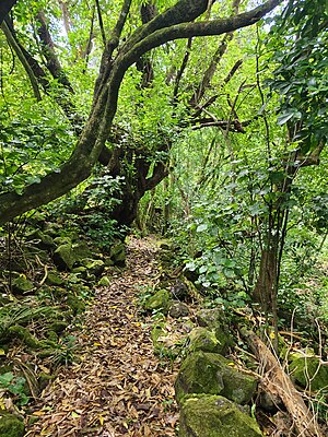
Almorah Rock Forest
Biome on the Auckland isthmus, New Zealand
Distance: Approx. 651 meters
Latitude and longitude: -36.874,174.772
The Almorah Rock Forest (also known as the Epsom Rock Forest) is a lava rock forest located on the northeastern slope of Maungawhau / Mount Eden, in Auckland, New Zealand. It is one of the few remaining lava rock forest patches in the region.

Stoneways
Heritage building in Auckland, New Zealand
Distance: Approx. 559 meters
Latitude and longitude: -36.869556,174.76975
Stoneways is a 1920s home in Epsom, Auckland, New Zealand, listed as a Category I building by Heritage New Zealand. The building was designed by architect William Gummer as his private residence.
Weather in this IP's area
few clouds
11 Celsius
10 Celsius
10 Celsius
12 Celsius
996 hPa
69 %
996 hPa
987 hPa
10000 meters
5.36 m/s
8.05 m/s
293 degree
20 %
06:18:15
18:12:53