Country:
 New Zealand
Region:
City:
Latitude and Longitude:
Time Zone:
Postal Code:
IP information under different IP Channel
ip-api
Country
Region
City
ASN
Time Zone
ISP
Blacklist
Proxy
Latitude
Longitude
Postal
Route
IPinfo
Country
Region
City
ASN
Time Zone
ISP
Blacklist
Proxy
Latitude
Longitude
Postal
Route
MaxMind
Country
Region
City
ASN
Time Zone
ISP
Blacklist
Proxy
Latitude
Longitude
Postal
Route
Luminati
Country
NZRegion
ntl
City
whangarei
ASN
Time Zone
Pacific/Auckland
ISP
Two Degrees Networks Limited
Latitude
Longitude
Postal
db-ip
Country
Region
City
ASN
Time Zone
ISP
Blacklist
Proxy
Latitude
Longitude
Postal
Route
ipdata
Country
Region
City
ASN
Time Zone
ISP
Blacklist
Proxy
Latitude
Longitude
Postal
Route
Popular places and events near this IP address
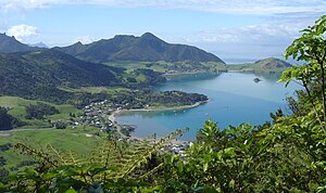
Kamo, New Zealand
Suburb in Whangārei, New Zealand
Distance: Approx. 2092 meters
Latitude and longitude: -35.6835122,174.3135908
Te Kamo is a northern suburb of the New Zealand city of Whangārei. The area was colloquially known as Kamo until 2023. It is approximately five minutes' drive from the centre of Whangārei.

Tikipunga
Suburb in Whangārei, New Zealand
Distance: Approx. 3167 meters
Latitude and longitude: -35.684873,174.328543
Tikipunga is one of the biggest suburbs in Whangārei, New Zealand. It is in the north-east part of the city and has the landmark Whangārei Falls nearby.
Radio Northland
Radio station in Whangārei
Distance: Approx. 3554 meters
Latitude and longitude: -35.7209301,174.320869
Radio Northland was a radio station based in Whangārei, New Zealand. The station was started by Radio New Zealand (which at the time was known as the National Broadcasting Service) in 1949. The original callsign was 1XN and the station was originally known by this name, the callsign was later changed to 1ZN. The station originally broadcast on 970AM in Whangārei (callsign 1ZN), Kaikohe on 1220AM (callsign 1ZE) and Kaitaia on 1440AM (callsign 1ZK).
Hurupaki Mountain
Volcanic field in New Zealand
Distance: Approx. 1957 meters
Latitude and longitude: -35.68293,174.28182
Hurupaki Mountain is in Kamo, Whangārei, New Zealand. The centre of Hurupaki Mountain lies between Three Mile Bush Road and Dip Road, approximately 1.5 kilometres west of Kamo township. Hurupaki Mountain is visible from State Highway 1.
Whangarei District
Territorial authority district in Northland, New Zealand
Distance: Approx. 2806 meters
Latitude and longitude: -35.719,174.309
Whangarei District is a territorial authority district in the Northland Region of New Zealand that is governed by the Whangarei District Council. The district is made up in area largely by rural land, and includes a fifth of the Northland Region. It extends southwards to the southern end of Bream Bay, northwards to Whangaruru and almost to the Bay of Islands, and westwards up the Mangakahia River valley past Pakotai and almost to Waipoua Forest.
Whau Valley
Suburb in Whangārei, New Zealand
Distance: Approx. 1518 meters
Latitude and longitude: -35.69861111,174.31277778
Whau Valley is a suburb of Whangārei, in Northland Region, New Zealand. State Highway 1 runs through it. The valley was named for the whau trees which grew there in the 1850s.
Otangarei
Suburb in Whangarei District Council, New Zealand
Distance: Approx. 2098 meters
Latitude and longitude: -35.69277778,174.31916667
Otangarei is a suburb of Whangārei, in Northland Region, New Zealand. The New Zealand Ministry for Culture and Heritage gives a translation of "place of [a] group of people leaping" for Ōtāngarei. Te Kotahitanga Marae o Otangarei is the community's local marae.
Lake Ora
Lake in New Zealand
Distance: Approx. 1066 meters
Latitude and longitude: -35.699,174.2851
Lake Ora is a lake in the Northland Region of New Zealand.
Three Mile Bush
Suburb in Whangārei, New Zealand
Distance: Approx. 1834 meters
Latitude and longitude: -35.68333333,174.28333333
Three Mile Bush is a suburb of Whangārei in Northland, New Zealand. The population of Three Mile Bush was 999 in the 2013 Census, an increase of 350 from 2006.

Mair Park
Park in Whangārei, New Zealand
Distance: Approx. 3488 meters
Latitude and longitude: -35.71277778,174.32888889
Mair Park is in Whangārei, New Zealand, adjacent to the suburb of Mairtown. It is named for Robert Mair, who donated the land from his estate to the city in 1914. The park includes access to the Hātea River.

Kensington, Whangārei
Suburb in Whangārei, New Zealand
Distance: Approx. 2234 meters
Latitude and longitude: -35.71,174.314
Kensington (Māori: Tawatawhiti) is a suburb of Whangārei, in Northland Region, New Zealand. It is about 2 kilometres north of the city centre. State Highway 1 runs through Kensington, The Western Hills form a boundary on the west, and Hātea River on the east.

Mairtown
Suburb in Whangārei, New Zealand
Distance: Approx. 2918 meters
Latitude and longitude: -35.708,174.325
Mairtown is a suburb of Whangārei, in Northland Region, New Zealand. It is about 2 kilometres north of the city centre. Mair Park runs between Mairtown and the Hātea River.
Weather in this IP's area
broken clouds
11 Celsius
10 Celsius
11 Celsius
11 Celsius
999 hPa
85 %
999 hPa
984 hPa
10000 meters
4.49 m/s
13.56 m/s
275 degree
59 %
06:19:56
18:15:01