Country:
Region:
City:
Latitude and Longitude:
Time Zone:
Postal Code:
IP information under different IP Channel
ip-api
Country
Region
City
ASN
Time Zone
ISP
Blacklist
Proxy
Latitude
Longitude
Postal
Route
Luminati
Country
Region
ntl
City
kerikeri
ASN
Time Zone
Pacific/Auckland
ISP
Two Degrees Networks Limited
Latitude
Longitude
Postal
IPinfo
Country
Region
City
ASN
Time Zone
ISP
Blacklist
Proxy
Latitude
Longitude
Postal
Route
db-ip
Country
Region
City
ASN
Time Zone
ISP
Blacklist
Proxy
Latitude
Longitude
Postal
Route
ipdata
Country
Region
City
ASN
Time Zone
ISP
Blacklist
Proxy
Latitude
Longitude
Postal
Route
Popular places and events near this IP address
Marsden B
Distance: Approx. 7410 meters
Latitude and longitude: -35.875474,174.468041
Marsden B was an unused 250 MW oil-fired power station near the Marsden Point Oil Refinery at Marsden Point, Ruakaka, Northland, New Zealand. Due to rising oil prices, the plant was mothballed in 1978 without ever being commissioned. The Marsden site also includes the Marsden A power station, now a synchronous compensation facility owned and operated by Mercury Energy.
Marsden Point
Peninsula in New Zealand
Distance: Approx. 3083 meters
Latitude and longitude: -35.840986,174.494734
Marsden Point is a broad, flat peninsula that is the southern head of the Whangārei Harbour entrance on the east coast of Northland, New Zealand, 30 kilometres (19 mi) southeast of the city of Whangārei. It is the location of Marsden Point Oil Refinery and the Northport cargo port.
Marsden Point Oil Refinery
Former oil refinery in New Zealand
Distance: Approx. 3083 meters
Latitude and longitude: -35.840986,174.494734
Marsden Point Oil Refinery was a 96,000 BPD refinery located at Marsden Point, Whangārei, Northland, New Zealand. It was the only oil refinery in New Zealand, and was operated by Refining NZ. The point was named after Samuel Marsden. The regional survey map shows it was called Marsden Point in 1907.
Taurikura
Place in Northland Region, New Zealand
Distance: Approx. 2533 meters
Latitude and longitude: -35.82266667,174.52333333
Taurikura is a small, rural township in the Whangarei District, approximately 30 kilometres (19 mi) south east of Whangārei city in Northland, New Zealand. The town is located on the shores of Calliope Bay at the base of 420-metre-high (1,380 ft) Mount Manaia which, along with Bream Head and the Hen Island, collectively form the ancient remnants of a very large andesitic volcano. Features of Taurikura include a Baptist-owned camp and a permanently closed general store.
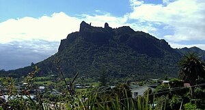
Mount Manaia
Volcanic mountain in New Zealand
Distance: Approx. 1173 meters
Latitude and longitude: -35.8175,174.50966667
Mount Manaia is a dominant landmark approximately 30 kilometres southeast of Whangārei city on the Whangārei Heads peninsula. Standing 420 metres, the summit offers outstanding views of the Marsden Point Oil Refinery, Bream Bay and the Hauraki Gulf to the south, Whangārei Harbour to the west and the Poor Knights Islands and Northland coast to the north. Mt Manaia - along with Mt Lion, Bream Head and the Hen and Chicken Islands, are the scattered remnants of andesite, volcanic intusions that erupted with force 16 to 22 million years ago during the early Miocene.
Marsden Bay, New Zealand
Place in Northland Region, New Zealand
Distance: Approx. 3505 meters
Latitude and longitude: -35.83138889,174.46583333
Marsden Bay is a locality and bay at the south head of Whangārei Harbour in Northland, New Zealand. The western side of Marsden Bay is a coastal community called One Tree Point, and the eastern side is the industrial development of Marsden Point. Ruakākā lies about 9 km to the south.

One Tree Point, New Zealand
Place in Northland Region, New Zealand
Distance: Approx. 3994 meters
Latitude and longitude: -35.819,174.454
One Tree Point is a settlement on the southern side of Whangārei Harbour in Northland, New Zealand. The settlement includes the Marsden Point Marina.

Parua Bay
Place in Northland Region, New Zealand
Distance: Approx. 5954 meters
Latitude and longitude: -35.77,174.45916667
Parua Bay is a locality and bay on the northern side of the Whangārei Harbour in Northland, New Zealand. Whangārei is 19 km to the west, and Whangārei Heads are 10 km to the south east, with Munro Bay between the two. The western head is called Manganese Point, and the eastern is Reserve Point.

Whangārei Heads
Place in Northland Region, New Zealand
Distance: Approx. 702 meters
Latitude and longitude: -35.81722222,174.50388889
Whangārei Heads is a locality and volcanic promontory on the northern side of the Whangārei Harbour in Northland, New Zealand. Whangārei is 29 km (18 mi) to the north-west, and Ocean Beach is 8 km (5.0 mi) to the south-east, with Taurikura between the two. Mount Manaia rises to 420 metres (1,380 feet) to the east.

Marsden A
Distance: Approx. 7410 meters
Latitude and longitude: -35.875474,174.468041
Marsden A was a 250 MW oil-fired power station near the Marsden Point Oil Refinery at Marsden Point, Ruakaka, Northland, New Zealand. It was built between 1964 and 1966 and commissioned in 1967. It acted as an emergency reserve power station, serving the load centre of Auckland to the south.
Awarua Rock
Island off the coast of Northland, New Zealand
Distance: Approx. 6229 meters
Latitude and longitude: -35.78472222,174.55694444
Awarua Rock is an unofficial name for an island on the coast of New Zealand's Northland Region. It is located on the Pacific coast, north of the entrance to Whangārei Harbour.
Calliope Island
Island in North Auckland, New Zealand
Distance: Approx. 4075 meters
Latitude and longitude: -35.84166667,174.52638889
Calliope Island is an unofficial name for an island near Whangārei, New Zealand. The tiny, roughly triangular-shaped island, is located in Urquhart Bay, just within the mouth of Whangārei Harbour. In the early 20th or late 19th century, Calliope Island's plant life was subject to illegal burning.
Weather in this IP's area
scattered clouds
10 Celsius
8 Celsius
10 Celsius
10 Celsius
1021 hPa
73 %
1021 hPa
1021 hPa
10000 meters
3.22 m/s
5.6 m/s
216 degree
29 %
06:15:30
19:55:36

