161.179.129.9 - IP Lookup: Free IP Address Lookup, Postal Code Lookup, IP Location Lookup, IP ASN, Public IP
Country:
 USA
USARegion:
City:
Location:
Time Zone:
Postal Code:
ISP:
ASN:
language:
User-Agent:
Proxy IP:
Blacklist:
IP information under different IP Channel
ip-api
Country
Region
City
ASN
Time Zone
ISP
Blacklist
Proxy
Latitude
Longitude
Postal
Route
db-ip
Country
Region
City
ASN
Time Zone
ISP
Blacklist
Proxy
Latitude
Longitude
Postal
Route
IPinfo
Country
Region
City
ASN
Time Zone
ISP
Blacklist
Proxy
Latitude
Longitude
Postal
Route
IP2Location
161.179.129.9Country
usRegion
iowa
City
cedar rapids
Time Zone
America/Chicago
ISP
Language
User-Agent
Latitude
Longitude
Postal
ipdata
Country
Region
City
ASN
Time Zone
ISP
Blacklist
Proxy
Latitude
Longitude
Postal
Route
Popular places and events near this IP address
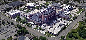
Mercy Medical Center (Cedar Rapids, Iowa)
Hospital in Iowa, United States
Distance: Approx. 416 meters
Latitude and longitude: 41.978,-91.656
Mercy Medical Center is a Catholic hospital in Cedar Rapids, Iowa. The smaller of two metro hospitals, Mercy frequently ranks as either the best in Iowa or one of the top three. Mercy is a non-profit, acute-care medical center with a level III trauma center.

Metro High School (Iowa)
Public secondary school in Cedar Rapids, Iowa, United States
Distance: Approx. 428 meters
Latitude and longitude: 41.97271,-91.6536
Metro High School is located in Cedar Rapids, Iowa and is part of the Cedar Rapids Community School District.

United States District Court for the Northern District of Iowa
United States federal district court in Iowa
Distance: Approx. 544 meters
Latitude and longitude: 41.97258333,-91.66408333
The United States District Court for the Northern District of Iowa (in case citations, N.D. Iowa) has jurisdiction over fifty-two of Iowa's ninety-nine counties. It is subject to the Eighth Circuit Court of Appeals (except for patent claims and claims against the U.S. government under the Tucker Act, which are appealed to the Federal Circuit). The United States District Court for the District of Iowa, established on March 3, 1845, by 5 Stat.

Bethel African Methodist Episcopal Church (Cedar Rapids, Iowa)
United States historic place
Distance: Approx. 379 meters
Latitude and longitude: 41.97763889,-91.66016667
Bethel African Methodist Episcopal Church is located in Cedar Rapids, Iowa, United States. The congregation was established in either 1870 or 1871, which makes this the oldest historically African American church in the city. It had 23 pastors from its inception to 1928, which followed the African Methodist Episcopal Church's practice of itinerant pastors.
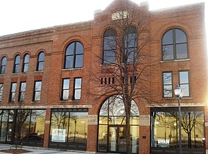
C.S.P.S. Hall (Cedar Rapids, Iowa)
United States historic place
Distance: Approx. 421 meters
Latitude and longitude: 41.97083333,-91.65861111
The C.S.P.S. Hall in Cedar Rapids, Iowa, USA was built during 1890-91 and expanded twice in the next two decades. It was a social and cultural center of the local Czech-Slovak Protective Society (C.S.P.S.). The building was individually listed on the National Register of Historic Places in 1978.
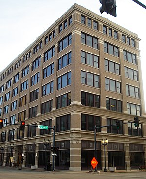
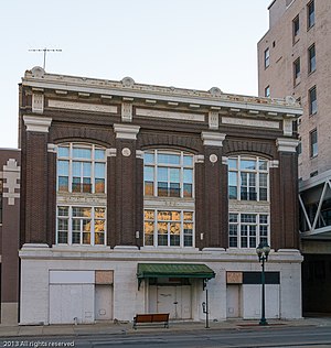
Iowa Building
United States historic place
Distance: Approx. 594 meters
Latitude and longitude: 41.97666667,-91.66472222
The Iowa Building is a historic structure located in downtown Cedar Rapids, Iowa, United States. It was individually listed on the National Register of Historic Places in 1983. In 2015 it was included as a contributing property in the Cedar Rapids Central Business District Commercial Historic District.
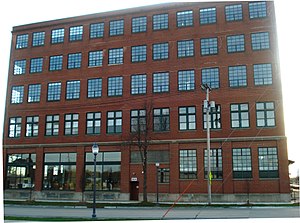
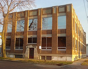
Witwer Grocery Company Building
United States historic place
Distance: Approx. 310 meters
Latitude and longitude: 41.9725,-91.66055556
The Witwer Grocery Company Building, also known as the Osada Building or more recently as the Bottleworks Loft Condominiums, is a historic structure located in Cedar Rapids, Iowa, United States. The building served as the grocery warehouse for the Witwer Grocery Company, a local Cedar Rapids grocer which included MeToo stores from 1946 to 1965 and had a bottling facility for Life Cola and Hires Root Beer on the first floor. The building is five stories tall and rises 55 feet (17 m) above the ground.
Evans Manufacturing Company Building
United States historic place
Distance: Approx. 395 meters
Latitude and longitude: 41.97505556,-91.66283333
The Evans Manufacturing Company Building, also known as Metropolitan Supply Company Building, is a historic building located in Cedar Rapids, Iowa, United States. The Brown-Evans Manufacturing Company, which made men's work clothing, was relocated from Sedalia, Missouri to Cedar Rapids when this building was completed in 1919. It was built in the 4th Street Railroad Corridor, which had attracted various industrial enterprises in the years before and after World War I. The Modern Movement building was designed according to the principles of industrial design of the time in light of the Triangle Shirtwaist Factory fire in 1911.
Sokol Gymnasium
United States historic place
Distance: Approx. 566 meters
Latitude and longitude: 41.97616667,-91.66461111
Sokol Gymnasium is a historic building located in Cedar Rapids, Iowa, United States. Sokol is a Czech social and gymnastics organization. It had this three-story, brick, Neoclassical structure built in 1908.

Best Oil and Refining Company Service Station
United States historic place
Distance: Approx. 386 meters
Latitude and longitude: 41.97280556,-91.65411111
The Best Oil and Refining Company Service Station is a historic building located in Cedar Rapids, Iowa, United States. This was the third service station built by business partners George D. Shaler and George J. Albright. Albright had previously been a building contractor and had owned a lumberyard, while Shaler was one of the founders of the Best Oil Company.

Harper and McIntire Company Warehouse
United States historic place
Distance: Approx. 304 meters
Latitude and longitude: 41.97577778,-91.66141667
The Harper and McIntire Company Warehouse, also known as Smulekoff's Warehouse, is a historic building located in Cedar Rapids, Iowa, United States. Harper and Mcintire was a wholesale hardware business that was established in Ottumwa, Iowa in 1856. A branch warehouse in Cedar Rapids was begun in 1921.

Glenn M. and Edith Averill House
Historic house in Iowa, United States
Distance: Approx. 578 meters
Latitude and longitude: 41.97922222,-91.66127778
The Glenn M. and Edith Averill House is a historic building located in Cedar Rapids, Iowa, United States. Designed by local architectural firm Josselyn & Taylor, it was completed in 1906 in a combination of the Queen Anne style and the American Craftsman style. It replaced a smaller house that was located on its original lot at 1113 2nd Avenue, SE. The Averill's lived here until 1913 when they moved into a new residence and rented out this home.
Weather in this IP's area
overcast clouds
-1 Celsius
-5 Celsius
-1 Celsius
-0 Celsius
1024 hPa
53 %
1024 hPa
993 hPa
10000 meters
3.6 m/s
120 degree
100 %