Country:
 USA
USARegion:
City:
Latitude and Longitude:
Time Zone:
Postal Code:
IP information under different IP Channel
ip-api
Country
Region
City
ASN
Time Zone
ISP
Blacklist
Proxy
Latitude
Longitude
Postal
Route
IPinfo
Country
Region
City
ASN
Time Zone
ISP
Blacklist
Proxy
Latitude
Longitude
Postal
Route
MaxMind
Country
Region
City
ASN
Time Zone
ISP
Blacklist
Proxy
Latitude
Longitude
Postal
Route
Luminati
Country
USASN
Time Zone
America/Chicago
ISP
WAL-MART-2
Latitude
Longitude
Postal
db-ip
Country
Region
City
ASN
Time Zone
ISP
Blacklist
Proxy
Latitude
Longitude
Postal
Route
ipdata
Country
Region
City
ASN
Time Zone
ISP
Blacklist
Proxy
Latitude
Longitude
Postal
Route
Popular places and events near this IP address
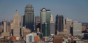
Kansas City, Missouri
City in Missouri, United States
Distance: Approx. 23 meters
Latitude and longitude: 39.09972222,-94.57833333
Kansas City, Missouri (KC or KCMO) is the largest city in the U.S. state of Missouri by population and area. Most of the city lies within Jackson County, and other portions spill into Clay, Platte, and Cass counties. It is the central city of the Kansas City metropolitan area, which straddles the Missouri–Kansas state line and has a population of 2,392,035.
National Collegiate Basketball Hall of Fame
Museum in Kansas City, Missouri
Distance: Approx. 222 meters
Latitude and longitude: 39.09836,-94.5805
The National Collegiate Basketball Hall of Fame, located in Kansas City, Missouri, is a hall of fame and museum dedicated to men's college basketball. The museum is an integral portion of the College Basketball Experience created by the National Association of Basketball Coaches (NABC), located at the T-Mobile Center. The hall is meant as a complement to the Naismith Memorial Basketball Hall of Fame, with a focus strictly on those who have contributed greatly to college basketball.

Kansas City City Hall
City hall building in Kansas City, Missouri
Distance: Approx. 110 meters
Latitude and longitude: 39.100569,-94.577997
Kansas City City Hall is the official seat of government for the city of Kansas City, Missouri, United States. Located in downtown, it is a 29-story skyscraper with an observation deck. Completed in 1937, the building has a Beaux-Arts and Art-Deco style with numerous architectural features and ornamentation throughout.
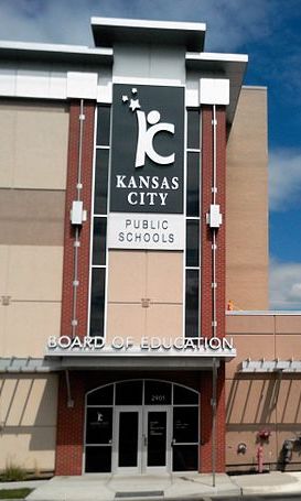
Kansas City Public Schools
School district in Kansas City, Missouri, United States
Distance: Approx. 56 meters
Latitude and longitude: 39.0994,-94.57912
Kansas City 33 School District, operating as Kansas City Public Schools or KCPS (formerly Kansas City, Missouri School District, or KCMSD), is a school district headquartered at 2901 Troost Avenue in Kansas City, Missouri, United States. The district, which lost accreditation in 2011, regained provisional accreditation from the state in 2014. In November 2016, the district announced it had gotten a high enough score on state accountability measures for the State Board of Education to consider full accreditation.

Jackson County Courthouse (Kansas City, Missouri)
Court house in Kansas City, Missouri
Distance: Approx. 76 meters
Latitude and longitude: 39.0992,-94.578
Jackson County Courthouse in Kansas City, Missouri is located at 415 East 12th Street in Downtown Kansas City and houses judicial and administrative offices for the western portion of the county. It was built in 1934, designed by Wight and Wight in an Art Deco style. Harry S. Truman, presiding judge of the Jackson County Court at the time, wanted it designed similar to the Caddo Parish, Louisiana courthouse in Shreveport, Louisiana by Edward F. Neild.

Oak Tower
Skyscraper in Kansas City, Missouri
Distance: Approx. 169 meters
Latitude and longitude: 39.1012,-94.5789
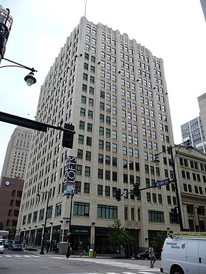
Oak Tower, also called the Bell Telephone Building, is a 28-story skyscraper in Downtown Kansas City, Missouri. Hoit, Price & Barnes, a local firm that conceived many of Kansas City's landmark structures, designed the building in association with I.R. Timlin as the headquarters of the Bell Telephone Co.'s newly consolidated Southwestern System. The ground was broken at Eleventh and Oak Streets in 1917, but due to shortages of manpower and materials during the First World War, construction was delayed and was not completed until 1920.
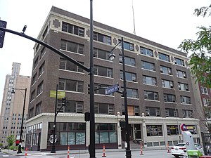
Inter-State Building
United States historic place
Distance: Approx. 170 meters
Latitude and longitude: 39.09831,-94.57779
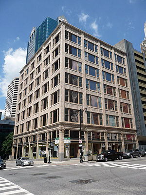
The Inter-State Building is a six-story commercial building in the central business district of Kansas City, Missouri, that was built during 1914–15. It was listed on the National Register of Historic Places in 2008. It was designed by Kansas City, Missouri, architect James C. Sunderland in Chicago style.
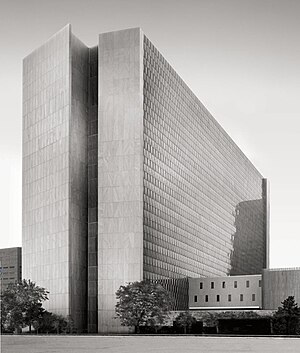
Richard Bolling Federal Building
United States historic place
Distance: Approx. 238 meters
Latitude and longitude: 39.0988,-94.5761
The Richard Bolling Federal Building is a United States federal building located at 601 East 12th Street in Kansas City, Missouri. Completed in 1965, the building is bordered by East Twelfth, East Thirteenth, Locust, and Holmes streets in the Central Business District in Kansas City. The building was named for Congressman Richard Walker Bolling in 1994.

Jenkins Music Company Building
United States historic place
Distance: Approx. 243 meters
Latitude and longitude: 39.09944444,-94.58138889
The Jenkins Music Company Building is a historic building in the Kansas City Power and Light District in Kansas City, Missouri. Built in 1911, it is a significant example of unaltered, Modernistic style commercial architecture, combining Late Gothic Revival and Art Deco decorative elements. It was listed on the National Register of Historic Places in 1979.
Palace Clothing Company Building
United States historic place
Distance: Approx. 196 meters
Latitude and longitude: 39.1,-94.58083333
The Palace Clothing Company Building in Kansas City, Missouri is a building constructed in 1924. It was listed on the National Register of Historic Places in 1985.
Professional Building (Kansas City, Missouri)
United States historic place
Distance: Approx. 192 meters
Latitude and longitude: 39.10083333,-94.58027778
The Professional Building in Kansas City, Missouri is a building from 1923. It was listed on the National Register of Historic Places in 1982.
Timeline of Kansas City, Missouri
City history timeline
Distance: Approx. 23 meters
Latitude and longitude: 39.099722,-94.578333
The following is a timeline of the history of Kansas City, Missouri, United States.
Weather in this IP's area
broken clouds
32 Celsius
36 Celsius
31 Celsius
33 Celsius
1004 hPa
56 %
1004 hPa
974 hPa
10000 meters
3.6 m/s
140 degree
75 %
07:03:44
19:20:11