161.129.23.240 - IP Lookup: Free IP Address Lookup, Postal Code Lookup, IP Location Lookup, IP ASN, Public IP
Country:
Region:
City:
Location:
Time Zone:
Postal Code:
ISP:
ASN:
language:
User-Agent:
Proxy IP:
Blacklist:
IP information under different IP Channel
ip-api
Country
Region
City
ASN
Time Zone
ISP
Blacklist
Proxy
Latitude
Longitude
Postal
Route
db-ip
Country
Region
City
ASN
Time Zone
ISP
Blacklist
Proxy
Latitude
Longitude
Postal
Route
IPinfo
Country
Region
City
ASN
Time Zone
ISP
Blacklist
Proxy
Latitude
Longitude
Postal
Route
IP2Location
161.129.23.240Country
Region
illinois
City
burlington
Time Zone
America/Chicago
ISP
Language
User-Agent
Latitude
Longitude
Postal
ipdata
Country
Region
City
ASN
Time Zone
ISP
Blacklist
Proxy
Latitude
Longitude
Postal
Route
Popular places and events near this IP address

Burlington, Illinois
Village in Illinois, United States
Distance: Approx. 3600 meters
Latitude and longitude: 42.05138889,-88.55055556
Burlington is a village in Kane County, Illinois, United States. The population was 429 as of 2022 estimates. It was incorporated as a village on November 6, 1990.

Hampshire, Illinois
Village in Illinois, United States
Distance: Approx. 6201 meters
Latitude and longitude: 42.11388889,-88.47583333
Hampshire is a village in Kane and McHenry counties, Illinois, United States. As of the 2020 census it had a population of 7,667.
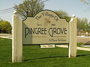
Pingree Grove, Illinois
Village in Illinois, United States
Distance: Approx. 6598 meters
Latitude and longitude: 42.08555556,-88.43611111
Pingree Grove ( PING-GREE) is a village in Kane County, Illinois, United States. The population was 124 at the 2000 census. However, with rapid development in the following years, the 2010 census indicated 4,532 residents, and the 2020 census was 10,365.
Starks, Illinois
Unincorporated community in Illinois, United States
Distance: Approx. 5195 meters
Latitude and longitude: 42.08833333,-88.45666667
Starks is an unincorporated community in Kane County in the U.S. state of Illinois, located just south of the McHenry County border. Hampshire lies to its northwest, and Pingree Grove lies to its southeast. In the Illinois highway system, Starks is noted for having a wrong-way concurrency.

Burlington Township, Illinois
Township in Illinois, United States
Distance: Approx. 5004 meters
Latitude and longitude: 42.03,-88.54944444
Burlington Township is located in Kane County, Illinois. As of the 2010 census, its population was 1,921 and it contained 734 housing units. Most of its land use is agricultural.

Hampshire Township, Illinois
Township in Illinois, United States
Distance: Approx. 5105 meters
Latitude and longitude: 42.10805556,-88.53055556
Hampshire Township is located in the northwest corner of Kane County, Illinois. As of the 2010 census, its population was 7,569 and it contained 2,926 housing units.
Central High School (Burlington, Illinois)
Public high school in Burlington, Kane, Illinois, United States
Distance: Approx. 5552 meters
Latitude and longitude: 42.019057,-88.483425
Central High School, is a public four-year high school located in Kane County, Illinois, a far northwest suburb of Chicago, Illinois, United States. It is part of Central Community Unit School District 301, which serves Elgin, Lily Lake, Plato Center, Udina, Hampshire, Pingree Grove, Sycamore, Maple Park, Campton Hills, Burlington and far western portions of St. Charles.
Allens Corners, Illinois
Unincorporated community in Illinois, United States
Distance: Approx. 4577 meters
Latitude and longitude: 42.09944444,-88.48138889
Allen's Corners is an unincorporated community in Kane County, Illinois, United States. Allen's Corner is a landmark of the Allen family, the first settlers of Kane County in 1836. First known as blacksmiths and farmers, the towing business was started in 1937.
Hampshire High School (Illinois)
School in Hampshire, Kane, Illinois, United States
Distance: Approx. 6558 meters
Latitude and longitude: 42.1228,-88.498521
Hampshire High School (Illinois) (commonly referred to as Hampshire or HHS) is a public high school for students in grades 9 through 12 located in Hampshire, Illinois, United States. t serves students from Hampshire and surrounding areas, including Gilberts, Pingree Grove, Carpentersville, Elgin, and Sleepy Hollow. The school is located at the northern edge of Hampshire.
Ella Johnson Memorial Public Library
Library in Hampshire, Illinois
Distance: Approx. 4132 meters
Latitude and longitude: 42.0989,-88.5299
The Ella Johnson Memorial Public Library, located in Hampshire, Illinois, serves the approximately 16,000 residents of Hampshire, Burlington, Pingree Grove, in addition to parts of the neighboring areas of Elgin and Huntley. The Library covers a 100 square mile area in Kane County, including the Hampshire Township, plus areas of the Burlington Township, Plato Township, and Rutland Township. The 7,200-square-foot library has a collection of over 49,885 in-house items.
North Plato, Illinois
Unincorporated community in Illinois, United States
Distance: Approx. 3992 meters
Latitude and longitude: 42.055035,-88.464248
North Plato is an unincorporated community in Kane County, Illinois, United States, located directly northwest of Plato Center. It is about equidistant between Hampshire and Plato Center. The center of the community is located exactly near the intersection of Plank Road and Illinois Route 47.

Robert and Elizabeth Muirhead House
Historic house in Illinois, United States
Distance: Approx. 5921 meters
Latitude and longitude: 42.03583333,-88.45055556
The Robert and Elizabeth Muirhead House is a historic house located at 42W814 Rohrson Road northeast of Plato Center, Illinois. Built in 1951–53, the house was designed by Frank Lloyd Wright in his Usonian style. Robert and Elizabeth Muirhead, the home's owners, had met Wright in 1948 while touring Taliesin, and the meeting inspired them to commission Wright to design their own home.
Weather in this IP's area
overcast clouds
-8 Celsius
-12 Celsius
-9 Celsius
-6 Celsius
1023 hPa
60 %
1023 hPa
988 hPa
10000 meters
2.24 m/s
4.47 m/s
207 degree
100 %
