161.129.2.22 - IP Lookup: Free IP Address Lookup, Postal Code Lookup, IP Location Lookup, IP ASN, Public IP
Country:
Region:
City:
Location:
Time Zone:
Postal Code:
IP information under different IP Channel
ip-api
Country
Region
City
ASN
Time Zone
ISP
Blacklist
Proxy
Latitude
Longitude
Postal
Route
Luminati
Country
ASN
Time Zone
America/Chicago
ISP
IDEALCLOUD
Latitude
Longitude
Postal
IPinfo
Country
Region
City
ASN
Time Zone
ISP
Blacklist
Proxy
Latitude
Longitude
Postal
Route
IP2Location
161.129.2.22Country
Region
florida
City
tampa
Time Zone
America/New_York
ISP
Language
User-Agent
Latitude
Longitude
Postal
db-ip
Country
Region
City
ASN
Time Zone
ISP
Blacklist
Proxy
Latitude
Longitude
Postal
Route
ipdata
Country
Region
City
ASN
Time Zone
ISP
Blacklist
Proxy
Latitude
Longitude
Postal
Route
Popular places and events near this IP address

Hillsborough County, Florida
County in Florida, United States
Distance: Approx. 3467 meters
Latitude and longitude: 27.91,-82.35
Hillsborough County is located in the west-central portion of the U.S. state of Florida. In the 2020 census, the population was 1,459,762, making it the fourth-most populous county in Florida and the most populous county outside the Miami metropolitan area. A 2021 estimate has the population of Hillsborough County at 1,512,070 people with a yearly growth rate of 1.34%, which itself is greater than the populations of 12 states according to their 2019 population estimates.

Palm River-Clair Mel, Florida
Census-designated place in Florida, United States
Distance: Approx. 523 meters
Latitude and longitude: 27.92805556,-82.37888889
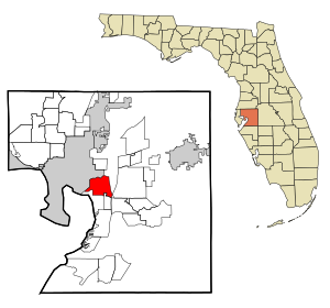
Palm River-Clair Mel is a census-designated place (CDP) in Hillsborough County, Florida, United States. The population was 21,024 at the 2010 census, up from 17,589 at the 2000 census. The census area includes the unincorporated communities of Clair-Mel City and Palm River.

Progress Village, Florida
Census-designated place in Florida, United States
Distance: Approx. 4095 meters
Latitude and longitude: 27.89638889,-82.36333333
Progress Village is a census-designated place (CDP) in Hillsborough County, Florida, United States. Per the 2020 census, the population was 11,188.
Uceta Yard
Neighborhood in Hillsborough, Florida, United States
Distance: Approx. 3691 meters
Latitude and longitude: 27.95972222,-82.39527778
Uceta Yard is a rail yard in a non-residential section within the city limits of Tampa. The ZIP Code serving the community is 33619.
WQYK-FM
Country music radio station in St. Petersburg, Florida
Distance: Approx. 2518 meters
Latitude and longitude: 27.932,-82.401
WQYK-FM (99.5 MHz, currently branded 99.5 QYK) is a commercial country music radio station in Tampa, Florida. It is under ownership of Beasley Broadcast Group. Its studios are in St.
Clair-Mel City, Florida
Unincorporated community in Florida, United States
Distance: Approx. 347 meters
Latitude and longitude: 27.93333333,-82.37833333
Clair-Mel City (Clair Mel) is an unincorporated community in Hillsborough County, Florida, United States. The community is combined with Palm River to form the census-designated place of Palm River-Clair Mel.
Tampa Bypass Canal
River in the United States of America
Distance: Approx. 3969 meters
Latitude and longitude: 27.942,-82.414
The Tampa Bypass Canal and Palm River are a 14-mile-long (23 km) flood bypass operated by the Southwest Florida Water Management District. The canal includes several concrete flood control structures and was constructed during the 1960s and 1970s. Its purpose is to redirect flood waters from large amounts of rainfall from the Hillsborough River to Tampa Bay to prevent floodwaters reaching homes and businesses.
WAMA (AM)
Regional Mexican radio station in Tampa, Florida
Distance: Approx. 2426 meters
Latitude and longitude: 27.91805556,-82.39472222
WAMA (1550 kHz) is an AM radio station broadcasting a Regional Mexican format. Licensed to Tampa, Florida, United States, it serves the Tampa Bay area. The station is currently owned by George and Esperanza Arroyo, through licensee Q Broadcasting Corporation.
Palm River, Florida
Unincorporated community in Florida, United States
Distance: Approx. 2412 meters
Latitude and longitude: 27.94194444,-82.39694444
Palm River is an unincorporated community located in Hillsborough County, Florida, United States. It shares its name with the Palm River, a waterway sided with trail. Palm River boundaries include McKay Bay to the west, Tampa city limits to the north, the Clair Mel to the east, and Progress Village to the south.
Dixie Farms
Neighborhood in Hillsborough, Florida, United States
Distance: Approx. 3798 meters
Latitude and longitude: 27.96194444,-82.39305556
Dixie Farms is a neighborhood near the district of Uceta Yard, which represents District 5 of the Tampa City Council. The 2000 census numbers were unavailable, however, the latest estimated population was 34 and the population density was 249 people per square mile.
Wat Mongkolratanaram (Tampa, Florida)
Buddhist Thai temple
Distance: Approx. 2345 meters
Latitude and longitude: 27.9432,-82.3953
Wat Mongkolratanaram is a Buddhist Thai temple on the bank of the Palm River in Tampa, Florida. It was founded in 1981 as well as dedicated and registered as a temple on 19 May 1981. Besides a temple, it acts as an education and support centre.
Tampa–Hillsborough County Public Library System
Public library system in Florida
Distance: Approx. 1048 meters
Latitude and longitude: 27.940388,-82.371586
The Tampa–Hillsborough County Public Library System (THPL) is a public library system based in Hillsborough County, Florida, United States. It is part of two larger library networks, the Tampa Bay Library Consortium, and the Hillsborough County Public Library Cooperative, which includes Temple Terrace Public Library in Temple Terrace, and Bruton Memorial Library in Plant City. There are 33 branches of the Hillsborough County Public Library Cooperative.
Weather in this IP's area
overcast clouds
15 Celsius
15 Celsius
14 Celsius
17 Celsius
1016 hPa
91 %
1016 hPa
1016 hPa
10000 meters
2.24 m/s
4.47 m/s
161 degree
100 %