161.121.209.127 - IP Lookup: Free IP Address Lookup, Postal Code Lookup, IP Location Lookup, IP ASN, Public IP
Country:
Region:
City:
Location:
Time Zone:
Postal Code:
ISP:
ASN:
language:
User-Agent:
Proxy IP:
Blacklist:
IP information under different IP Channel
ip-api
Country
Region
City
ASN
Time Zone
ISP
Blacklist
Proxy
Latitude
Longitude
Postal
Route
db-ip
Country
Region
City
ASN
Time Zone
ISP
Blacklist
Proxy
Latitude
Longitude
Postal
Route
IPinfo
Country
Region
City
ASN
Time Zone
ISP
Blacklist
Proxy
Latitude
Longitude
Postal
Route
IP2Location
161.121.209.127Country
Region
new york
City
new york city
Time Zone
America/New_York
ISP
Language
User-Agent
Latitude
Longitude
Postal
ipdata
Country
Region
City
ASN
Time Zone
ISP
Blacklist
Proxy
Latitude
Longitude
Postal
Route
Popular places and events near this IP address

Queen Elizabeth II September 11th Garden
Garden in Manhattan, New York
Distance: Approx. 100 meters
Latitude and longitude: 40.704607,-74.009453
The Queen Elizabeth II September 11th Garden is located in Hanover Square in the Financial District of Lower Manhattan, New York City. It commemorates the Commonwealth of Nations member states' victims of the September 11 attacks on the World Trade Center. It was officially opened by Queen Elizabeth II on July 6, 2010, in a ceremony alongside her husband Prince Philip, Duke of Edinburgh, then-Mayor of New York City Michael Bloomberg, then-Governor of New York David Paterson, and then-Governor of New Jersey Chris Christie.

1831 City Bank of New York theft
Early American bank heist
Distance: Approx. 83 meters
Latitude and longitude: 40.70611111,-74.00861111
The 1831 City Bank of New York theft took place on March 19, 1831, in New York City, New York, United States, when burglars stole $245,000 (1831 values) from the City Bank (now Citibank) on Wall Street, using a set of copied keys. The theft is regarded as one of the first bank heists in U.S. history. The amount stolen would come to over $52 million in 2013 currency.
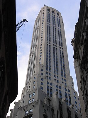
20 Exchange Place
Residential skyscraper in Manhattan, New York
Distance: Approx. 72 meters
Latitude and longitude: 40.70555556,-74.00972222
20 Exchange Place, formerly the City Bank–Farmers Trust Building, is a skyscraper in the Financial District of Lower Manhattan in New York City. Completed in 1931, it was designed by Cross & Cross in the Art Deco style as the headquarters of the City Bank–Farmers Trust Company, predecessor of Citigroup. The building, standing at approximately 741 feet (226 m) with 57 usable stories, was one of the city's tallest buildings and the world's tallest stone-clad building at the time of its completion.
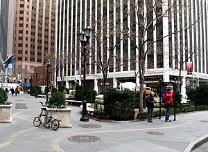
Hanover Square (Manhattan)
Square in Manhattan, New York
Distance: Approx. 100 meters
Latitude and longitude: 40.704607,-74.009453
Hanover Square is a square with a public park in the Financial District of Lower Manhattan in New York City. It is triangular in shape, formed by the intersections of Pearl Street and Hanover Street; Pearl Street and a street named "Hanover Square" itself (whose opposite side of Pearl continues as Hanover St.; and William Street (northern continuation of "Hanover Square" street) and Stone Street. The side between Hanover/Pearl intersection and William/Stone intersection is a pedestrian pathway along the building front facing the square and Pearl Street.

1 Wall Street Court
Residential building in Manhattan, New York
Distance: Approx. 50 meters
Latitude and longitude: 40.70527778,-74.00833333
1 Wall Street Court (also known as the Beaver Building and the Cocoa Exchange) is a residential building in the Financial District of Manhattan in New York City, New York. The 15-story building, designed by Clinton and Russell in the Renaissance Revival style, was completed in 1904 at the intersection of Wall, Pearl, and Beaver Streets. The building is shaped similarly to a flatiron because of its position at an acute angle formed by the junction of Pearl and Beaver Streets.

55 Wall Street
Building in Manhattan, New York
Distance: Approx. 92 meters
Latitude and longitude: 40.70611111,-74.00944444
55 Wall Street, formerly the National City Bank Building, is an eight-story building on Wall Street between William and Hanover streets in the Financial District of Lower Manhattan in New York City, New York, United States. The lowest three stories were completed in either 1841 or 1842 as the four-story Merchants' Exchange and designed by Isaiah Rogers in the Greek Revival style. Between 1907 and 1910, McKim, Mead & White removed the original fourth story and added five floors to create the present building.
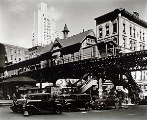
Hanover Square station
Former Manhattan Railway elevated station (closed 1950)
Distance: Approx. 88 meters
Latitude and longitude: 40.70466111,-74.00926667
The Hanover Square station was an express station on the demolished IRT Third Avenue Line in Manhattan, New York City. It had two tracks and one island platform. The station was originally built in 1878 by the New York Elevated Railroad.

63 Wall Street
Residential building in Manhattan, New York
Distance: Approx. 30 meters
Latitude and longitude: 40.70555556,-74.00861111
63 Wall Street, originally the Wall and Hanover Building, is a 37-story skyscraper on Wall Street in the Financial District of Manhattan in New York City. Built in 1929, it was designed by Delano & Aldrich as the headquarters of Brown Brothers & Co.
New York Gold Exchange
Distance: Approx. 83 meters
Latitude and longitude: 40.7057,-74.0098
The New York Gold Exchange was an exchange formed shortly after the beginning of the American Civil War for the purpose of creating an open market for transactions involving gold and the government-created paper currency, the greenback. Established in 1862, it closed in 1897.

Tontine Coffee House
Coffeehouse in Manhattan, New York
Distance: Approx. 80 meters
Latitude and longitude: 40.705486,-74.007964
The Tontine Coffee House was a coffeehouse in Manhattan, New York City, established in early 1793. Situated at 82 Wall Street, on the north-west corner of Water Street, it was built by a group of stockbrokers to serve as a meeting place for trade and correspondence. It was organized as a tontine, a type of investment plan, and funded by the sale of 203 shares of £200 each.
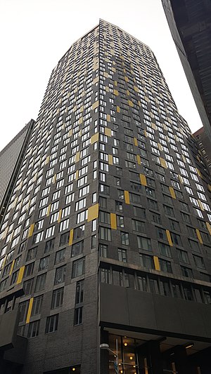
15 William
Residential skyscraper in Manhattan, New York
Distance: Approx. 93 meters
Latitude and longitude: 40.7054,-74.01
15 William, formerly known as the William Beaver House, is a 47-story, 528-foot-tall (161 m) condominium apartment building at 15 William Street in the Financial District of Manhattan, New York City. It opened in 2008, at which time it was the only ground-up residential development in the Financial District. 15 William was designed by the New York firms Tsao & McKown, Ismael Leyva Architects, and SLCE Architects, with interiors and public spaces designed by SPAN Architecture and Allied Works Architecture.
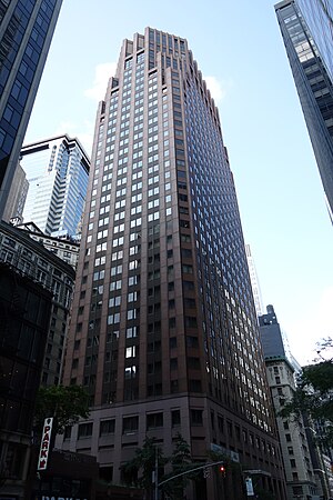
75 Wall Street
Mixed-use building in Manhattan, New York
Distance: Approx. 83 meters
Latitude and longitude: 40.7051,-74.008
75 Wall Street is a 43-story mixed-use building in the Financial District of Lower Manhattan in New York City. It contains Hyatt Centric Wall Street New York, a hotel with 253 rooms managed by Blue Sky Hospitality. Designed by Welton Becket & Associates and developed by London & Leeds as an office building, 75 Wall Street was announced in 1984 as the North American headquarters of British bank Barclays.
Weather in this IP's area
clear sky
-4 Celsius
-11 Celsius
-6 Celsius
-3 Celsius
1017 hPa
55 %
1017 hPa
1015 hPa
10000 meters
9.26 m/s
16.46 m/s
300 degree
